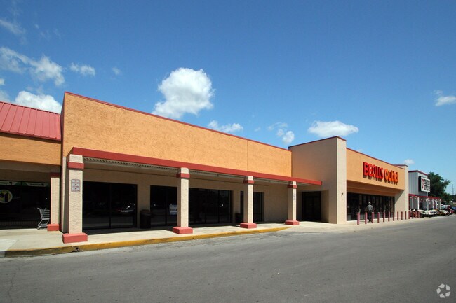
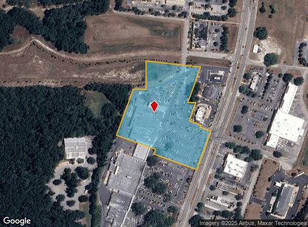
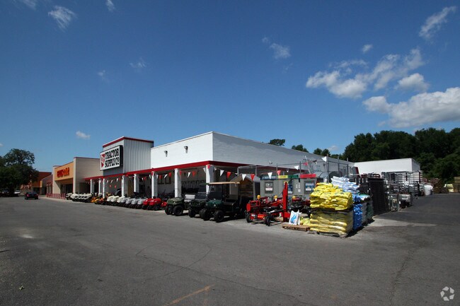
Property Record
11242 N Williams St, Dunnellon, FL 34432
NEARBY LISTINGS FOR SALE OR LEASE
Property Detail
11242 N Williams St
33639-004-00
SEC 26 TWP 16 RGE 18 COM AT NW COR OF SE 1/4 E 1239.87 FT TO POB S 89 DEG 54`52E 82.66 FT TO SW COR OF LANDS DESC IN OR 1267-0299 N 00 DEG 45`01E 186.45 FT S 83 DEG 21` 14E 374.30 FT S 20 DEG 10`30W 252.99 FT S 89 DEG 54`52E 54.63 FT S 20 DEG 10`30W
Regionalshoppingcenterormallwithanchorstore
Marion
AE
Florida
12017C0087D
6.50 AC
2025
Outlying Marion County
2025
Ocala
002703
Ocala, FL
49,319 SF
DEMOGRAPHICS near 11242 N Williams St
1 Mile
3 Mile
5 Mile
2024 Total Population
1,757
9,813
19,152
2029 Population
1,999
11,171
21,904
Pop Growth 2024-2029
+ 13.77%
+ 13.84%
+ 14.37%
Average Age
50
53
49
2024 Total Households
850
4,669
8,502
HH Growth 2024-2029
+ 13.76%
+ 13.69%
+ 14.14%
Median Household Inc
$39,273
$51,444
$51,843
Avg Household Size
2.00
2.10
2.20
2024 Avg HH Vehicles
2.00
2.00
2.00
Median Home Value
$174,640
$212,525
$192,102
Median Year Built
1980
1990
1991
Nearby Places
Map Layers
Map Styles
 Street
 Aerial
- Restaurants
- Banks
- Shops
- Fitness
- Groceries
Nearby Properties
Address
Land Use
TOTAL SIZE
Lot Size
Zoning
Address
Land Use
TOTAL SIZE
Lot Size
Zoning
166,189 SF
84.50 AC
A1
Address
Land Use
TOTAL SIZE
Lot Size
Zoning
158,264 SF
17.66 AC
B4
Address
Land Use
TOTAL SIZE
Lot Size
Zoning
84,326 SF
6.26 AC
B4
Address
Land Use
TOTAL SIZE
Lot Size
Zoning
99,841 SF
19.43 AC
R3
Address
Land Use
TOTAL SIZE
Lot Size
Zoning
14,939 SF
3.68 AC
B4
Address
Land Use
TOTAL SIZE
Lot Size
Zoning
55,882 SF
6.81 AC
B3
Address
Land Use
TOTAL SIZE
Lot Size
Zoning
48,986 SF
5.35 AC
B4
Address
Land Use
TOTAL SIZE
Lot Size
Zoning
29,200 SF
4.04 AC
P
Address
Land Use
TOTAL SIZE
Lot Size
Zoning
32,485 SF
28.63 AC
PSI
Address
Land Use
TOTAL SIZE
Lot Size
Zoning
48,528 SF
7.69 AC
B2
Address
Land Use
TOTAL SIZE
Lot Size
Zoning
44,240 SF
6.50 AC
B4
Address
Land Use
TOTAL SIZE
Lot Size
Zoning
10,436 SF
46.21 AC
R4
Address
Land Use
TOTAL SIZE
Lot Size
Zoning
1,728 SF
255.16 AC
R1
Address
Land Use
TOTAL SIZE
Lot Size
Zoning
16,129 SF
11.06 AC
B3
Address
Land Use
TOTAL SIZE
Lot Size
Zoning
27,088 SF
30 AC
R3A
Address
Land Use
TOTAL SIZE
Lot Size
Zoning
78,178 SF
4.32 AC
GNC
Address
Land Use
TOTAL SIZE
Lot Size
Zoning
8,932 SF
1 AC
R3
Address
Land Use
TOTAL SIZE
Lot Size
Zoning
15,725 SF
1.35 AC
B4
Address
Land Use
TOTAL SIZE
Lot Size
Zoning
14,993 SF
1.44 AC
B4
Address
Land Use
TOTAL SIZE
Lot Size
Zoning
133,930 SF
4.02 AC
IND
Address
Land Use
TOTAL SIZE
Lot Size
Zoning
7.15 AC
B4
Address
Land Use
TOTAL SIZE
Lot Size
Zoning
84,187 SF
21.17 AC
A1
Address
Land Use
TOTAL SIZE
Lot Size
Zoning
5,865 SF
3.18 AC
P
Address
Land Use
TOTAL SIZE
Lot Size
Zoning
8,640 SF
0.72 AC
NBR
Address
Land Use
TOTAL SIZE
Lot Size
Zoning
269.98 AC
A1
Address
Land Use
TOTAL SIZE
Lot Size
Zoning
84.72 AC
TCU
Address
Land Use
TOTAL SIZE
Lot Size
Zoning
12,319 SF
11.92 AC
A1
Address
Land Use
TOTAL SIZE
Lot Size
Zoning
12,526 SF
1.83 AC
GNC
Address
Land Use
TOTAL SIZE
Lot Size
Zoning
13,449 SF
4.36 AC
B2
Address
Land Use
TOTAL SIZE
Lot Size
Zoning
8,415 SF
1.24 AC
B3
The World's #1 Commercial Real Estate Marketplace
Connect with us
© 2026 CoStar Group
The information above has been obtained from sources believed reliable. While we do not doubt its accuracy we have not verified it and make no guarantee, warranty or representation about it. It is your responsibility to independently confirm its accuracy and completeness. Any projections, opinions, assumptions, or estimates used are for example only and do not represent the current or future performance of the property. The value of this transaction to you depends on tax and other factors which should be evaluated by your tax, financial, and legal advisors. You and your advisors should conduct a careful, independent investigation of the property to determine to your satisfaction the suitability of the property for your needs.