Property Record
1125 E Spokane St, Pasco, WA 99301
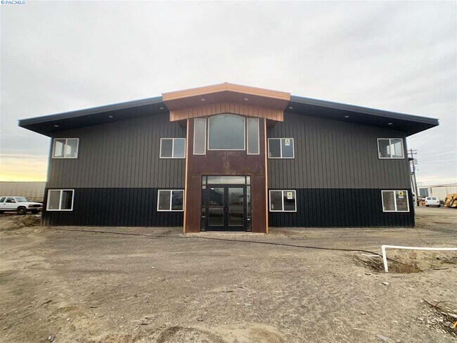


Property Detail
1125 E Spokane St
Kennewick-Richland, WA
PASCO LAND COS 1ST
112-093-012
Franklin
Industrialgeneral
Washington
2025
1
2025
4.58 AC
020102
Yakima/Kennewick
10,954 SF
Other Market Areas
NEARBY LISTINGS FOR SALE OR LEASE
DEMOGRAPHICS near 1125 E Spokane St
1 mile
3 mile
5 mile
2025 Total Population
12,747
42,542
111,014
2030 Population
13,238
44,152
115,365
Pop Growth 2025-2030
+ 3.85%
+ 3.78%
+ 3.92%
Average Age
32
33
35
2025 Total Households
3,459
12,489
35,978
HH Growth 2025-2030
+ 4.02%
+ 3.89%
+ 4.00%
Median Household Inc
$51,522
$57,704
$70,209
Avg Household Size
3.60
3.30
3.00
2025 Avg HH Vehicles
2.00
2.00
2.00
Median Home Value
$239,238
$264,292
$353,778
Median Year Built
1973
1970
1976
Nearby Places
Map Layers
Map Styles
 Street
 Aerial
Layers
 Traffic
 Biking
Places
Listings with unknown addresses are not visible on the map
- Restaurants
- Banks
- Shops
- Fitness
- Groceries
PUBLIC TRANSPORTATION
COMMUTER RAIL
Drive
Walk
Distance
3 min
1.4 mi
AIRPORT
Tri-Cities
Drive
Walk
Distance
Tri-Cities
7 min
3.8 mi
SALE & LEASE HISTORY
LISTING DATE
SALE/LEASE

Nov 06, 2020
For Sale
Nov 05, 2021
For Sale
May 17, 2021
For Sale
Apr 06, 2020
For Sale
Nearby Properties
Address
Land Use
TOTAL SIZE
Lot Size
Zoning
Address
Land Use
TOTAL SIZE
Lot Size
Zoning
1,078,419 SF
114.48 AC
Address
Land Use
TOTAL SIZE
Lot Size
Zoning
1,049,518 SF
104.40 AC
Address
Land Use
TOTAL SIZE
Lot Size
Zoning
277,478 SF
27.86 AC
Address
Land Use
TOTAL SIZE
Lot Size
Zoning
53,980 SF
25.90 AC
Address
Land Use
TOTAL SIZE
Lot Size
Zoning
2,863,808 SF
28.33 AC
Address
Land Use
TOTAL SIZE
Lot Size
Zoning
375,317 SF
17.68 AC
Address
Land Use
TOTAL SIZE
Lot Size
Zoning
189,054 SF
28.48 AC
Address
Land Use
TOTAL SIZE
Lot Size
Zoning
444,084 SF
58 AC
Address
Land Use
TOTAL SIZE
Lot Size
Zoning
204,680 SF
39.50 AC
Address
Land Use
TOTAL SIZE
Lot Size
Zoning
161,465 SF
24.12 AC
Address
Land Use
TOTAL SIZE
Lot Size
Zoning
214,102 SF
9.88 AC
Address
Land Use
TOTAL SIZE
Lot Size
Zoning
163,900 SF
11.90 AC
Address
Land Use
TOTAL SIZE
Lot Size
Zoning
140,275 SF
6.36 AC
Address
Land Use
TOTAL SIZE
Lot Size
Zoning
153,320 SF
7.37 AC
Address
Land Use
TOTAL SIZE
Lot Size
Zoning
35,284 SF
30.53 AC
Address
Land Use
TOTAL SIZE
Lot Size
Zoning
114,673 SF
6.58 AC
Address
Land Use
TOTAL SIZE
Lot Size
Zoning
84,951 SF
4.39 AC
Address
Land Use
TOTAL SIZE
Lot Size
Zoning
64,936 SF
Address
Land Use
TOTAL SIZE
Lot Size
Zoning
84,680 SF
3 AC
Address
Land Use
TOTAL SIZE
Lot Size
Zoning
67,635 SF
5.95 AC
Address
Land Use
TOTAL SIZE
Lot Size
Zoning
241,912 SF
12.99 AC
Address
Land Use
TOTAL SIZE
Lot Size
Zoning
70,416 SF
2.73 AC
Address
Land Use
TOTAL SIZE
Lot Size
Zoning
584,810 SF
Address
Land Use
TOTAL SIZE
Lot Size
Zoning
88,510 SF
14.04 AC
Address
Land Use
TOTAL SIZE
Lot Size
Zoning
20,919 SF
58.49 AC
KENNEWICK
Address
Land Use
TOTAL SIZE
Lot Size
Zoning
103,750 SF
14.97 AC
Address
Land Use
TOTAL SIZE
Lot Size
Zoning
58,701 SF
11.34 AC
Address
Land Use
TOTAL SIZE
Lot Size
Zoning
80,604 SF
4.30 AC
Address
Land Use
TOTAL SIZE
Lot Size
Zoning
75,542 SF
6.36 AC
Address
Land Use
TOTAL SIZE
Lot Size
Zoning
125,508 SF
3.49 AC
The World's #1 Commercial Real Estate Marketplace
Connect with us
© 2026 CoStar Group
The information above has been obtained from sources believed reliable. While we do not doubt its accuracy we have not verified it and make no guarantee, warranty or representation about it. It is your responsibility to independently confirm its accuracy and completeness. Any projections, opinions, assumptions, or estimates used are for example only and do not represent the current or future performance of the property. The value of this transaction to you depends on tax and other factors which should be evaluated by your tax, financial, and legal advisors. You and your advisors should conduct a careful, independent investigation of the property to determine to your satisfaction the suitability of the property for your needs.