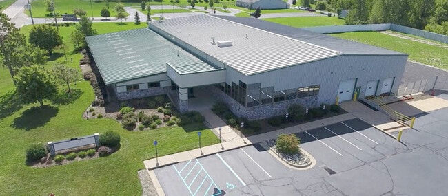
Property Record
1125 N Cedar Rd, Mason, MI 48854

NEARBY LISTINGS FOR SALE OR LEASE
Property Detail
1125 N Cedar Rd
25-05-25-376-009
The Gardens
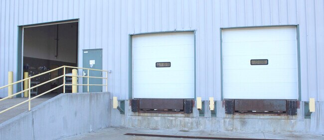
Warehouse
COM @ S 1/4 COR SEC 25, TH N88?39'12W ON S SEC LN 283 FT
X
Ingham
26065C0251D
Michigan
2024
6.63 AC
2025
Southern Lansing
005502
West Michigan
16,000 SF
Lansing-East Lansing, MI
DEMOGRAPHICS near 1125 N Cedar Rd
1 Mile
3 Mile
5 Mile
2024 Total Population
780
18,347
46,133
2029 Population
763
18,157
45,770
Pop Growth 2024-2029
(2.18%)
(1.04%)
(0.79%)
Average Age
39
41
39
2024 Total Households
300
7,673
19,295
HH Growth 2024-2029
(2.33%)
(0.96%)
(0.81%)
Median Household Inc
$88,392
$68,681
$67,959
Avg Household Size
2.60
2.30
2.30
2024 Avg HH Vehicles
2.00
2.00
2.00
Median Home Value
$178,294
$166,304
$175,467
Median Year Built
1986
1979
1979
Nearby Places
Map Layers
Map Styles
 Street
 Aerial
- Restaurants
- Banks
- Shops
- Fitness
- Groceries
PUBLIC TRANSPORTATION
AIRPORT
Capital Region International
DRIVE
WALK
Distance
Capital Region International
25 min
13.6 mi
SALE & LEASE HISTORY
LISTING DATE
SALE/LEASE

Dec 16, 2021
For Sale
Nearby Properties
Address
Land Use
TOTAL SIZE
Lot Size
Zoning
Address
Land Use
TOTAL SIZE
Lot Size
Zoning
146,160 SF
88.98 AC
I-1
Address
Land Use
TOTAL SIZE
Lot Size
Zoning
15,000 SF
Address
Land Use
TOTAL SIZE
Lot Size
Zoning
107,580 SF
Address
Land Use
TOTAL SIZE
Lot Size
Zoning
178,096 SF
22.80 AC
IP
Address
Land Use
TOTAL SIZE
Lot Size
Zoning
269,915 SF
Address
Land Use
TOTAL SIZE
Lot Size
Zoning
912 SF
20.97 AC
RM
Address
Land Use
TOTAL SIZE
Lot Size
Zoning
7,868 SF
12.03 AC
RM
Address
Land Use
TOTAL SIZE
Lot Size
Zoning
8,341 SF
27.70 AC
RM
Address
Land Use
TOTAL SIZE
Lot Size
Zoning
616,146 SF
111.68 AC
IP
Address
Land Use
TOTAL SIZE
Lot Size
Zoning
10,112 SF
12.57 AC
RM-1
Address
Land Use
TOTAL SIZE
Lot Size
Zoning
47,352 SF
2.41 AC
TC
Address
Land Use
TOTAL SIZE
Lot Size
Zoning
14,981 SF
12.66 AC
R-1E
Address
Land Use
TOTAL SIZE
Lot Size
Zoning
16,913 SF
11.25 AC
R-1E
Address
Land Use
TOTAL SIZE
Lot Size
Zoning
15,439 SF
13.13 AC
R-1E
Address
Land Use
TOTAL SIZE
Lot Size
Zoning
137,084 SF
6.86 AC
M1
Address
Land Use
TOTAL SIZE
Lot Size
Zoning
128,381 SF
11.61 AC
IP
Address
Land Use
TOTAL SIZE
Lot Size
Zoning
65,728 SF
18.32 AC
IP
Address
Land Use
TOTAL SIZE
Lot Size
Zoning
55.34 AC
MH
Address
Land Use
TOTAL SIZE
Lot Size
Zoning
1,708 SF
20.73 AC
RM-1
Address
Land Use
TOTAL SIZE
Lot Size
Zoning
13,824 SF
15.39 AC
R-1E
Address
Land Use
TOTAL SIZE
Lot Size
Zoning
17,136 SF
5.38 AC
RM-1
Address
Land Use
TOTAL SIZE
Lot Size
Zoning
9,710 SF
5.19 AC
C-2
Address
Land Use
TOTAL SIZE
Lot Size
Zoning
7,760 SF
4.58 AC
RM-1
Address
Land Use
TOTAL SIZE
Lot Size
Zoning
7,341 SF
8.53 AC
RM-1
Address
Land Use
TOTAL SIZE
Lot Size
Zoning
Address
Land Use
TOTAL SIZE
Lot Size
Zoning
6,768 SF
228.81 AC
A-1
Address
Land Use
TOTAL SIZE
Lot Size
Zoning
40,000 SF
2.74 AC
IP
Address
Land Use
TOTAL SIZE
Lot Size
Zoning
5,922 SF
6.91 AC
RM-1
Address
Land Use
TOTAL SIZE
Lot Size
Zoning
31.63 AC
MH
Address
Land Use
TOTAL SIZE
Lot Size
Zoning
81,204 SF
12.08 AC
IA
The World's #1 Commercial Real Estate Marketplace
Connect with us
© 2025 CoStar Group
The information above has been obtained from sources believed reliable. While we do not doubt its accuracy we have not verified it and make no guarantee, warranty or representation about it. It is your responsibility to independently confirm its accuracy and completeness. Any projections, opinions, assumptions, or estimates used are for example only and do not represent the current or future performance of the property. The value of this transaction to you depends on tax and other factors which should be evaluated by your tax, financial, and legal advisors. You and your advisors should conduct a careful, independent investigation of the property to determine to your satisfaction the suitability of the property for your needs.