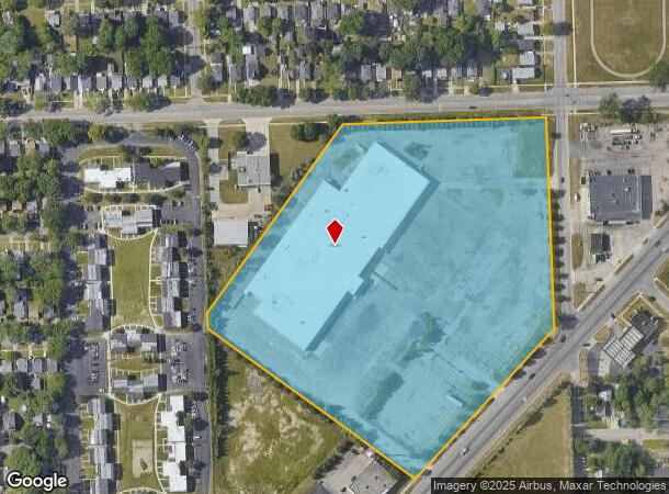
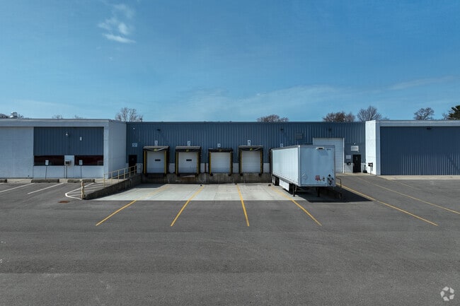
Property Record
1125 N Perry St, Pontiac, MI 48340

NEARBY LISTINGS FOR SALE OR LEASE
Property Detail
1125 N Perry St
14-21-226-004
T3N, R10E, SEC 21 PART OF NE 1/4 BEG AT PT DIST S 00-06-00 W 43 FT & N 89-36-15 W 43 FT FROM NE SEC COR, TH N 89-36-15 W 534
Warehouse
Oakland
X
Michigan
26125C0367F
13.29 AC
2024
Auburn Hills, Pontiac & Rochester
2024
Detroit
141400
Detroit-Warren-Dearborn, MI
112,047 SF
DEMOGRAPHICS near 1125 N Perry St
1 Mile
3 Mile
5 Mile
2024 Total Population
11,751
63,370
159,730
2029 Population
11,664
63,329
159,333
Pop Growth 2024-2029
(0.74%)
(0.06%)
(0.25%)
Average Age
35
37
40
2024 Total Households
4,315
25,322
64,888
HH Growth 2024-2029
(0.81%)
(0.15%)
(0.29%)
Median Household Inc
$42,720
$41,103
$61,615
Avg Household Size
2.60
2.40
2.30
2024 Avg HH Vehicles
2.00
1.00
2.00
Median Home Value
$75,513
$88,956
$223,520
Median Year Built
1956
1963
1971
Nearby Places
Map Layers
Map Styles
 Street
 Aerial
- Restaurants
- Banks
- Shops
- Fitness
- Groceries
PUBLIC TRANSPORTATION
COMMUTER RAIL
DRIVE
WALK
Distance
8 min
2.7 mi
AIRPORT
Bishop International
DRIVE
WALK
Distance
Bishop International
58 min
39.4 mi
Windsor International
DRIVE
WALK
Distance
Windsor International
61 min
40.3 mi
Detroit Metro Wayne County
DRIVE
WALK
Distance
Detroit Metro Wayne County
66 min
49.8 mi
SALE & LEASE HISTORY
LISTING DATE
SALE/LEASE

Jan 19, 2021
For Lease
Jan 19, 2021
For Sale
Feb 04, 2019
For Sale
Nearby Properties
Address
Land Use
TOTAL SIZE
Lot Size
Zoning
Address
Land Use
TOTAL SIZE
Lot Size
Zoning
7,879,586 SF
457.68 AC
TR
Address
Land Use
TOTAL SIZE
Lot Size
Zoning
2,734,739 SF
80.39 AC
Address
Land Use
TOTAL SIZE
Lot Size
Zoning
803,597 SF
67 AC
SP
Address
Land Use
TOTAL SIZE
Lot Size
Zoning
238,755 SF
Address
Land Use
TOTAL SIZE
Lot Size
Zoning
316,358 SF
20.89 AC
P
Address
Land Use
TOTAL SIZE
Lot Size
Zoning
1,771,589 SF
96.73 AC
Address
Land Use
TOTAL SIZE
Lot Size
Zoning
430,338 SF
46.09 AC
Address
Land Use
TOTAL SIZE
Lot Size
Zoning
608,251 SF
50.49 AC
II
Address
Land Use
TOTAL SIZE
Lot Size
Zoning
238,755 SF
18.12 AC
Address
Land Use
TOTAL SIZE
Lot Size
Zoning
246,150 SF
26.64 AC
TR
Address
Land Use
TOTAL SIZE
Lot Size
Zoning
487,797 SF
34.74 AC
TR
Address
Land Use
TOTAL SIZE
Lot Size
Zoning
278,387 SF
43.37 AC
Address
Land Use
TOTAL SIZE
Lot Size
Zoning
430,338 SF
43.22 AC
Address
Land Use
TOTAL SIZE
Lot Size
Zoning
214,772 SF
Address
Land Use
TOTAL SIZE
Lot Size
Zoning
213,112 SF
12.17 AC
I1
Address
Land Use
TOTAL SIZE
Lot Size
Zoning
101,568 SF
8.06 AC
Address
Land Use
TOTAL SIZE
Lot Size
Zoning
278,387 SF
Address
Land Use
TOTAL SIZE
Lot Size
Zoning
455,045 SF
23.47 AC
I1
Address
Land Use
TOTAL SIZE
Lot Size
Zoning
135,230 SF
Address
Land Use
TOTAL SIZE
Lot Size
Zoning
232,860 SF
28.30 AC
I1
Address
Land Use
TOTAL SIZE
Lot Size
Zoning
174,019 SF
9.66 AC
Address
Land Use
TOTAL SIZE
Lot Size
Zoning
186,242 SF
Address
Land Use
TOTAL SIZE
Lot Size
Zoning
172,076 SF
11.18 AC
Address
Land Use
TOTAL SIZE
Lot Size
Zoning
Address
Land Use
TOTAL SIZE
Lot Size
Zoning
209,596 SF
Address
Land Use
TOTAL SIZE
Lot Size
Zoning
209,596 SF
9.16 AC
TR
Address
Land Use
TOTAL SIZE
Lot Size
Zoning
136,061 SF
14.64 AC
Address
Land Use
TOTAL SIZE
Lot Size
Zoning
30,720 SF
103.14 AC
I2
Address
Land Use
TOTAL SIZE
Lot Size
Zoning
173,974 SF
31.37 AC
TR
Address
Land Use
TOTAL SIZE
Lot Size
Zoning
199,125 SF
47.43 AC
The World's #1 Commercial Real Estate Marketplace
Connect with us
© 2025 CoStar Group
The information above has been obtained from sources believed reliable. While we do not doubt its accuracy we have not verified it and make no guarantee, warranty or representation about it. It is your responsibility to independently confirm its accuracy and completeness. Any projections, opinions, assumptions, or estimates used are for example only and do not represent the current or future performance of the property. The value of this transaction to you depends on tax and other factors which should be evaluated by your tax, financial, and legal advisors. You and your advisors should conduct a careful, independent investigation of the property to determine to your satisfaction the suitability of the property for your needs.