Property Record
1125 Ne Kane Dr, Gresham, OR 97030
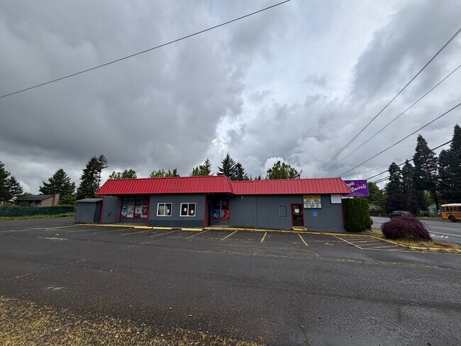

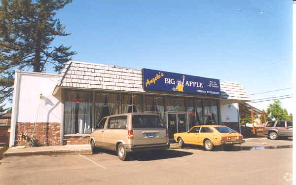

Property Detail
1125 Ne Kane Dr
R286114
THE I W TR, LOT 16 EXC W 100 N 90 OF S 297 OF & EXC PT IN ST
Commercialnec
Multnomah
GC
Oregon
B and X Area of moderate flood hazard, usually the area between the limits of the 100-year and 500-year floods.
16
2025
0.34 AC
2025
Gresham
010410
Portland
3,533 SF
Portland-Vancouver-Hillsboro, OR-WA
NEARBY LISTINGS FOR SALE OR LEASE
DEMOGRAPHICS near 1125 Ne Kane Dr
1 mile
3 mile
5 mile
2024 Total Population
15,322
90,326
164,372
2029 Population
14,978
88,932
161,771
Pop Growth 2024-2029
(2.25%)
(1.54%)
(1.58%)
Average Age
40
40
40
2024 Total Households
5,724
32,856
58,223
HH Growth 2024-2029
(2.73%)
(1.82%)
(1.89%)
Median Household Inc
$62,562
$76,459
$74,732
Avg Household Size
2.50
2.70
2.70
2024 Avg HH Vehicles
2.00
2.00
2.00
Median Home Value
$423,573
$449,992
$451,596
Median Year Built
1978
1984
1982
Nearby Places
Map Layers
Map Styles
 Street
 Aerial
Transit
 Traffic
 Biking
Places
Listings with unknown addresses are not visible on the map
- Restaurants
- Banks
- Shops
- Fitness
- Groceries
PUBLIC TRANSPORTATION
AIRPORT
Portland International
Drive
Walk
Distance
Portland International
25 min
15.0 mi
SALE & LEASE HISTORY
LISTING DATE
SALE/LEASE

May 14, 2025
For Sale
May 10, 2022
For Lease
Jun 19, 2019
For Sale
Jul 01, 2025
For Lease
Nearby Properties
Address
Land Use
TOTAL SIZE
Lot Size
Zoning
Address
Land Use
TOTAL SIZE
Lot Size
Zoning
40.81 AC
LDR-5
Address
Land Use
TOTAL SIZE
Lot Size
Zoning
Address
Land Use
TOTAL SIZE
Lot Size
Zoning
3.20 AC
DEM
Address
Land Use
TOTAL SIZE
Lot Size
Zoning
137.54 AC
GI
Address
Land Use
TOTAL SIZE
Lot Size
Zoning
300,843 SF
37.27 AC
MUA20
Address
Land Use
TOTAL SIZE
Lot Size
Zoning
302,114 SF
31.69 AC
R-5
Address
Land Use
TOTAL SIZE
Lot Size
Zoning
75,850 SF
11.55 AC
LDR-5
Address
Land Use
TOTAL SIZE
Lot Size
Zoning
8.69 AC
NULL
Address
Land Use
TOTAL SIZE
Lot Size
Zoning
836,366 SF
38.86 AC
LI
Address
Land Use
TOTAL SIZE
Lot Size
Zoning
197,834 SF
8.67 AC
R5
Address
Land Use
TOTAL SIZE
Lot Size
Zoning
237,815 SF
22.70 AC
TLDR
Address
Land Use
TOTAL SIZE
Lot Size
Zoning
219,470 SF
9.77 AC
R_MF
Address
Land Use
TOTAL SIZE
Lot Size
Zoning
118,460 SF
28.10 AC
BP
Address
Land Use
TOTAL SIZE
Lot Size
Zoning
213,544 SF
6.64 AC
A2
Address
Land Use
TOTAL SIZE
Lot Size
Zoning
273,264 SF
11.39 AC
CMF
Address
Land Use
TOTAL SIZE
Lot Size
Zoning
85,380 SF
5.04 AC
TD
Address
Land Use
TOTAL SIZE
Lot Size
Zoning
156,393 SF
5.82 AC
GC
Address
Land Use
TOTAL SIZE
Lot Size
Zoning
238,492 SF
13.10 AC
CMF
Address
Land Use
TOTAL SIZE
Lot Size
Zoning
254,580 SF
4.76 AC
TDHC
Address
Land Use
TOTAL SIZE
Lot Size
Zoning
733,232 SF
37.41 AC
NULL
Address
Land Use
TOTAL SIZE
Lot Size
Zoning
222,022 SF
11.64 AC
CMF
Address
Land Use
TOTAL SIZE
Lot Size
Zoning
83,072 SF
9.58 AC
LDR-5
Address
Land Use
TOTAL SIZE
Lot Size
Zoning
95,642 SF
5.30 AC
HI
Address
Land Use
TOTAL SIZE
Lot Size
Zoning
115,600 SF
28.24 AC
LDR-5
Address
Land Use
TOTAL SIZE
Lot Size
Zoning
61,524 SF
7.31 AC
LDR-5
Address
Land Use
TOTAL SIZE
Lot Size
Zoning
235,728 SF
6.64 AC
MDR-24
Address
Land Use
TOTAL SIZE
Lot Size
Zoning
141,899 SF
13.51 AC
DMU
Address
Land Use
TOTAL SIZE
Lot Size
Zoning
19.55 AC
GI
Address
Land Use
TOTAL SIZE
Lot Size
Zoning
87,429 SF
0.95 AC
DTM
Address
Land Use
TOTAL SIZE
Lot Size
Zoning
194,991 SF
5.56 AC
TCC
The World's #1 Commercial Real Estate Marketplace
Connect with us
© 2026 CoStar Group
The information above has been obtained from sources believed reliable. While we do not doubt its accuracy we have not verified it and make no guarantee, warranty or representation about it. It is your responsibility to independently confirm its accuracy and completeness. Any projections, opinions, assumptions, or estimates used are for example only and do not represent the current or future performance of the property. The value of this transaction to you depends on tax and other factors which should be evaluated by your tax, financial, and legal advisors. You and your advisors should conduct a careful, independent investigation of the property to determine to your satisfaction the suitability of the property for your needs.