Property Record
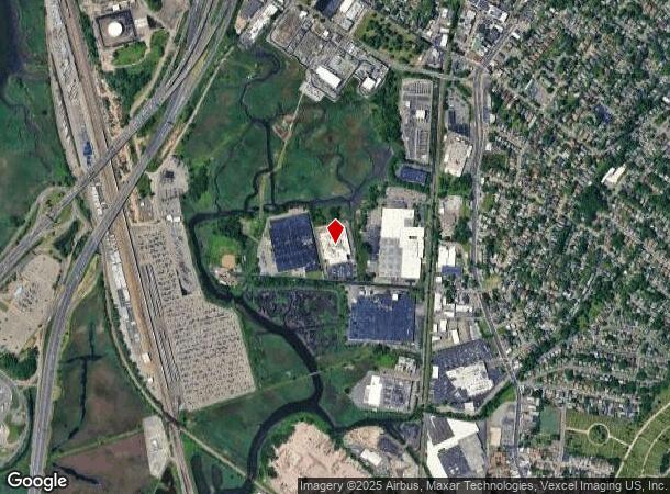
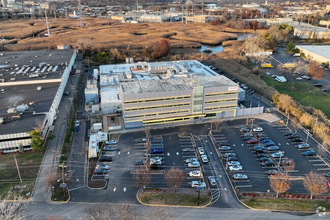
1125 Pleasantview Ter, Ridgefield, NJ 07657


NEARBY LISTINGS FOR SALE OR LEASE
Property Detail
1125 Pleasantview Ter
49-04014-0000-00011-0000-HM
8.2AC
Industrialgeneral
Bergen
AE
New Jersey
34003C0259H
11
2023
8.20 AC
2025
Englewood/Edgewater
045200
Northern New Jersey
87,468 SF
New York-Jersey City-White Plains, NY-NJ
DEMOGRAPHICS near 1125 Pleasantview Ter
1 Mile
3 Mile
5 Mile
2024 Total Population
9,622
244,073
1,426,209
2029 Population
9,482
237,296
1,343,919
Pop Growth 2024-2029
(1.45%)
(2.78%)
(5.77%)
Average Age
41
42
41
2024 Total Households
3,384
94,932
610,029
HH Growth 2024-2029
(1.60%)
(2.74%)
(6.10%)
Median Household Inc
$81,698
$79,314
$73,584
Avg Household Size
2.70
2.50
2.20
2024 Avg HH Vehicles
2.00
1.00
1.00
Median Home Value
$519,074
$485,871
$686,132
Median Year Built
1959
1964
1955
Nearby Places
Map Layers
Map Styles
 Street
 Aerial
- Restaurants
- Banks
- Shops
- Fitness
- Groceries
PUBLIC TRANSPORTATION
COMMUTER RAIL
Meadowlands Sports Complex Station (BetMGM Meadowlands Rail Line - NJ TRANSIT RAIL)
DRIVE
WALK
Distance
Meadowlands Sports Complex Station (BetMGM Meadowlands Rail Line - NJ TRANSIT RAIL)
14 min
7.2 mi
Wood Ridge (Pascack Valley Line - NJ Transit Commuter Rail (NJ Transit))
DRIVE
WALK
Distance
Wood Ridge (Pascack Valley Line - NJ Transit Commuter Rail (NJ Transit))
17 min
9.1 mi
AIRPORT
Newark Liberty International
DRIVE
WALK
Distance
Newark Liberty International
21 min
14.8 mi
LaGuardia
DRIVE
WALK
Distance
LaGuardia
29 min
15.8 mi
John F Kennedy International
DRIVE
WALK
Distance
John F Kennedy International
40 min
26.9 mi
Freight Ports
NY - Red Hook Container Terminal
DRIVE
WALK
Distance
NY - Red Hook Container Terminal
31 min
14.9 mi
Nearby Properties
Address
Land Use
TOTAL SIZE
Lot Size
Zoning
Address
Land Use
TOTAL SIZE
Lot Size
Zoning
Address
Land Use
TOTAL SIZE
Lot Size
Zoning
Address
Land Use
TOTAL SIZE
Lot Size
Zoning
Address
Land Use
TOTAL SIZE
Lot Size
Zoning
Address
Land Use
TOTAL SIZE
Lot Size
Zoning
Address
Land Use
TOTAL SIZE
Lot Size
Zoning
174 AC
P2
Address
Land Use
TOTAL SIZE
Lot Size
Zoning
Address
Land Use
TOTAL SIZE
Lot Size
Zoning
26.93 AC
R8
Address
Land Use
TOTAL SIZE
Lot Size
Zoning
555 SF
4.89 AC
H
Address
Land Use
TOTAL SIZE
Lot Size
Zoning
35.58 AC
I
Address
Land Use
TOTAL SIZE
Lot Size
Zoning
4.87 AC
R11
Address
Land Use
TOTAL SIZE
Lot Size
Zoning
68.93 AC
Address
Land Use
TOTAL SIZE
Lot Size
Zoning
7.64 AC
Address
Land Use
TOTAL SIZE
Lot Size
Zoning
45.60 AC
Address
Land Use
TOTAL SIZE
Lot Size
Zoning
8.60 AC
P1
Address
Land Use
TOTAL SIZE
Lot Size
Zoning
13.60 AC
Address
Land Use
TOTAL SIZE
Lot Size
Zoning
4.40 AC
Address
Land Use
TOTAL SIZE
Lot Size
Zoning
3.60 AC
OR1
Address
Land Use
TOTAL SIZE
Lot Size
Zoning
2,056 SF
0.06 AC
R1
Address
Land Use
TOTAL SIZE
Lot Size
Zoning
489 SF
1.24 AC
B2A
Address
Land Use
TOTAL SIZE
Lot Size
Zoning
13.09 AC
Address
Land Use
TOTAL SIZE
Lot Size
Zoning
555 SF
32 AC
H
Address
Land Use
TOTAL SIZE
Lot Size
Zoning
3.75 AC
Address
Land Use
TOTAL SIZE
Lot Size
Zoning
26 AC
H
Address
Land Use
TOTAL SIZE
Lot Size
Zoning
555 SF
23 AC
Address
Land Use
TOTAL SIZE
Lot Size
Zoning
3.62 AC
R5
Address
Land Use
TOTAL SIZE
Lot Size
Zoning
2 AC
R11
Address
Land Use
TOTAL SIZE
Lot Size
Zoning
2.55 AC
D5
Address
Land Use
TOTAL SIZE
Lot Size
Zoning
5.87 AC
R10
Address
Land Use
TOTAL SIZE
Lot Size
Zoning
The World's #1 Commercial Real Estate Marketplace
Connect with us
© 2025 CoStar Group
The information above has been obtained from sources believed reliable. While we do not doubt its accuracy we have not verified it and make no guarantee, warranty or representation about it. It is your responsibility to independently confirm its accuracy and completeness. Any projections, opinions, assumptions, or estimates used are for example only and do not represent the current or future performance of the property. The value of this transaction to you depends on tax and other factors which should be evaluated by your tax, financial, and legal advisors. You and your advisors should conduct a careful, independent investigation of the property to determine to your satisfaction the suitability of the property for your needs.