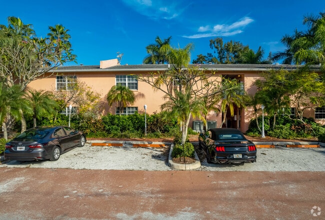
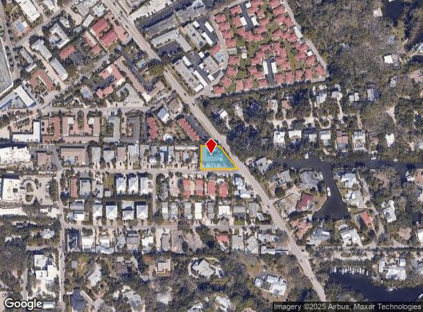
Property Record
1125 Point Of Rocks Rd, Sarasota, FL 34242


NEARBY LISTINGS FOR SALE OR LEASE
-
-
View all Sarasota listings for sale on LoopNet.com
Property Detail
1125 Point Of Rocks Rd
North Port-Sarasota-Bradenton, FL
Point Of Rocks Terrace
0108-17-0056
LOTS 12 & 13 POINT OF ROCKS TERRACE
Hotel
Sarasota
AE
Florida
12115C0206G
12,13
2024
0.36 AC
2025
Sarasota/Beaches
001909
Tampa/St Petersburg
7,124 SF
DEMOGRAPHICS near 1125 Point Of Rocks Rd
1 Mile
3 Mile
5 Mile
2024 Total Population
5,877
44,926
101,870
2029 Population
7,214
52,793
118,137
Pop Growth 2024-2029
+ 22.75%
+ 17.51%
+ 15.97%
Average Age
59
55
52
2024 Total Households
3,080
22,580
49,095
HH Growth 2024-2029
+ 22.82%
+ 17.72%
+ 16.16%
Median Household Inc
$93,462
$78,470
$79,346
Avg Household Size
1.90
1.90
2.00
2024 Avg HH Vehicles
2.00
2.00
2.00
Median Home Value
$528,742
$430,257
$411,421
Median Year Built
1975
1977
1980
Nearby Places
Map Layers
Map Styles
 Street
 Aerial
- Restaurants
- Banks
- Shops
- Fitness
- Groceries
PUBLIC TRANSPORTATION
AIRPORT
Sarasota/Bradenton International
DRIVE
WALK
Distance
Sarasota/Bradenton International
24 min
12.2 mi
Freight Ports
Port Manatee
DRIVE
WALK
Distance
Port Manatee
49 min
35.2 mi
Nearby Properties
Address
Land Use
TOTAL SIZE
Lot Size
Zoning
Address
Land Use
TOTAL SIZE
Lot Size
Zoning
588,839 SF
42.33 AC
GU
Address
Land Use
TOTAL SIZE
Lot Size
Zoning
530,029 SF
14.92 AC
RMF4
Address
Land Use
TOTAL SIZE
Lot Size
Zoning
11,781 SF
43.95 AC
GU
Address
Land Use
TOTAL SIZE
Lot Size
Zoning
312,294 SF
40.21 AC
OPI
Address
Land Use
TOTAL SIZE
Lot Size
Zoning
332,822 SF
34.74 AC
CG
Address
Land Use
TOTAL SIZE
Lot Size
Zoning
150,433 SF
10.55 AC
RMF4
Address
Land Use
TOTAL SIZE
Lot Size
Zoning
223,929 SF
28.24 AC
RMF1
Address
Land Use
TOTAL SIZE
Lot Size
Zoning
17,785 SF
56.32 AC
RMF2
Address
Land Use
TOTAL SIZE
Lot Size
Zoning
148,339 SF
12.86 AC
CG
Address
Land Use
TOTAL SIZE
Lot Size
Zoning
233,075 SF
19.49 AC
RMF2
Address
Land Use
TOTAL SIZE
Lot Size
Zoning
133,430 SF
19.60 AC
GU
Address
Land Use
TOTAL SIZE
Lot Size
Zoning
146,339 SF
12.54 AC
CG
Address
Land Use
TOTAL SIZE
Lot Size
Zoning
140,372 SF
14.31 AC
CG
Address
Land Use
TOTAL SIZE
Lot Size
Zoning
123,338 SF
8.53 AC
OPI
Address
Land Use
TOTAL SIZE
Lot Size
Zoning
145,945 SF
13.93 AC
CG
Address
Land Use
TOTAL SIZE
Lot Size
Zoning
96,425 SF
8.59 AC
OPI
Address
Land Use
TOTAL SIZE
Lot Size
Zoning
139,974 SF
6.07 AC
RMF4
Address
Land Use
TOTAL SIZE
Lot Size
Zoning
184,766 SF
12.70 AC
RMF3
Address
Land Use
TOTAL SIZE
Lot Size
Zoning
81,166 SF
13.18 AC
GU
Address
Land Use
TOTAL SIZE
Lot Size
Zoning
86,102 SF
5.23 AC
RMF3
Address
Land Use
TOTAL SIZE
Lot Size
Zoning
46,727 SF
38.73 AC
CG
Address
Land Use
TOTAL SIZE
Lot Size
Zoning
49,691 SF
360.97 AC
RSF2
Address
Land Use
TOTAL SIZE
Lot Size
Zoning
150,217 SF
14.83 AC
CG
Address
Land Use
TOTAL SIZE
Lot Size
Zoning
13,643 SF
36.64 AC
GU
Address
Land Use
TOTAL SIZE
Lot Size
Zoning
33,200 SF
16.91 AC
RSF1
Address
Land Use
TOTAL SIZE
Lot Size
Zoning
38,517 SF
7.56 AC
CI
Address
Land Use
TOTAL SIZE
Lot Size
Zoning
7,969 SF
38.20 AC
RMH
Address
Land Use
TOTAL SIZE
Lot Size
Zoning
15,095 SF
2.78 AC
RE2
Address
Land Use
TOTAL SIZE
Lot Size
Zoning
704 SF
1.80 AC
RSF1
Address
Land Use
TOTAL SIZE
Lot Size
Zoning
44,403 SF
20.98 AC
RSF3
The World's #1 Commercial Real Estate Marketplace
Connect with us
© 2025 CoStar Group
The information above has been obtained from sources believed reliable. While we do not doubt its accuracy we have not verified it and make no guarantee, warranty or representation about it. It is your responsibility to independently confirm its accuracy and completeness. Any projections, opinions, assumptions, or estimates used are for example only and do not represent the current or future performance of the property. The value of this transaction to you depends on tax and other factors which should be evaluated by your tax, financial, and legal advisors. You and your advisors should conduct a careful, independent investigation of the property to determine to your satisfaction the suitability of the property for your needs.