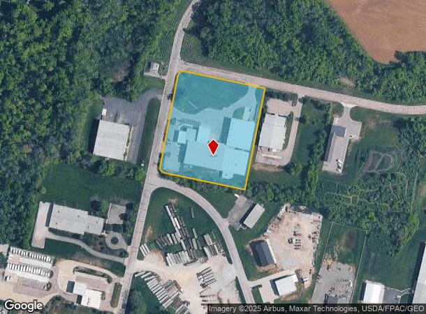
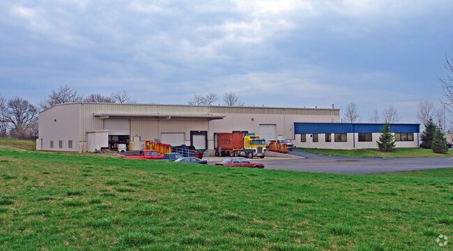
Property Record
1125 S Patton St, Xenia, OH 45385

NEARBY LISTINGS FOR SALE OR LEASE
Property Detail
1125 S Patton St
Dayton, OH
Industrial Park
M40-0002-0029-0-0002-00
ARNOVITZ INDUSTRIAL PARK LOT 1 SEC ONE S PATTON ST
Manufacturinglight
Greene
X
Ohio
39057C0145E
1
2024
3.93 AC
2024
Southeast Dayton
240700
Cincinnati/Dayton
12,200 SF
DEMOGRAPHICS near 1125 S Patton St
1 Mile
3 Mile
5 Mile
2024 Total Population
3,595
24,731
33,394
2029 Population
3,696
25,338
34,100
Pop Growth 2024-2029
+ 2.81%
+ 2.45%
+ 2.11%
Average Age
41
42
41
2024 Total Households
1,452
10,220
13,103
HH Growth 2024-2029
+ 2.89%
+ 2.52%
+ 2.24%
Median Household Inc
$55,051
$52,707
$60,604
Avg Household Size
2.30
2.20
2.30
2024 Avg HH Vehicles
2.00
2.00
2.00
Median Home Value
$125,614
$142,592
$152,997
Median Year Built
1952
1963
1969
Nearby Places
Map Layers
Map Styles
 Street
 Aerial
- Restaurants
- Banks
- Shops
- Fitness
- Groceries
PUBLIC TRANSPORTATION
AIRPORT
James M Cox Dayton International
DRIVE
WALK
Distance
James M Cox Dayton International
47 min
30.3 mi
Freight Ports
Port of Toledo
DRIVE
WALK
Distance
Port of Toledo
204 min
170.5 mi
Nearby Properties
Address
Land Use
TOTAL SIZE
Lot Size
Zoning
Address
Land Use
TOTAL SIZE
Lot Size
Zoning
23,424 SF
7.42 AC
Address
Land Use
TOTAL SIZE
Lot Size
Zoning
2,048 SF
28.69 AC
Address
Land Use
TOTAL SIZE
Lot Size
Zoning
2,984 SF
98.36 AC
Address
Land Use
TOTAL SIZE
Lot Size
Zoning
35,370 SF
23.27 AC
Address
Land Use
TOTAL SIZE
Lot Size
Zoning
2,853 SF
42.41 AC
Address
Land Use
TOTAL SIZE
Lot Size
Zoning
24,466 SF
34.44 AC
Address
Land Use
TOTAL SIZE
Lot Size
Zoning
136,667 SF
43.33 AC
Address
Land Use
TOTAL SIZE
Lot Size
Zoning
4,536 SF
6.73 AC
Address
Land Use
TOTAL SIZE
Lot Size
Zoning
26,912 SF
3.26 AC
Address
Land Use
TOTAL SIZE
Lot Size
Zoning
20,283 SF
19.18 AC
Address
Land Use
TOTAL SIZE
Lot Size
Zoning
43,510 SF
13.10 AC
Address
Land Use
TOTAL SIZE
Lot Size
Zoning
41,120 SF
149.37 AC
Address
Land Use
TOTAL SIZE
Lot Size
Zoning
78,330 SF
35.06 AC
Address
Land Use
TOTAL SIZE
Lot Size
Zoning
77,924 SF
11.18 AC
Address
Land Use
TOTAL SIZE
Lot Size
Zoning
24,466 SF
6.43 AC
Address
Land Use
TOTAL SIZE
Lot Size
Zoning
15,600 SF
40.59 AC
Address
Land Use
TOTAL SIZE
Lot Size
Zoning
22,500 SF
22.31 AC
Address
Land Use
TOTAL SIZE
Lot Size
Zoning
33,300 SF
20.35 AC
Address
Land Use
TOTAL SIZE
Lot Size
Zoning
11,664 SF
16.37 AC
Address
Land Use
TOTAL SIZE
Lot Size
Zoning
48,523 SF
6.26 AC
Address
Land Use
TOTAL SIZE
Lot Size
Zoning
15,160 SF
7.48 AC
Address
Land Use
TOTAL SIZE
Lot Size
Zoning
38,853 SF
3.09 AC
Address
Land Use
TOTAL SIZE
Lot Size
Zoning
34,728 SF
0.99 AC
Address
Land Use
TOTAL SIZE
Lot Size
Zoning
23,542 SF
4.47 AC
Address
Land Use
TOTAL SIZE
Lot Size
Zoning
90,567 SF
0.18 AC
Address
Land Use
TOTAL SIZE
Lot Size
Zoning
43,365 SF
0.38 AC
Address
Land Use
TOTAL SIZE
Lot Size
Zoning
62,868 SF
8.35 AC
Address
Land Use
TOTAL SIZE
Lot Size
Zoning
101,886 SF
6.65 AC
Address
Land Use
TOTAL SIZE
Lot Size
Zoning
13,864 SF
5.66 AC
Address
Land Use
TOTAL SIZE
Lot Size
Zoning
72,408 SF
1.40 AC
The World's #1 Commercial Real Estate Marketplace
Connect with us
© 2026 CoStar Group
The information above has been obtained from sources believed reliable. While we do not doubt its accuracy we have not verified it and make no guarantee, warranty or representation about it. It is your responsibility to independently confirm its accuracy and completeness. Any projections, opinions, assumptions, or estimates used are for example only and do not represent the current or future performance of the property. The value of this transaction to you depends on tax and other factors which should be evaluated by your tax, financial, and legal advisors. You and your advisors should conduct a careful, independent investigation of the property to determine to your satisfaction the suitability of the property for your needs.