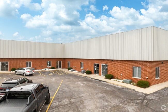
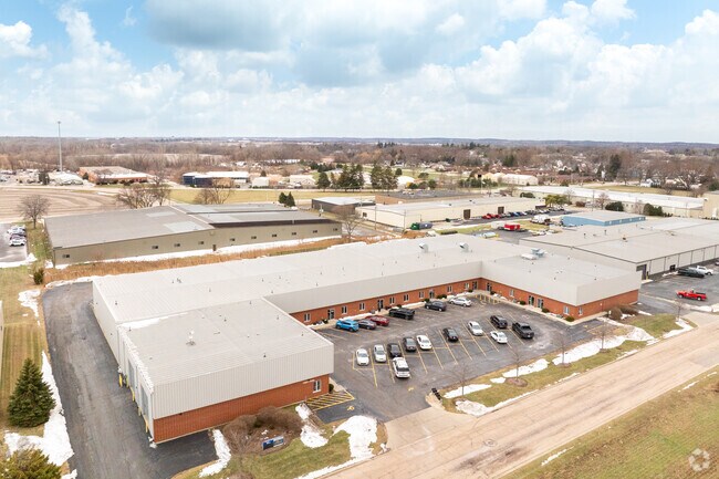
Property Record
11251 Kiley Dr, Huntley, IL 60142

Current Lease Availabilities
Property Detail
11251 Kiley Dr
18-28-476-015
DOC 2020R0028059 N 330FT S 703FT W 390FT E 1035.66FT SE1/4 SE1/4
Industrialgeneral
MCHENRY
B and X Area of moderate flood hazard, usually the area between the limits of the 100-year and 500-year floods.
Illinois
2024
2.95 AC
2024
McHenry County
871501
Chicago
45,000 SF
Chicago-Naperville-Elgin, IL-IN
NEARBY LISTINGS FOR SALE OR LEASE
DEMOGRAPHICS near 11251 Kiley Dr
1 mile
3 mile
5 mile
2025 Total Population
8,691
45,735
94,166
2030 Population
8,903
46,505
95,682
Pop Growth 2025-2030
+ 2.44%
+ 1.68%
+ 1.61%
Average Age
38
42
42
2025 Total Households
2,810
16,122
33,974
HH Growth 2025-2030
+ 2.53%
+ 1.76%
+ 1.66%
Median Household Inc
$113,383
$112,240
$112,347
Avg Household Size
3.00
2.80
2.70
2025 Avg HH Vehicles
2.00
2.00
2.00
Median Home Value
$344,091
$353,716
$349,845
Median Year Built
2001
2002
1999
Nearby Places
Map Layers
Map Styles
 Street
 Aerial
Layers
 Traffic
 Biking
Places
Listings with unknown addresses are not visible on the map
- Restaurants
- Banks
- Shops
- Fitness
- Groceries
PUBLIC TRANSPORTATION
AIRPORT
Chicago O'Hare International
Drive
Walk
Distance
Chicago O'Hare International
49 min
36.9 mi
Chicago/Rockford International
Drive
Walk
Distance
Chicago/Rockford International
61 min
45.0 mi
Nearby Properties
Address
Land Use
TOTAL SIZE
Lot Size
Zoning
Address
Land Use
TOTAL SIZE
Lot Size
Zoning
Address
Land Use
TOTAL SIZE
Lot Size
Zoning
Address
Land Use
TOTAL SIZE
Lot Size
Zoning
Address
Land Use
TOTAL SIZE
Lot Size
Zoning
Address
Land Use
TOTAL SIZE
Lot Size
Zoning
7.26 AC
Address
Land Use
TOTAL SIZE
Lot Size
Zoning
11.86 AC
Address
Land Use
TOTAL SIZE
Lot Size
Zoning
189,735 SF
21.85 AC
Address
Land Use
TOTAL SIZE
Lot Size
Zoning
3.50 AC
Address
Land Use
TOTAL SIZE
Lot Size
Zoning
Address
Land Use
TOTAL SIZE
Lot Size
Zoning
0.71 AC
Address
Land Use
TOTAL SIZE
Lot Size
Zoning
66,164 SF
9.90 AC
Address
Land Use
TOTAL SIZE
Lot Size
Zoning
9.28 AC
Address
Land Use
TOTAL SIZE
Lot Size
Zoning
8.23 AC
Address
Land Use
TOTAL SIZE
Lot Size
Zoning
57,813 SF
4.11 AC
Address
Land Use
TOTAL SIZE
Lot Size
Zoning
Address
Land Use
TOTAL SIZE
Lot Size
Zoning
11.15 AC
Address
Land Use
TOTAL SIZE
Lot Size
Zoning
92,850 SF
5 AC
Address
Land Use
TOTAL SIZE
Lot Size
Zoning
24,700 SF
3.08 AC
Address
Land Use
TOTAL SIZE
Lot Size
Zoning
3,144 SF
4.81 AC
Address
Land Use
TOTAL SIZE
Lot Size
Zoning
85,500 SF
7 AC
Address
Land Use
TOTAL SIZE
Lot Size
Zoning
2.55 AC
Address
Land Use
TOTAL SIZE
Lot Size
Zoning
22,200 SF
3.01 AC
Address
Land Use
TOTAL SIZE
Lot Size
Zoning
5.40 AC
Address
Land Use
TOTAL SIZE
Lot Size
Zoning
14,606 SF
2.14 AC
Address
Land Use
TOTAL SIZE
Lot Size
Zoning
0.27 AC
Address
Land Use
TOTAL SIZE
Lot Size
Zoning
24,157 SF
1.97 AC
Address
Land Use
TOTAL SIZE
Lot Size
Zoning
71,064 SF
7 AC
Address
Land Use
TOTAL SIZE
Lot Size
Zoning
65,235 SF
4.74 AC
Address
Land Use
TOTAL SIZE
Lot Size
Zoning
48,150 SF
3.42 AC
Address
Land Use
TOTAL SIZE
Lot Size
Zoning
9,440 SF
1.68 AC
The World's #1 Commercial Real Estate Marketplace
Connect with us
© 2026 CoStar Group
The information above has been obtained from sources believed reliable. While we do not doubt its accuracy we have not verified it and make no guarantee, warranty or representation about it. It is your responsibility to independently confirm its accuracy and completeness. Any projections, opinions, assumptions, or estimates used are for example only and do not represent the current or future performance of the property. The value of this transaction to you depends on tax and other factors which should be evaluated by your tax, financial, and legal advisors. You and your advisors should conduct a careful, independent investigation of the property to determine to your satisfaction the suitability of the property for your needs.