Property Record
11253 Pierce St, Riverside, CA 92505
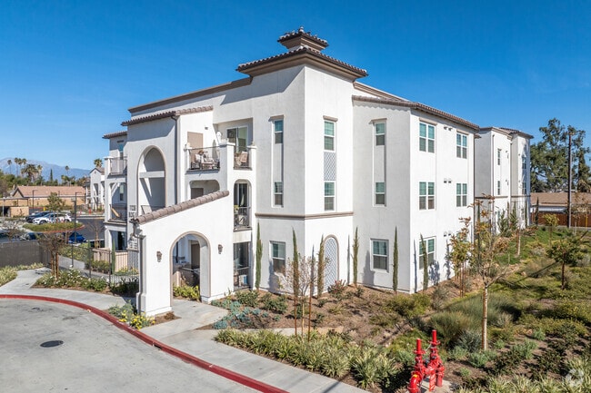


Property Detail
11253 Pierce St
Riverside-San Bernardino-Ontario, CA
ACRES 4.09000000 ACREAGEQUALCODE ML LOT 2-P LOTTYPE L BLOCK 60 MAPPLATB 007 MAPPLATP 066 SUBDIVISIONNAME TR NO.2 OF LA SIERRA
146-141-080
RIVERSIDE
Apartment
California
2024
2-p
2025
4.09 AC
040901
La Sierra
73,867 SF
Inland Empire (California)
NEARBY LISTINGS FOR SALE OR LEASE
-
-
View all Riverside listings for sale on LoopNet.com
DEMOGRAPHICS near 11253 Pierce St
1 mile
3 mile
5 mile
2025 Total Population
20,358
134,255
269,278
2030 Population
20,705
136,763
274,712
Pop Growth 2025-2030
+ 1.70%
+ 1.87%
+ 2.02%
Average Age
36
36
37
2025 Total Households
5,826
38,253
75,152
HH Growth 2025-2030
+ 1.32%
+ 1.39%
+ 1.56%
Median Household Inc
$90,383
$90,724
$95,510
Avg Household Size
3.30
3.30
3.30
2025 Avg HH Vehicles
2.00
2.00
2.00
Median Home Value
$667,577
$649,529
$669,151
Median Year Built
1983
1981
1980
Nearby Places
Map Layers
Map Styles
 Street
 Aerial
Layers
 Traffic
 Biking
Places
Listings with unknown addresses are not visible on the map
- Restaurants
- Banks
- Shops
- Fitness
- Groceries
PUBLIC TRANSPORTATION
COMMUTER RAIL
Riverside-La Sierra (91 Line - Southern California Regional Rail Authority (Metrolink), Inland Empire-Orange County Line - Southern California Regional Rail Authority (Metrolink))
Drive
Walk
Distance
Riverside-La Sierra (91 Line - Southern California Regional Rail Authority (Metrolink), Inland Empire-Orange County Line - Southern California Regional Rail Authority (Metrolink))
5 min
2.3 mi
Pedley (Riverside Line - Southern California Regional Rail Authority (Metrolink))
Drive
Walk
Distance
Pedley (Riverside Line - Southern California Regional Rail Authority (Metrolink))
13 min
6.4 mi
AIRPORT
Ontario International
Drive
Walk
Distance
Ontario International
28 min
17.0 mi
John Wayne/Orange County
Drive
Walk
Distance
John Wayne/Orange County
42 min
34.3 mi
Freight Ports
Port of Long Beach
Drive
Walk
Distance
Port of Long Beach
63 min
48.3 mi
Nearby Properties
Address
Land Use
TOTAL SIZE
Lot Size
Zoning
Address
Land Use
TOTAL SIZE
Lot Size
Zoning
1,662,289 SF
37.05 AC
Address
Land Use
TOTAL SIZE
Lot Size
Zoning
263,807 SF
13.14 AC
Address
Land Use
TOTAL SIZE
Lot Size
Zoning
167,068 SF
26.55 AC
Address
Land Use
TOTAL SIZE
Lot Size
Zoning
32,924 SF
24.04 AC
Address
Land Use
TOTAL SIZE
Lot Size
Zoning
76,546 SF
13.53 AC
R
Address
Land Use
TOTAL SIZE
Lot Size
Zoning
335,820 SF
15.18 AC
Address
Land Use
TOTAL SIZE
Lot Size
Zoning
71,440 SF
14.37 AC
Address
Land Use
TOTAL SIZE
Lot Size
Zoning
152,369 SF
5.38 AC
Address
Land Use
TOTAL SIZE
Lot Size
Zoning
20.08 AC
R020
Address
Land Use
TOTAL SIZE
Lot Size
Zoning
27,916 SF
8.50 AC
R3
Address
Land Use
TOTAL SIZE
Lot Size
Zoning
43,152 SF
6.76 AC
R3S2
Address
Land Use
TOTAL SIZE
Lot Size
Zoning
46,694 SF
7.16 AC
Address
Land Use
TOTAL SIZE
Lot Size
Zoning
14 AC
R1
Address
Land Use
TOTAL SIZE
Lot Size
Zoning
359,304 SF
8.86 AC
R3
Address
Land Use
TOTAL SIZE
Lot Size
Zoning
52,928 SF
9.69 AC
Address
Land Use
TOTAL SIZE
Lot Size
Zoning
25,808 SF
6.21 AC
Address
Land Use
TOTAL SIZE
Lot Size
Zoning
855,621 SF
46.79 AC
I
Address
Land Use
TOTAL SIZE
Lot Size
Zoning
14,068 SF
6.61 AC
R3
Address
Land Use
TOTAL SIZE
Lot Size
Zoning
4,562 SF
6.42 AC
Address
Land Use
TOTAL SIZE
Lot Size
Zoning
129,911 SF
6.10 AC
Address
Land Use
TOTAL SIZE
Lot Size
Zoning
116,787 SF
2.37 AC
Address
Land Use
TOTAL SIZE
Lot Size
Zoning
156,599 SF
6.27 AC
Address
Land Use
TOTAL SIZE
Lot Size
Zoning
73,538 SF
4.11 AC
R3150
Address
Land Use
TOTAL SIZE
Lot Size
Zoning
196,470 SF
11.43 AC
M1
Address
Land Use
TOTAL SIZE
Lot Size
Zoning
7.56 AC
R3
Address
Land Use
TOTAL SIZE
Lot Size
Zoning
63,718 SF
7.25 AC
R3
Address
Land Use
TOTAL SIZE
Lot Size
Zoning
100,000 SF
4.76 AC
CR
Address
Land Use
TOTAL SIZE
Lot Size
Zoning
88,402 SF
2.03 AC
Address
Land Use
TOTAL SIZE
Lot Size
Zoning
96,543 SF
3.34 AC
The World's #1 Commercial Real Estate Marketplace
Connect with us
© 2026 CoStar Group
The information above has been obtained from sources believed reliable. While we do not doubt its accuracy we have not verified it and make no guarantee, warranty or representation about it. It is your responsibility to independently confirm its accuracy and completeness. Any projections, opinions, assumptions, or estimates used are for example only and do not represent the current or future performance of the property. The value of this transaction to you depends on tax and other factors which should be evaluated by your tax, financial, and legal advisors. You and your advisors should conduct a careful, independent investigation of the property to determine to your satisfaction the suitability of the property for your needs.