Property Record
11255 Allen Rd, Southgate, MI 48195

NEARBY LISTINGS FOR SALE OR LEASE
-
-
View all Southgate listings for sale on LoopNet.com
Property Detail
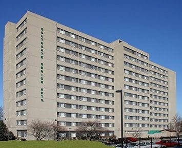
11255 Allen Rd
53-003-99-0010-708
Keystone
Commercialnec
*23G1B1A4A1* PT OF THE NW PART FRAC. SEC 23 T3S R10E DESC AS BEG S1D 08M 51SECW 696FT AND S88D 44M 39SECE 60FT FROM THE NW COR OF SAID SEC 23--TH S88D 44M 39SECE 140.00FT-TH N01D 08M 51SECE 120.00FT-TH S88D 44M 39SECE 113.00FT-TH S01D 15M 21SECW 21.0
X
Wayne
26163C0401E
Michigan
2025
2.80 AC
2025
Southgate
581600
Detroit
912 SF
Detroit-Warren-Dearborn, MI
DEMOGRAPHICS near 11255 Allen Rd
1 mile
3 mile
5 mile
2024 Total Population
7,271
101,272
245,628
2029 Population
7,002
97,049
235,820
Pop Growth 2024-2029
(3.70%)
(4.17%)
(3.99%)
Average Age
43
41
40
2024 Total Households
3,282
41,948
100,571
HH Growth 2024-2029
(3.60%)
(4.20%)
(4.03%)
Median Household Inc
$63,025
$67,016
$59,522
Avg Household Size
2.20
2.40
2.40
2024 Avg HH Vehicles
2.00
2.00
2.00
Median Home Value
$181,654
$150,200
$144,034
Median Year Built
1965
1957
1956
Nearby Places
Map Layers
Map Styles
 Street
 Aerial
Transit
 Traffic
 Biking
Places
Listings with unknown addresses are not visible on the map
- Restaurants
- Banks
- Shops
- Fitness
- Groceries
PUBLIC TRANSPORTATION
COMMUTER RAIL
Drive
Walk
Distance
16 min
7.1 mi
AIRPORT
Detroit Metro Wayne County
Drive
Walk
Distance
Detroit Metro Wayne County
22 min
10.4 mi
Windsor International
Drive
Walk
Distance
Windsor International
40 min
23.3 mi
Freight Ports
Drive
Walk
Distance
61 min
48.0 mi
Nearby Properties
Address
Land Use
TOTAL SIZE
Lot Size
Zoning
Address
Land Use
TOTAL SIZE
Lot Size
Zoning
553,004 SF
61.46 AC
B-2
Address
Land Use
TOTAL SIZE
Lot Size
Zoning
1,606,527 SF
126.47 AC
I-2
Address
Land Use
TOTAL SIZE
Lot Size
Zoning
357,640 SF
13.89 AC
C 6C
Address
Land Use
TOTAL SIZE
Lot Size
Zoning
217,726 SF
27.60 AC
B-2
Address
Land Use
TOTAL SIZE
Lot Size
Zoning
492,289 SF
34.84 AC
RM-1
Address
Land Use
TOTAL SIZE
Lot Size
Zoning
479,851 SF
16.90 AC
RM MULTI F
Address
Land Use
TOTAL SIZE
Lot Size
Zoning
125,898 SF
10.62 AC
B-2
Address
Land Use
TOTAL SIZE
Lot Size
Zoning
125,898 SF
10.62 AC
B-2
Address
Land Use
TOTAL SIZE
Lot Size
Zoning
3,261 SF
23.39 AC
RM MULTI F
Address
Land Use
TOTAL SIZE
Lot Size
Zoning
200,484 SF
48.86 AC
B-3
Address
Land Use
TOTAL SIZE
Lot Size
Zoning
214,489 SF
17.64 AC
RM-1
Address
Land Use
TOTAL SIZE
Lot Size
Zoning
287,791 SF
17.98 AC
RM MULTI F
Address
Land Use
TOTAL SIZE
Lot Size
Zoning
163,944 SF
17.51 AC
RM MULTI F
Address
Land Use
TOTAL SIZE
Lot Size
Zoning
236,908 SF
29.21 AC
B-2
Address
Land Use
TOTAL SIZE
Lot Size
Zoning
262,170 SF
15.27 AC
RM MULTI F
Address
Land Use
TOTAL SIZE
Lot Size
Zoning
356,200 SF
21.66 AC
I-2
Address
Land Use
TOTAL SIZE
Lot Size
Zoning
229,395 SF
15.46 AC
RM-1
Address
Land Use
TOTAL SIZE
Lot Size
Zoning
219,144 SF
24.53 AC
B-2
Address
Land Use
TOTAL SIZE
Lot Size
Zoning
32,767 SF
17.81 AC
RM-1
Address
Land Use
TOTAL SIZE
Lot Size
Zoning
144,724 SF
12.13 AC
B-2
Address
Land Use
TOTAL SIZE
Lot Size
Zoning
182,840 SF
11.70 AC
C 6C
Address
Land Use
TOTAL SIZE
Lot Size
Zoning
172,500 SF
6.52 AC
RM-1
Address
Land Use
TOTAL SIZE
Lot Size
Zoning
83,540 SF
2.90 AC
RM-2
Address
Land Use
TOTAL SIZE
Lot Size
Zoning
82,615 SF
15 AC
B-3
Address
Land Use
TOTAL SIZE
Lot Size
Zoning
193,650 SF
18.39 AC
Address
Land Use
TOTAL SIZE
Lot Size
Zoning
181,200 SF
19.33 AC
RM-1
Address
Land Use
TOTAL SIZE
Lot Size
Zoning
178,996 SF
15.06 AC
RM-1
Address
Land Use
TOTAL SIZE
Lot Size
Zoning
237,058 SF
2.82 AC
B-2
Address
Land Use
TOTAL SIZE
Lot Size
Zoning
98,356 SF
7.83 AC
B-2
The World's #1 Commercial Real Estate Marketplace
Connect with us
© 2026 CoStar Group
The information above has been obtained from sources believed reliable. While we do not doubt its accuracy we have not verified it and make no guarantee, warranty or representation about it. It is your responsibility to independently confirm its accuracy and completeness. Any projections, opinions, assumptions, or estimates used are for example only and do not represent the current or future performance of the property. The value of this transaction to you depends on tax and other factors which should be evaluated by your tax, financial, and legal advisors. You and your advisors should conduct a careful, independent investigation of the property to determine to your satisfaction the suitability of the property for your needs.