Property Record
11276 1St Ave Nw, Grand Rapids, MI 49534
NEARBY LISTINGS FOR SALE OR LEASE
Property Detail
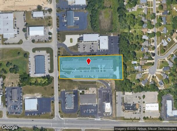
11276 1St Ave Nw
Grand Rapids-Wyoming, MI
Tallmadge Industrial Aprk
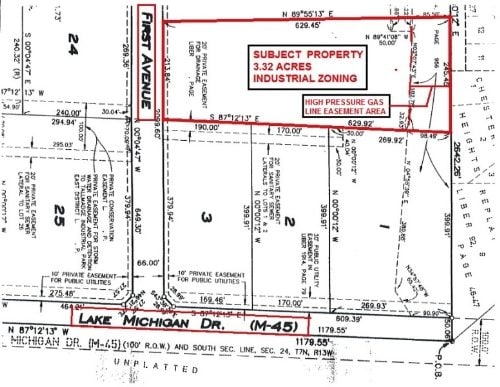
70-10-24-485-013
LOT 4 TALLMADGE INDUSTRIAL PARK
Multifamilydwelling
Ottawa
X
Michigan
26081C0385D
4
2025
3.32 AC
2025
Northern Ottawa County
021401
West Michigan
37,268 SF
DEMOGRAPHICS near 11276 1St Ave Nw
1 Mile
3 Mile
5 Mile
2024 Total Population
4,990
28,640
82,511
2029 Population
5,210
29,414
84,027
Pop Growth 2024-2029
+ 4.41%
+ 2.70%
+ 1.84%
Average Age
39
40
39
2024 Total Households
1,853
11,687
32,484
HH Growth 2024-2029
+ 4.32%
+ 2.53%
+ 1.82%
Median Household Inc
$74,999
$74,895
$71,447
Avg Household Size
2.60
2.40
2.40
2024 Avg HH Vehicles
2.00
2.00
2.00
Median Home Value
$231,368
$254,398
$230,800
Median Year Built
1993
1985
1971
Nearby Places
Map Layers
Map Styles
 Street
 Aerial
- Restaurants
- Banks
- Shops
- Fitness
- Groceries
PUBLIC TRANSPORTATION
COMMUTER RAIL
DRIVE
WALK
Distance
14 min
6.8 mi
AIRPORT
Gerald R Ford International
DRIVE
WALK
Distance
Gerald R Ford International
33 min
20.9 mi
Nearby Properties
Address
Land Use
TOTAL SIZE
Lot Size
Zoning
Address
Land Use
TOTAL SIZE
Lot Size
Zoning
390,682 SF
47.73 AC
ARM - MULT
Address
Land Use
TOTAL SIZE
Lot Size
Zoning
389,181 SF
51.01 AC
RPUD - 2
Address
Land Use
TOTAL SIZE
Lot Size
Zoning
32.89 AC
TN-LDR
Address
Land Use
TOTAL SIZE
Lot Size
Zoning
343,973 SF
29.15 AC
MON-LDR
Address
Land Use
TOTAL SIZE
Lot Size
Zoning
245,620 SF
20.13 AC
RPUD - 2
Address
Land Use
TOTAL SIZE
Lot Size
Zoning
209,522 SF
27.89 AC
CPUD
Address
Land Use
TOTAL SIZE
Lot Size
Zoning
147,232 SF
18.42 AC
ARM - MULT
Address
Land Use
TOTAL SIZE
Lot Size
Zoning
107,800 SF
13.29 AC
CPUD
Address
Land Use
TOTAL SIZE
Lot Size
Zoning
140,841 SF
8.96 AC
Address
Land Use
TOTAL SIZE
Lot Size
Zoning
85,472 SF
12.17 AC
ARM - MULT
Address
Land Use
TOTAL SIZE
Lot Size
Zoning
123,668 SF
Address
Land Use
TOTAL SIZE
Lot Size
Zoning
78,872 SF
3.09 AC
MON-LDR
Address
Land Use
TOTAL SIZE
Lot Size
Zoning
88,113 SF
12.50 AC
Address
Land Use
TOTAL SIZE
Lot Size
Zoning
4.80 AC
Address
Land Use
TOTAL SIZE
Lot Size
Zoning
53,653 SF
1.81 AC
MON-MDR
Address
Land Use
TOTAL SIZE
Lot Size
Zoning
51,232 SF
5.04 AC
MCN-C
Address
Land Use
TOTAL SIZE
Lot Size
Zoning
1,992 SF
48.64 AC
RMT
Address
Land Use
TOTAL SIZE
Lot Size
Zoning
53,600 SF
Address
Land Use
TOTAL SIZE
Lot Size
Zoning
67,821 SF
4.95 AC
Address
Land Use
TOTAL SIZE
Lot Size
Zoning
65,562 SF
8.18 AC
Address
Land Use
TOTAL SIZE
Lot Size
Zoning
2,173 SF
40.87 AC
RMT
Address
Land Use
TOTAL SIZE
Lot Size
Zoning
78,451 SF
4.57 AC
Address
Land Use
TOTAL SIZE
Lot Size
Zoning
47,178 SF
2.64 AC
Address
Land Use
TOTAL SIZE
Lot Size
Zoning
45,000 SF
2.31 AC
Address
Land Use
TOTAL SIZE
Lot Size
Zoning
13,255 SF
1.36 AC
CPUD
Address
Land Use
TOTAL SIZE
Lot Size
Zoning
62,978 SF
7.58 AC
Address
Land Use
TOTAL SIZE
Lot Size
Zoning
19,078 SF
3.46 AC
CPUD
Address
Land Use
TOTAL SIZE
Lot Size
Zoning
77,750 SF
5.46 AC
IPUD
Address
Land Use
TOTAL SIZE
Lot Size
Zoning
36,975 SF
The World's #1 Commercial Real Estate Marketplace
Connect with us
© 2026 CoStar Group
The information above has been obtained from sources believed reliable. While we do not doubt its accuracy we have not verified it and make no guarantee, warranty or representation about it. It is your responsibility to independently confirm its accuracy and completeness. Any projections, opinions, assumptions, or estimates used are for example only and do not represent the current or future performance of the property. The value of this transaction to you depends on tax and other factors which should be evaluated by your tax, financial, and legal advisors. You and your advisors should conduct a careful, independent investigation of the property to determine to your satisfaction the suitability of the property for your needs.