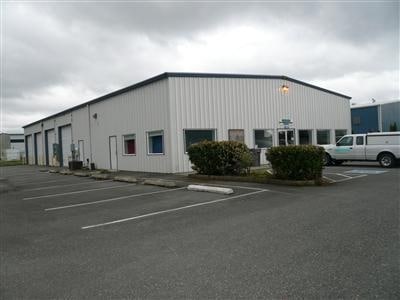
Property Record
1128 Dale Ln, Mount Vernon, WA 98274

NEARBY LISTINGS FOR SALE OR LEASE
Property Detail
1128 Dale Ln
Other Market Areas
Skagit Cnty Short 91-025
Mount Vernon-Anacortes, WA
(1.7500 AC) DK 3: DR 17: PARCEL A OF SHORT PLAT #91-025 AF#9105290007 PTN OF SE1/4 NW1/4, SECTION 32, TOWNSHIP 34 NORTH, RANGE 4 EAST, W.M. FORMERLY A PTN OF TRACT 2 SHORT PLAT #16-85 AF#8506260063
P29557
Skagit
Commercialnec
Washington
2025
a
2025
1.75 AC
952600
Bellingham/Northwest
6,600 SF
DEMOGRAPHICS near 1128 Dale Ln
1 Mile
3 Mile
5 Mile
2024 Total Population
1,924
27,603
48,163
2029 Population
2,001
28,744
50,314
Pop Growth 2024-2029
+ 4.00%
+ 4.13%
+ 4.47%
Average Age
43
40
40
2024 Total Households
712
10,400
17,798
HH Growth 2024-2029
+ 4.07%
+ 4.26%
+ 4.58%
Median Household Inc
$85,912
$62,902
$67,027
Avg Household Size
2.60
2.60
2.60
2024 Avg HH Vehicles
3.00
2.00
2.00
Median Home Value
$498,845
$418,641
$428,421
Median Year Built
1979
1979
1987
Nearby Places
Map Layers
Map Styles
 Street
 Aerial
- Restaurants
- Banks
- Shops
- Fitness
- Groceries
PUBLIC TRANSPORTATION
COMMUTER RAIL
Mount Vernon Amtrak Station (Amtrak Cascades - Amtrak)
DRIVE
WALK
Distance
Mount Vernon Amtrak Station (Amtrak Cascades - Amtrak)
4 min
2.1 mi
AIRPORT
Bellingham International
DRIVE
WALK
Distance
Bellingham International
44 min
34.4 mi
Freight Ports
Port of Anacortes
DRIVE
WALK
Distance
Port of Anacortes
30 min
19.1 mi
Nearby Properties
Address
Land Use
TOTAL SIZE
Lot Size
Zoning
Address
Land Use
TOTAL SIZE
Lot Size
Zoning
404,511 SF
9.01 AC
Address
Land Use
TOTAL SIZE
Lot Size
Zoning
105,000 SF
1 AC
Address
Land Use
TOTAL SIZE
Lot Size
Zoning
Address
Land Use
TOTAL SIZE
Lot Size
Zoning
138,226 SF
30.55 AC
Address
Land Use
TOTAL SIZE
Lot Size
Zoning
2,468 SF
0.68 AC
Address
Land Use
TOTAL SIZE
Lot Size
Zoning
52,239 SF
5.50 AC
Address
Land Use
TOTAL SIZE
Lot Size
Zoning
51,416 SF
Address
Land Use
TOTAL SIZE
Lot Size
Zoning
138,353 SF
10 AC
Address
Land Use
TOTAL SIZE
Lot Size
Zoning
Address
Land Use
TOTAL SIZE
Lot Size
Zoning
55,326 SF
9.12 AC
Address
Land Use
TOTAL SIZE
Lot Size
Zoning
42,634 SF
15.86 AC
Address
Land Use
TOTAL SIZE
Lot Size
Zoning
53,510 SF
3.67 AC
Address
Land Use
TOTAL SIZE
Lot Size
Zoning
77,090 SF
12.60 AC
Address
Land Use
TOTAL SIZE
Lot Size
Zoning
Address
Land Use
TOTAL SIZE
Lot Size
Zoning
60,251 SF
8.09 AC
Address
Land Use
TOTAL SIZE
Lot Size
Zoning
30,000 SF
2 AC
Address
Land Use
TOTAL SIZE
Lot Size
Zoning
51,416 SF
Address
Land Use
TOTAL SIZE
Lot Size
Zoning
2,880 SF
9.72 AC
Address
Land Use
TOTAL SIZE
Lot Size
Zoning
43,047 SF
5.77 AC
Address
Land Use
TOTAL SIZE
Lot Size
Zoning
57,231 SF
10.14 AC
Address
Land Use
TOTAL SIZE
Lot Size
Zoning
54,108 SF
44 SF
Address
Land Use
TOTAL SIZE
Lot Size
Zoning
53,000 SF
0.10 AC
Address
Land Use
TOTAL SIZE
Lot Size
Zoning
50,801 SF
44 SF
Address
Land Use
TOTAL SIZE
Lot Size
Zoning
12,590 SF
7.54 AC
Address
Land Use
TOTAL SIZE
Lot Size
Zoning
6,020 SF
6.21 AC
Address
Land Use
TOTAL SIZE
Lot Size
Zoning
14.77 AC
Address
Land Use
TOTAL SIZE
Lot Size
Zoning
34,794 SF
2.22 AC
Address
Land Use
TOTAL SIZE
Lot Size
Zoning
9,139 SF
1.15 AC
Address
Land Use
TOTAL SIZE
Lot Size
Zoning
44,000 SF
0.18 AC
Address
Land Use
TOTAL SIZE
Lot Size
Zoning
12,246 SF
215.76 AC
The World's #1 Commercial Real Estate Marketplace
Connect with us
© 2026 CoStar Group
The information above has been obtained from sources believed reliable. While we do not doubt its accuracy we have not verified it and make no guarantee, warranty or representation about it. It is your responsibility to independently confirm its accuracy and completeness. Any projections, opinions, assumptions, or estimates used are for example only and do not represent the current or future performance of the property. The value of this transaction to you depends on tax and other factors which should be evaluated by your tax, financial, and legal advisors. You and your advisors should conduct a careful, independent investigation of the property to determine to your satisfaction the suitability of the property for your needs.