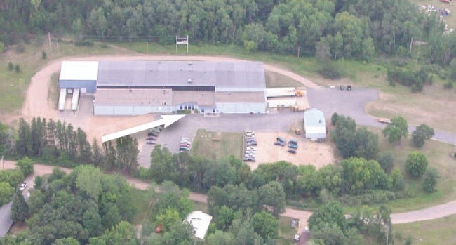
Property Record
11287 Ash Ave, Brainerd, MN 56401

Property Detail
11287 Ash Ave
Brainerd, MN
OUTLOTS 33 & 34, EXCEPT THAT PART OF OUTLOT 33 CONVEYED TO STATE OF MINN. SHOWN AS PARCEL 222 ON MIN
81112000933X009
Crow Wing
Industrialgeneral
Minnesota
B and X Area of moderate flood hazard, usually the area between the limits of the 100-year and 500-year floods.
33
2026
10.33 AC
2025
Minnesota Central Area
951000
Other Market Areas
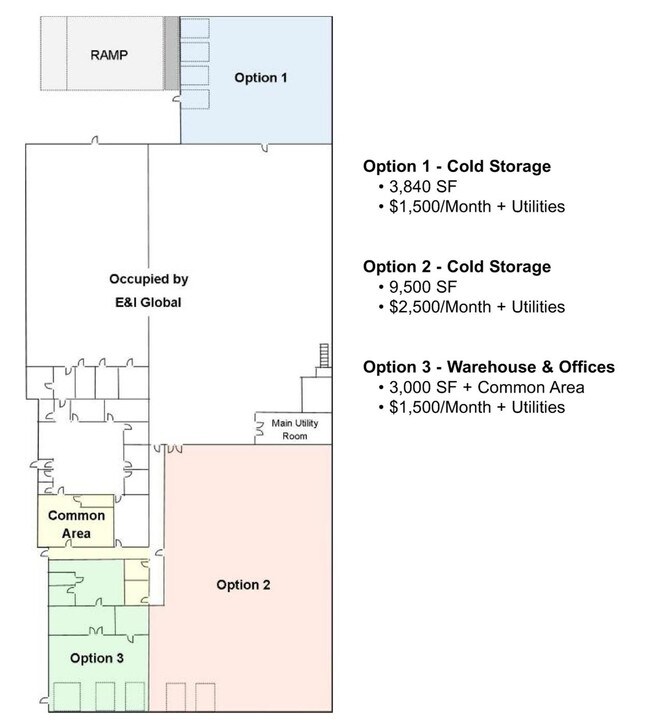
38,338 SF
NEARBY LISTINGS FOR SALE OR LEASE
DEMOGRAPHICS near 11287 Ash Ave
1 mile
3 mile
5 mile
2025 Total Population
1,810
12,792
19,410
2030 Population
1,771
12,508
19,104
Pop Growth 2025-2030
(2.15%)
(2.22%)
(1.58%)
Average Age
40
39
40
2025 Total Households
741
5,263
8,019
HH Growth 2025-2030
(2.16%)
(2.43%)
(1.73%)
Median Household Inc
$70,185
$57,646
$59,522
Avg Household Size
2.40
2.20
2.20
2025 Avg HH Vehicles
2.00
2.00
2.00
Median Home Value
$224,193
$203,482
$244,162
Median Year Built
1973
1973
1980
Nearby Places
Map Layers
Map Styles
 Street
 Aerial
Layers
 Traffic
 Biking
Places
Listings with unknown addresses are not visible on the map
- Restaurants
- Banks
- Shops
- Fitness
- Groceries
SALE & LEASE HISTORY
LISTING DATE
SALE/LEASE

Sep 25, 2016
For Lease
Sep 24, 2016
For Sale
Nearby Properties
Address
Land Use
TOTAL SIZE
Lot Size
Zoning
Address
Land Use
TOTAL SIZE
Lot Size
Zoning
3,829 SF
1.04 AC
Address
Land Use
TOTAL SIZE
Lot Size
Zoning
186,000 SF
8.71 AC
Address
Land Use
TOTAL SIZE
Lot Size
Zoning
229,123 SF
11.84 AC
Address
Land Use
TOTAL SIZE
Lot Size
Zoning
31,074 SF
638.70 AC
Address
Land Use
TOTAL SIZE
Lot Size
Zoning
128,295 SF
2.08 AC
Address
Land Use
TOTAL SIZE
Lot Size
Zoning
110,624 SF
5.62 AC
Address
Land Use
TOTAL SIZE
Lot Size
Zoning
61,704 SF
16.09 AC
Address
Land Use
TOTAL SIZE
Lot Size
Zoning
Address
Land Use
TOTAL SIZE
Lot Size
Zoning
25,104 SF
18.43 AC
Address
Land Use
TOTAL SIZE
Lot Size
Zoning
113,024 SF
2.96 AC
Address
Land Use
TOTAL SIZE
Lot Size
Zoning
83,078 SF
9.71 AC
Address
Land Use
TOTAL SIZE
Lot Size
Zoning
90,147 SF
12.93 AC
Address
Land Use
TOTAL SIZE
Lot Size
Zoning
54,164 SF
5.65 AC
Address
Land Use
TOTAL SIZE
Lot Size
Zoning
87,007 SF
4.98 AC
Address
Land Use
TOTAL SIZE
Lot Size
Zoning
47,378 SF
1.56 AC
Address
Land Use
TOTAL SIZE
Lot Size
Zoning
844 SF
31.98 AC
Address
Land Use
TOTAL SIZE
Lot Size
Zoning
48,324 SF
3.63 AC
Address
Land Use
TOTAL SIZE
Lot Size
Zoning
34,033 SF
9.81 AC
Address
Land Use
TOTAL SIZE
Lot Size
Zoning
100,000 SF
51.22 AC
Address
Land Use
TOTAL SIZE
Lot Size
Zoning
147,000 SF
41.18 AC
Address
Land Use
TOTAL SIZE
Lot Size
Zoning
16,392 SF
26.78 AC
Address
Land Use
TOTAL SIZE
Lot Size
Zoning
37,996 SF
6.32 AC
Address
Land Use
TOTAL SIZE
Lot Size
Zoning
480 SF
22.30 AC
Address
Land Use
TOTAL SIZE
Lot Size
Zoning
29,100 SF
2.35 AC
Address
Land Use
TOTAL SIZE
Lot Size
Zoning
30,040 SF
2.75 AC
Address
Land Use
TOTAL SIZE
Lot Size
Zoning
33,876 SF
0.97 AC
Address
Land Use
TOTAL SIZE
Lot Size
Zoning
29,158 SF
12.87 AC
Address
Land Use
TOTAL SIZE
Lot Size
Zoning
10,872 SF
0.48 AC
Address
Land Use
TOTAL SIZE
Lot Size
Zoning
19,182 SF
0.34 AC
Address
Land Use
TOTAL SIZE
Lot Size
Zoning
27,558 SF
2.57 AC
The World's #1 Commercial Real Estate Marketplace
Connect with us
© 2026 CoStar Group
The information above has been obtained from sources believed reliable. While we do not doubt its accuracy we have not verified it and make no guarantee, warranty or representation about it. It is your responsibility to independently confirm its accuracy and completeness. Any projections, opinions, assumptions, or estimates used are for example only and do not represent the current or future performance of the property. The value of this transaction to you depends on tax and other factors which should be evaluated by your tax, financial, and legal advisors. You and your advisors should conduct a careful, independent investigation of the property to determine to your satisfaction the suitability of the property for your needs.