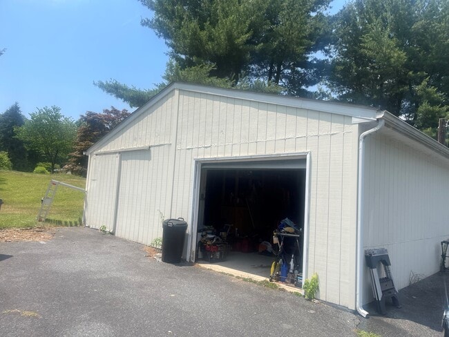
Property Record
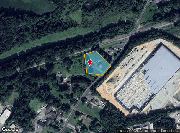
1129 Clayton Rd, Joppa, MD 21085
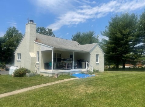
This Property Is For Sale
NEARBY LISTINGS FOR SALE OR LEASE
Property Detail
1129 Clayton Rd
01-073710
Joppa
Sfr
LOT 1.201 ACRES 1129 CLAYTON ROAD JOPPA
X
Harford
2400100315H
Maryland
2025
1.20 AC
2025
Outlying Harford County
301301
Baltimore
1,469 SF
Baltimore-Columbia-Towson, MD
DEMOGRAPHICS near 1129 Clayton Rd
1 mile
3 mile
5 mile
2024 Total Population
6,150
48,822
96,667
2029 Population
6,303
49,969
98,646
Pop Growth 2024-2029
+ 2.49%
+ 2.35%
+ 2.05%
Average Age
38
39
40
2024 Total Households
2,320
18,709
35,968
HH Growth 2024-2029
+ 2.46%
+ 2.33%
+ 2.04%
Median Household Inc
$64,921
$81,188
$92,685
Avg Household Size
2.60
2.50
2.60
2024 Avg HH Vehicles
2.00
2.00
2.00
Median Home Value
$139,875
$246,790
$295,619
Median Year Built
1985
1983
1987
Nearby Places
Map Layers
Map Styles
 Street
 Aerial
Transit
 Traffic
 Biking
Places
Listings with unknown addresses are not visible on the map
- Restaurants
- Banks
- Shops
- Fitness
- Groceries
PUBLIC TRANSPORTATION
COMMUTER RAIL
Edgewood (PENN - WASHINGTON - Maryland Area Regional Commuter Trains (The MARC), Penn Line - Maryland Area Regional Commuter Trains (The MARC))
Drive
Walk
Distance
Edgewood (PENN - WASHINGTON - Maryland Area Regional Commuter Trains (The MARC), Penn Line - Maryland Area Regional Commuter Trains (The MARC))
8 min
3.9 mi
AIRPORT
Baltimore/Washington International Thurgood Marshall
Drive
Walk
Distance
Baltimore/Washington International Thurgood Marshall
44 min
30.7 mi
Freight Ports
Port of Baltimore
Drive
Walk
Distance
Port of Baltimore
31 min
22.1 mi
Nearby Properties
Address
Land Use
TOTAL SIZE
Lot Size
Zoning
Address
Land Use
TOTAL SIZE
Lot Size
Zoning
5,501.68 AC
R1
Address
Land Use
TOTAL SIZE
Lot Size
Zoning
97,619 SF
99.88 AC
R2
Address
Land Use
TOTAL SIZE
Lot Size
Zoning
15,250 SF
17.86 AC
CI
Address
Land Use
TOTAL SIZE
Lot Size
Zoning
266,913 SF
28.35 AC
R4
Address
Land Use
TOTAL SIZE
Lot Size
Zoning
253,842 SF
69.33 AC
R2
Address
Land Use
TOTAL SIZE
Lot Size
Zoning
44,475 SF
86.10 AC
R2
Address
Land Use
TOTAL SIZE
Lot Size
Zoning
822,410 SF
44.24 AC
GI
Address
Land Use
TOTAL SIZE
Lot Size
Zoning
996,030 SF
70.22 AC
GI
Address
Land Use
TOTAL SIZE
Lot Size
Zoning
59,724 SF
20.79 AC
C1
Address
Land Use
TOTAL SIZE
Lot Size
Zoning
212,760 SF
27.85 AC
GI
Address
Land Use
TOTAL SIZE
Lot Size
Zoning
246,560 SF
14.57 AC
LI
Address
Land Use
TOTAL SIZE
Lot Size
Zoning
61,350 SF
20 AC
B2
Address
Land Use
TOTAL SIZE
Lot Size
Zoning
124,268 SF
10.85 AC
R3
Address
Land Use
TOTAL SIZE
Lot Size
Zoning
1,690 SF
76.45 AC
R4
Address
Land Use
TOTAL SIZE
Lot Size
Zoning
116,822 SF
13.42 AC
CI
Address
Land Use
TOTAL SIZE
Lot Size
Zoning
109,398 SF
11.36 AC
CI
Address
Land Use
TOTAL SIZE
Lot Size
Zoning
200 AC
R4
Address
Land Use
TOTAL SIZE
Lot Size
Zoning
97,985 SF
12.12 AC
CI
Address
Land Use
TOTAL SIZE
Lot Size
Zoning
134,875 SF
40.88 AC
CI
Address
Land Use
TOTAL SIZE
Lot Size
Zoning
113,173 SF
17.04 AC
CI
Address
Land Use
TOTAL SIZE
Lot Size
Zoning
94,312 SF
14.40 AC
LI
Address
Land Use
TOTAL SIZE
Lot Size
Zoning
18.51 AC
R3
Address
Land Use
TOTAL SIZE
Lot Size
Zoning
255,464 SF
19.15 AC
GI
Address
Land Use
TOTAL SIZE
Lot Size
Zoning
191 AC
R4
Address
Land Use
TOTAL SIZE
Lot Size
Zoning
49,131 SF
14.39 AC
CI
Address
Land Use
TOTAL SIZE
Lot Size
Zoning
51,449 SF
32.85 AC
R4
Address
Land Use
TOTAL SIZE
Lot Size
Zoning
142,311 SF
24.28 AC
GI
Address
Land Use
TOTAL SIZE
Lot Size
Zoning
150 AC
R4
Address
Land Use
TOTAL SIZE
Lot Size
Zoning
150 AC
R4
Address
Land Use
TOTAL SIZE
Lot Size
Zoning
116,650 SF
47.59 AC
B3
The World's #1 Commercial Real Estate Marketplace
Connect with us
© 2026 CoStar Group
The information above has been obtained from sources believed reliable. While we do not doubt its accuracy we have not verified it and make no guarantee, warranty or representation about it. It is your responsibility to independently confirm its accuracy and completeness. Any projections, opinions, assumptions, or estimates used are for example only and do not represent the current or future performance of the property. The value of this transaction to you depends on tax and other factors which should be evaluated by your tax, financial, and legal advisors. You and your advisors should conduct a careful, independent investigation of the property to determine to your satisfaction the suitability of the property for your needs.