Property Record
11290 W State Road 84, Davie, FL 33325
NEARBY LISTINGS FOR SALE OR LEASE
Property Detail
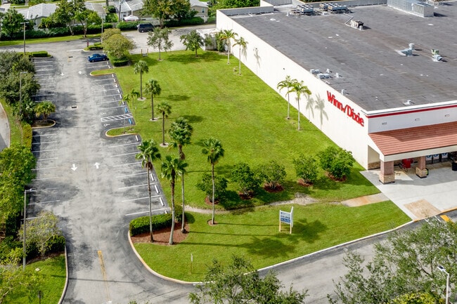
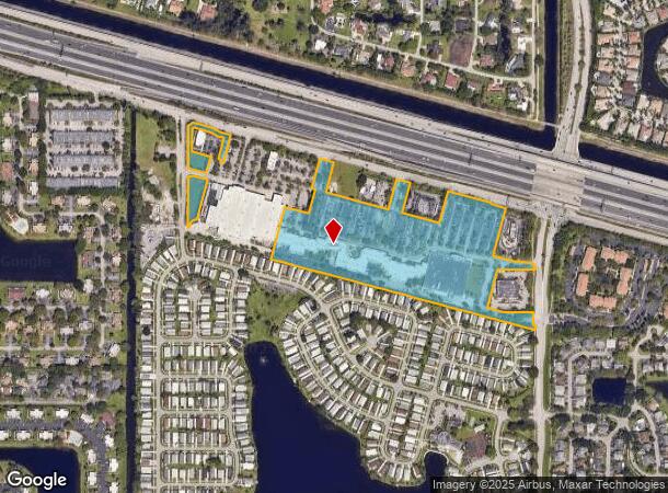
11290 W State Road 84
50-40-12-40-0010
The Plaza 125-33 B
Regionalshoppingcenterormallwithanchorstore
THE PLAZA 125-33 B PARCEL A LESS WALGREENS, MCDONALDS PARCEL, OR 35346/1602 BCR;TOG WITH PARCEL A OF THE PLAZA II 126-24 B LESS I-FLY DAVIE, RUBY TUESDAYS & LOWES LEASED PARCEL; ALL LESS PARCEL 113 AS DESC IN ORT RECORDED IN OR 41786/1972 BCR
AH
Broward
12011C0535J
Florida
2024
20.57 AC
2025
Southwest Broward
070205
South Florida
150,563 SF
Fort Lauderdale-Pompano Beach-Deerfield Beach, FL
DEMOGRAPHICS near 11290 W State Road 84
1 Mile
3 Mile
5 Mile
2024 Total Population
10,516
97,999
261,593
2029 Population
10,373
97,171
258,513
Pop Growth 2024-2029
(1.36%)
(0.84%)
(1.18%)
Average Age
41
40
41
2024 Total Households
3,649
37,052
98,531
HH Growth 2024-2029
(1.95%)
(1.18%)
(1.55%)
Median Household Inc
$105,818
$89,857
$81,923
Avg Household Size
2.80
2.50
2.50
2024 Avg HH Vehicles
2.00
2.00
2.00
Median Home Value
$389,594
$411,318
$375,167
Median Year Built
1990
1988
1984
Nearby Places
- Restaurants
- Banks
- Shops
- Fitness
- Groceries
PUBLIC TRANSPORTATION
COMMUTER RAIL
Fort Lauderdale (Tri-County Commuter - South Florida Regional Transportation Authority (Tri-Rail))
DRIVE
WALK
Distance
Fort Lauderdale (Tri-County Commuter - South Florida Regional Transportation Authority (Tri-Rail))
19 min
9.4 mi
AIRPORT
Fort Lauderdale/Hollywood International
DRIVE
WALK
Distance
Fort Lauderdale/Hollywood International
18 min
10.7 mi
Miami International
DRIVE
WALK
Distance
Miami International
41 min
30.4 mi
Freight Ports
Port Everglades
DRIVE
WALK
Distance
Port Everglades
17 min
12.7 mi
Nearby Properties
Address
Land Use
TOTAL SIZE
Lot Size
Zoning
Address
Land Use
TOTAL SIZE
Lot Size
Zoning
574,019 SF
44.58 AC
RM-10N
Address
Land Use
TOTAL SIZE
Lot Size
Zoning
796,660 SF
40.90 AC
B-4
Address
Land Use
TOTAL SIZE
Lot Size
Zoning
632,250 SF
34.15 AC
PRD-11.6Q
Address
Land Use
TOTAL SIZE
Lot Size
Zoning
458,854 SF
30.97 AC
PRD-15Q **
Address
Land Use
TOTAL SIZE
Lot Size
Zoning
627,368 SF
4.33 AC
PRD-21Q
Address
Land Use
TOTAL SIZE
Lot Size
Zoning
486,920 SF
22.16 AC
PUD
Address
Land Use
TOTAL SIZE
Lot Size
Zoning
613,363 SF
6.24 AC
B-7Q
Address
Land Use
TOTAL SIZE
Lot Size
Zoning
337,553 SF
39.13 AC
RM-10
Address
Land Use
TOTAL SIZE
Lot Size
Zoning
497,004 SF
4.46 AC
M-PM
Address
Land Use
TOTAL SIZE
Lot Size
Zoning
333,099 SF
9.03 AC
PRD-10Q
Address
Land Use
TOTAL SIZE
Lot Size
Zoning
527,086 SF
2.34 AC
M-PM
Address
Land Use
TOTAL SIZE
Lot Size
Zoning
439,908 SF
13.54 AC
OP-P
Address
Land Use
TOTAL SIZE
Lot Size
Zoning
312,067 SF
20.94 AC
PRD-15Q
Address
Land Use
TOTAL SIZE
Lot Size
Zoning
445,798 SF
11.80 AC
OP-P
Address
Land Use
TOTAL SIZE
Lot Size
Zoning
234,496 SF
3.07 AC
M-PM
Address
Land Use
TOTAL SIZE
Lot Size
Zoning
247,934 SF
17.05 AC
B-4
Address
Land Use
TOTAL SIZE
Lot Size
Zoning
365,027 SF
38.55 AC
CF
Address
Land Use
TOTAL SIZE
Lot Size
Zoning
405,695 SF
10.08 AC
M-PM
Address
Land Use
TOTAL SIZE
Lot Size
Zoning
248,539 SF
0.13 AC
M-PM
Address
Land Use
TOTAL SIZE
Lot Size
Zoning
242,841 SF
17.21 AC
M-PM
Address
Land Use
TOTAL SIZE
Lot Size
Zoning
568,182 SF
6.90 AC
B-4
Address
Land Use
TOTAL SIZE
Lot Size
Zoning
264,127 SF
24.02 AC
B-3
Address
Land Use
TOTAL SIZE
Lot Size
Zoning
264,230 SF
24.07 AC
PRD-12.54Q
Address
Land Use
TOTAL SIZE
Lot Size
Zoning
210,856 SF
5.93 AC
B-7Q
Address
Land Use
TOTAL SIZE
Lot Size
Zoning
188,466 SF
0.73 AC
M-PM
Address
Land Use
TOTAL SIZE
Lot Size
Zoning
461,576 SF
27.86 AC
M-PM
Address
Land Use
TOTAL SIZE
Lot Size
Zoning
289,650 SF
25.39 AC
M-PM
Address
Land Use
TOTAL SIZE
Lot Size
Zoning
327,367 SF
1.89 AC
M-PM
Address
Land Use
TOTAL SIZE
Lot Size
Zoning
289,558 SF
8.93 AC
PRD-25Q
Address
Land Use
TOTAL SIZE
Lot Size
Zoning
390,022 SF
22.48 AC
I-1
The World's #1 Commercial Real Estate Marketplace
Connect with us
© 2025 CoStar Group
The information above has been obtained from sources believed reliable. While we do not doubt its accuracy we have not verified it and make no guarantee, warranty or representation about it. It is your responsibility to independently confirm its accuracy and completeness. Any projections, opinions, assumptions, or estimates used are for example only and do not represent the current or future performance of the property. The value of this transaction to you depends on tax and other factors which should be evaluated by your tax, financial, and legal advisors. You and your advisors should conduct a careful, independent investigation of the property to determine to your satisfaction the suitability of the property for your needs.