Property Record
113 3Rd St E, Carver, MN 55315
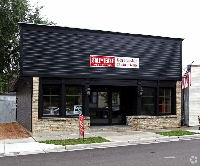

Property Detail
113 3Rd St E
Minneapolis-St. Paul-Bloomington, MN-WI
THAT P/O LOT 3 BLK 17 WHICH LIES NELY OF A LINE DRAWN FROM A PT ON NWLY LINE OF LOT 3 42'
20.0500351
Carver
Officebuilding
Minnesota
AE The base floodplain where base flood elevations are provided. AE Zones are now used on new format FIRMs instead of A1-A30 Zones.
3
2025
0.07 AC
2025
Carver County Outlying
091100
Minneapolis/St Paul
1,350 SF
NEARBY LISTINGS FOR SALE OR LEASE
DEMOGRAPHICS near 113 3Rd St E
1 mile
3 mile
5 mile
2024 Total Population
3,442
16,041
47,236
2029 Population
3,641
16,944
49,307
Pop Growth 2024-2029
+ 5.78%
+ 5.63%
+ 4.38%
Average Age
37
37
39
2024 Total Households
1,136
5,651
16,808
HH Growth 2024-2029
+ 6.07%
+ 5.68%
+ 4.44%
Median Household Inc
$138,285
$125,593
$116,923
Avg Household Size
3.00
2.80
2.70
2024 Avg HH Vehicles
2.00
2.00
2.00
Median Home Value
$408,033
$409,650
$399,680
Median Year Built
2003
2000
1997
Nearby Places
Map Layers
Map Styles
 Street
 Aerial
Transit
 Traffic
 Biking
Places
Listings with unknown addresses are not visible on the map
- Restaurants
- Banks
- Shops
- Fitness
- Groceries
PUBLIC TRANSPORTATION
AIRPORT
Minneapolis-St Paul International/Wold-Chamberlain
Drive
Walk
Distance
Minneapolis-St Paul International/Wold-Chamberlain
36 min
25.6 mi
SALE & LEASE HISTORY
LISTING DATE
SALE/LEASE

Jan 18, 2017
For Lease
Nearby Properties
Address
Land Use
TOTAL SIZE
Lot Size
Zoning
Address
Land Use
TOTAL SIZE
Lot Size
Zoning
20,086 SF
12.99 AC
Address
Land Use
TOTAL SIZE
Lot Size
Zoning
26.05 AC
Address
Land Use
TOTAL SIZE
Lot Size
Zoning
20.18 AC
Address
Land Use
TOTAL SIZE
Lot Size
Zoning
65,038 SF
6.72 AC
Address
Land Use
TOTAL SIZE
Lot Size
Zoning
10.40 AC
Address
Land Use
TOTAL SIZE
Lot Size
Zoning
17.50 AC
Address
Land Use
TOTAL SIZE
Lot Size
Zoning
Address
Land Use
TOTAL SIZE
Lot Size
Zoning
33,982 SF
0.38 AC
Address
Land Use
TOTAL SIZE
Lot Size
Zoning
3.75 AC
Address
Land Use
TOTAL SIZE
Lot Size
Zoning
255,630 SF
27.07 AC
Address
Land Use
TOTAL SIZE
Lot Size
Zoning
119.59 AC
I-2
Address
Land Use
TOTAL SIZE
Lot Size
Zoning
92,380 SF
20.05 AC
I-2
Address
Land Use
TOTAL SIZE
Lot Size
Zoning
100.55 AC
Address
Land Use
TOTAL SIZE
Lot Size
Zoning
157.60 AC
I-1
Address
Land Use
TOTAL SIZE
Lot Size
Zoning
29,674 SF
4.29 AC
Address
Land Use
TOTAL SIZE
Lot Size
Zoning
17,600 SF
3.46 AC
Address
Land Use
TOTAL SIZE
Lot Size
Zoning
83.14 AC
Address
Land Use
TOTAL SIZE
Lot Size
Zoning
5,940 SF
1.52 AC
Address
Land Use
TOTAL SIZE
Lot Size
Zoning
100,524 SF
3.57 AC
Address
Land Use
TOTAL SIZE
Lot Size
Zoning
100,524 SF
2.72 AC
Address
Land Use
TOTAL SIZE
Lot Size
Zoning
19,108 SF
1.51 AC
Address
Land Use
TOTAL SIZE
Lot Size
Zoning
13,168 SF
4.27 AC
Address
Land Use
TOTAL SIZE
Lot Size
Zoning
13,383 SF
1.05 AC
Address
Land Use
TOTAL SIZE
Lot Size
Zoning
11,616 SF
1.75 AC
Address
Land Use
TOTAL SIZE
Lot Size
Zoning
2.10 AC
Address
Land Use
TOTAL SIZE
Lot Size
Zoning
480 SF
278.98 AC
Address
Land Use
TOTAL SIZE
Lot Size
Zoning
23,000 SF
2.50 AC
Address
Land Use
TOTAL SIZE
Lot Size
Zoning
4.84 AC
Address
Land Use
TOTAL SIZE
Lot Size
Zoning
3.72 AC
Address
Land Use
TOTAL SIZE
Lot Size
Zoning
67,789 SF
5.18 AC
I-2
The World's #1 Commercial Real Estate Marketplace
Connect with us
© 2026 CoStar Group
The information above has been obtained from sources believed reliable. While we do not doubt its accuracy we have not verified it and make no guarantee, warranty or representation about it. It is your responsibility to independently confirm its accuracy and completeness. Any projections, opinions, assumptions, or estimates used are for example only and do not represent the current or future performance of the property. The value of this transaction to you depends on tax and other factors which should be evaluated by your tax, financial, and legal advisors. You and your advisors should conduct a careful, independent investigation of the property to determine to your satisfaction the suitability of the property for your needs.