Property Record
113 Dillard Dr, Lafayette, LA 70503
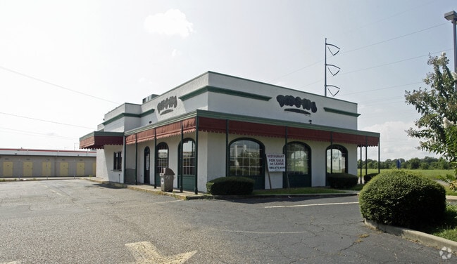


Property Detail
113 Dillard Dr
6031222
IMPT ON LEASED LAND @ 113 HOLMES DR LAND @44156
Commercialnec
Lafayette
B and X Area of moderate flood hazard, usually the area between the limits of the 100-year and 500-year floods.
Louisiana
2025
Greater Lafayette
2025
Lafayette
001412
Lafayette, LA
2,744 SF
NEARBY LISTINGS FOR SALE OR LEASE
DEMOGRAPHICS near 113 Dillard Dr
1 mile
3 mile
5 mile
2025 Total Population
7,405
66,815
131,729
2030 Population
7,677
69,516
137,636
Pop Growth 2025-2030
+ 3.67%
+ 4.04%
+ 4.48%
Average Age
39
40
39
2025 Total Households
3,300
29,178
55,946
HH Growth 2025-2030
+ 3.73%
+ 4.13%
+ 4.56%
Median Household Inc
$89,458
$75,103
$68,650
Avg Household Size
2.20
2.20
2.20
2025 Avg HH Vehicles
2.00
2.00
2.00
Median Home Value
$284,731
$287,765
$273,910
Median Year Built
1985
1986
1986
Nearby Places
Map Layers
Map Styles
 Street
 Aerial
Layers
 Traffic
 Biking
Places
Listings with unknown addresses are not visible on the map
- Restaurants
- Banks
- Shops
- Fitness
- Groceries
PUBLIC TRANSPORTATION
COMMUTER RAIL
Lafayette Amtrak Station (Sunset Limited - Amtrak)
Drive
Walk
Distance
Lafayette Amtrak Station (Sunset Limited - Amtrak)
11 min
5.7 mi
AIRPORT
Lafayette Regional/Paul Fournet Field
Drive
Walk
Distance
Lafayette Regional/Paul Fournet Field
15 min
7.5 mi
Freight Ports
Port of Iberia
Drive
Walk
Distance
Port of Iberia
35 min
23.6 mi
SALE & LEASE HISTORY
LISTING DATE
SALE/LEASE

Sep 25, 2016
For Lease
Jan 17, 2019
For Lease
Nearby Properties
Address
Land Use
TOTAL SIZE
Lot Size
Zoning
Address
Land Use
TOTAL SIZE
Lot Size
Zoning
432,844 SF
44.64 AC
Address
Land Use
TOTAL SIZE
Lot Size
Zoning
18.28 AC
Address
Land Use
TOTAL SIZE
Lot Size
Zoning
140,051 SF
26.21 AC
Address
Land Use
TOTAL SIZE
Lot Size
Zoning
13,069 SF
23.27 AC
Address
Land Use
TOTAL SIZE
Lot Size
Zoning
24.98 AC
Address
Land Use
TOTAL SIZE
Lot Size
Zoning
200,000 SF
Address
Land Use
TOTAL SIZE
Lot Size
Zoning
443,758 SF
19.73 AC
Address
Land Use
TOTAL SIZE
Lot Size
Zoning
20,775 SF
11.04 AC
Address
Land Use
TOTAL SIZE
Lot Size
Zoning
120,024 SF
Address
Land Use
TOTAL SIZE
Lot Size
Zoning
23,377 SF
14.53 AC
Address
Land Use
TOTAL SIZE
Lot Size
Zoning
4,632 SF
14.48 AC
Address
Land Use
TOTAL SIZE
Lot Size
Zoning
7,366 SF
11.92 AC
Address
Land Use
TOTAL SIZE
Lot Size
Zoning
249,875 SF
29.76 AC
Address
Land Use
TOTAL SIZE
Lot Size
Zoning
90,725 SF
17.17 AC
Address
Land Use
TOTAL SIZE
Lot Size
Zoning
7,354 SF
11.09 AC
Address
Land Use
TOTAL SIZE
Lot Size
Zoning
145,412 SF
0.01 AC
Address
Land Use
TOTAL SIZE
Lot Size
Zoning
45,651 SF
7.44 AC
Address
Land Use
TOTAL SIZE
Lot Size
Zoning
Address
Land Use
TOTAL SIZE
Lot Size
Zoning
403,466 SF
27.66 AC
Address
Land Use
TOTAL SIZE
Lot Size
Zoning
16.16 AC
Address
Land Use
TOTAL SIZE
Lot Size
Zoning
27,294 SF
12.91 AC
Address
Land Use
TOTAL SIZE
Lot Size
Zoning
191,300 SF
29.94 AC
Address
Land Use
TOTAL SIZE
Lot Size
Zoning
Address
Land Use
TOTAL SIZE
Lot Size
Zoning
11,778 SF
15.25 AC
Address
Land Use
TOTAL SIZE
Lot Size
Zoning
12,372 SF
10 AC
Address
Land Use
TOTAL SIZE
Lot Size
Zoning
10.02 AC
Address
Land Use
TOTAL SIZE
Lot Size
Zoning
30,773 SF
5.12 AC
Address
Land Use
TOTAL SIZE
Lot Size
Zoning
29.99 AC
Address
Land Use
TOTAL SIZE
Lot Size
Zoning
12,291 SF
0.02 AC
Address
Land Use
TOTAL SIZE
Lot Size
Zoning
47,960 SF
3.97 AC
The World's #1 Commercial Real Estate Marketplace
Connect with us
© 2026 CoStar Group
The information above has been obtained from sources believed reliable. While we do not doubt its accuracy we have not verified it and make no guarantee, warranty or representation about it. It is your responsibility to independently confirm its accuracy and completeness. Any projections, opinions, assumptions, or estimates used are for example only and do not represent the current or future performance of the property. The value of this transaction to you depends on tax and other factors which should be evaluated by your tax, financial, and legal advisors. You and your advisors should conduct a careful, independent investigation of the property to determine to your satisfaction the suitability of the property for your needs.