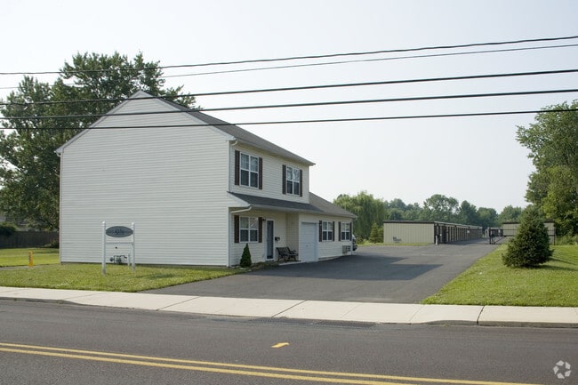
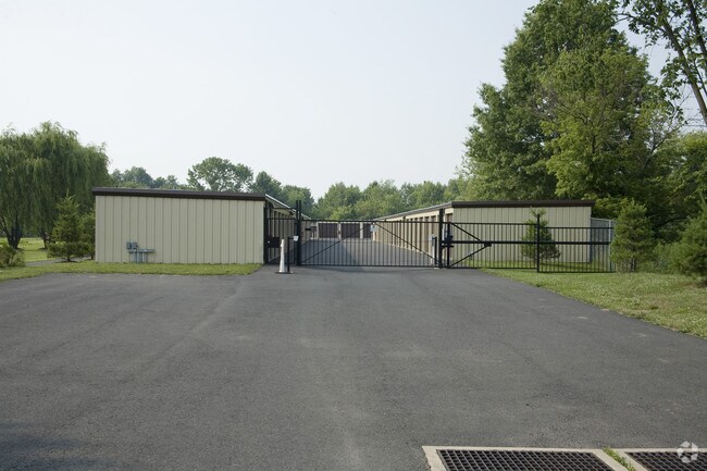
Property Record
113 E Mill St, Bristol, PA 19007

Property Detail
113 E Mill St
35-009-006
2.731AC NS MILL ST 485 W OF HELLERTOWN AVE 100 ON MILL ST
Shipyard
BUCKS
LI
Pennsylvania
AE The base floodplain where base flood elevations are provided. AE Zones are now used on new format FIRMs instead of A1-A30 Zones.
2.73 AC
2024
Upper Bucks County
2025
Philadelphia
100600
Philadelphia-Camden-Wilmington, PA-NJ-DE-MD
36,348 SF
NEARBY LISTINGS FOR SALE OR LEASE
-
-
View all Bristol listings for sale on LoopNet.com
DEMOGRAPHICS near 113 E Mill St
1 mile
3 mile
5 mile
2024 Total Population
8,282
27,144
42,761
2029 Population
8,376
27,366
43,094
Pop Growth 2024-2029
+ 1.13%
+ 0.82%
+ 0.78%
Average Age
40
42
43
2024 Total Households
3,312
10,324
16,249
HH Growth 2024-2029
+ 1.03%
+ 0.69%
+ 0.66%
Median Household Inc
$80,844
$87,301
$95,733
Avg Household Size
2.40
2.50
2.50
2024 Avg HH Vehicles
2.00
2.00
2.00
Median Home Value
$287,923
$350,762
$392,806
Median Year Built
1958
1978
1980
Nearby Places
Map Layers
Map Styles
 Street
 Aerial
Transit
 Traffic
 Biking
Places
Listings with unknown addresses are not visible on the map
- Restaurants
- Banks
- Shops
- Fitness
- Groceries
PUBLIC TRANSPORTATION
AIRPORT
Lehigh Valley International
Drive
Walk
Distance
Lehigh Valley International
36 min
20.3 mi
Trenton Mercer
Drive
Walk
Distance
Trenton Mercer
61 min
36.2 mi
Freight Ports
Port of Philadelphia
Drive
Walk
Distance
Port of Philadelphia
64 min
39.1 mi
Nearby Properties
Address
Land Use
TOTAL SIZE
Lot Size
Zoning
Address
Land Use
TOTAL SIZE
Lot Size
Zoning
276,132 SF
61.72 AC
PC
Address
Land Use
TOTAL SIZE
Lot Size
Zoning
51,884 SF
40.42 AC
EXT
Address
Land Use
TOTAL SIZE
Lot Size
Zoning
203,923 SF
34.17 AC
HC
Address
Land Use
TOTAL SIZE
Lot Size
Zoning
157,360 SF
17.34 AC
SRC
Address
Land Use
TOTAL SIZE
Lot Size
Zoning
145,197 SF
17.11 AC
PC
Address
Land Use
TOTAL SIZE
Lot Size
Zoning
127,968 SF
15.38 AC
PC
Address
Land Use
TOTAL SIZE
Lot Size
Zoning
14,450 SF
7.16 AC
R4
Address
Land Use
TOTAL SIZE
Lot Size
Zoning
86,827 SF
11.84 AC
PC
Address
Land Use
TOTAL SIZE
Lot Size
Zoning
362,576 SF
25.24 AC
PI
Address
Land Use
TOTAL SIZE
Lot Size
Zoning
1 SF
15.66 AC
PC
Address
Land Use
TOTAL SIZE
Lot Size
Zoning
215,368 SF
24.49 AC
SRM
Address
Land Use
TOTAL SIZE
Lot Size
Zoning
208,937 SF
20.07 AC
PC
Address
Land Use
TOTAL SIZE
Lot Size
Zoning
145,800 SF
11.66 AC
P1
Address
Land Use
TOTAL SIZE
Lot Size
Zoning
67,443 SF
1.97 AC
NC
Address
Land Use
TOTAL SIZE
Lot Size
Zoning
58,391 SF
9.45 AC
PC
Address
Land Use
TOTAL SIZE
Lot Size
Zoning
7.98 AC
PI
Address
Land Use
TOTAL SIZE
Lot Size
Zoning
186,547 SF
18.74 AC
PI
Address
Land Use
TOTAL SIZE
Lot Size
Zoning
1,200 SF
17.50 AC
PI
Address
Land Use
TOTAL SIZE
Lot Size
Zoning
114,400 SF
9.96 AC
P1
Address
Land Use
TOTAL SIZE
Lot Size
Zoning
71,000 SF
5.90 AC
EXT
Address
Land Use
TOTAL SIZE
Lot Size
Zoning
117,432 SF
11.92 AC
PI
Address
Land Use
TOTAL SIZE
Lot Size
Zoning
36,450 SF
3.09 AC
HC
Address
Land Use
TOTAL SIZE
Lot Size
Zoning
125,000 SF
19.58 AC
PI
Address
Land Use
TOTAL SIZE
Lot Size
Zoning
12,734 SF
4.68 AC
HC
Address
Land Use
TOTAL SIZE
Lot Size
Zoning
34,206 SF
11.49 AC
PC
Address
Land Use
TOTAL SIZE
Lot Size
Zoning
48,457 SF
2.73 AC
PC
Address
Land Use
TOTAL SIZE
Lot Size
Zoning
22,950 SF
1.97 AC
HR
Address
Land Use
TOTAL SIZE
Lot Size
Zoning
83,508 SF
7.91 AC
PI
Address
Land Use
TOTAL SIZE
Lot Size
Zoning
170,655 SF
25.75 AC
PI
Address
Land Use
TOTAL SIZE
Lot Size
Zoning
4.22 AC
R4
The World's #1 Commercial Real Estate Marketplace
Connect with us
© 2026 CoStar Group
The information above has been obtained from sources believed reliable. While we do not doubt its accuracy we have not verified it and make no guarantee, warranty or representation about it. It is your responsibility to independently confirm its accuracy and completeness. Any projections, opinions, assumptions, or estimates used are for example only and do not represent the current or future performance of the property. The value of this transaction to you depends on tax and other factors which should be evaluated by your tax, financial, and legal advisors. You and your advisors should conduct a careful, independent investigation of the property to determine to your satisfaction the suitability of the property for your needs.