Property Record
113 Evergreen Rd, Clover, SC 29710
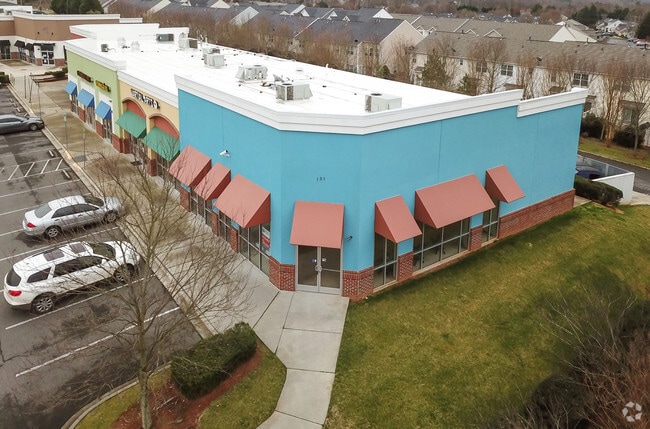

Property Detail
113 Evergreen Rd
5620000067
TRACT A(1.186AC)CHARLOTTE HWY OR HWY 49
Commercialnec
YORK
BDIII
South Carolina
B and X Area of moderate flood hazard, usually the area between the limits of the 100-year and 500-year floods.
1.19 AC
2025
York County
2025
Charlotte
061705
Charlotte-Concord-Gastonia, NC-SC
3,343 SF
NEARBY LISTINGS FOR SALE OR LEASE
DEMOGRAPHICS near 113 Evergreen Rd
1 mile
3 mile
5 mile
2025 Total Population
7,059
25,547
59,253
2030 Population
7,495
27,256
64,077
Pop Growth 2025-2030
+ 6.18%
+ 6.69%
+ 8.14%
Average Age
41
42
41
2025 Total Households
2,886
10,045
22,619
HH Growth 2025-2030
+ 6.27%
+ 6.81%
+ 8.24%
Median Household Inc
$97,517
$110,831
$114,138
Avg Household Size
2.40
2.50
2.60
2025 Avg HH Vehicles
2.00
2.00
2.00
Median Home Value
$483,048
$532,746
$517,167
Median Year Built
2005
2006
2006
Nearby Places
Map Layers
Map Styles
 Street
 Aerial
Transit
 Traffic
 Biking
Places
Listings with unknown addresses are not visible on the map
- Restaurants
- Banks
- Shops
- Fitness
- Groceries
PUBLIC TRANSPORTATION
AIRPORT
Charlotte/Douglas International
Drive
Walk
Distance
Charlotte/Douglas International
26 min
16.0 mi
Freight Ports
Port of Wilmington
Drive
Walk
Distance
Port of Wilmington
1 min
188.7 mi
SALE & LEASE HISTORY
LISTING DATE
SALE/LEASE

Nov 20, 2020
For Lease
Nearby Properties
Address
Land Use
TOTAL SIZE
Lot Size
Zoning
Address
Land Use
TOTAL SIZE
Lot Size
Zoning
415,150 SF
18.68 AC
MX-3
Address
Land Use
TOTAL SIZE
Lot Size
Zoning
972 SF
6.91 AC
B-2
Address
Land Use
TOTAL SIZE
Lot Size
Zoning
95 AC
RUD
Address
Land Use
TOTAL SIZE
Lot Size
Zoning
21,537 SF
3.32 AC
BDIII
Address
Land Use
TOTAL SIZE
Lot Size
Zoning
5,000 SF
14.33 AC
R-5
Address
Land Use
TOTAL SIZE
Lot Size
Zoning
35,174 SF
6.74 AC
B2CD
Address
Land Use
TOTAL SIZE
Lot Size
Zoning
11.62 AC
R-5
Address
Land Use
TOTAL SIZE
Lot Size
Zoning
5.45 AC
UD
Address
Land Use
TOTAL SIZE
Lot Size
Zoning
7,028 SF
11.62 AC
MX3
Address
Land Use
TOTAL SIZE
Lot Size
Zoning
38,142 SF
30.01 AC
PD
Address
Land Use
TOTAL SIZE
Lot Size
Zoning
27,372 SF
14.37 AC
RDII
Address
Land Use
TOTAL SIZE
Lot Size
Zoning
2,387 SF
4.58 AC
Address
Land Use
TOTAL SIZE
Lot Size
Zoning
13.46 AC
MX-3
Address
Land Use
TOTAL SIZE
Lot Size
Zoning
4,976 SF
3.81 AC
B2
Address
Land Use
TOTAL SIZE
Lot Size
Zoning
14.43 AC
RDI
Address
Land Use
TOTAL SIZE
Lot Size
Zoning
27,600 SF
35.50 AC
RDI
Address
Land Use
TOTAL SIZE
Lot Size
Zoning
11,851 SF
0.65 AC
Address
Land Use
TOTAL SIZE
Lot Size
Zoning
7,840 SF
10.44 AC
RDI
Address
Land Use
TOTAL SIZE
Lot Size
Zoning
4.97 AC
BDI
Address
Land Use
TOTAL SIZE
Lot Size
Zoning
44,977 SF
24.59 AC
BDIII
Address
Land Use
TOTAL SIZE
Lot Size
Zoning
8.89 AC
BDIII
Address
Land Use
TOTAL SIZE
Lot Size
Zoning
10.56 AC
Address
Land Use
TOTAL SIZE
Lot Size
Zoning
10.18 AC
Address
Land Use
TOTAL SIZE
Lot Size
Zoning
3.89 AC
BDIII
Address
Land Use
TOTAL SIZE
Lot Size
Zoning
6,103 SF
65.50 AC
RUD
Address
Land Use
TOTAL SIZE
Lot Size
Zoning
7,878 SF
47.68 AC
UD
Address
Land Use
TOTAL SIZE
Lot Size
Zoning
3,438 SF
46.81 AC
RCI
Address
Land Use
TOTAL SIZE
Lot Size
Zoning
4,910 SF
0.69 AC
RDI
Address
Land Use
TOTAL SIZE
Lot Size
Zoning
2.92 AC
BDIII
Address
Land Use
TOTAL SIZE
Lot Size
Zoning
1,730 SF
6.88 AC
RCI
The World's #1 Commercial Real Estate Marketplace
Connect with us
© 2026 CoStar Group
The information above has been obtained from sources believed reliable. While we do not doubt its accuracy we have not verified it and make no guarantee, warranty or representation about it. It is your responsibility to independently confirm its accuracy and completeness. Any projections, opinions, assumptions, or estimates used are for example only and do not represent the current or future performance of the property. The value of this transaction to you depends on tax and other factors which should be evaluated by your tax, financial, and legal advisors. You and your advisors should conduct a careful, independent investigation of the property to determine to your satisfaction the suitability of the property for your needs.