Property Record
113 Hopkins Ave, Bakersfield, CA 93308
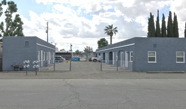

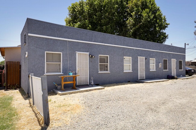
This Property Is For Sale
NEARBY LISTINGS FOR SALE OR LEASE
Property Detail
113 Hopkins Ave
Bakersfield, CA
North Bakersfield Subdivision
119-110-06-00-5
CITY NBKSD , BLOCK C , LOT PTN
Apartment
Kern
X
California
06029C1819F
ptn
2024
0.22 AC
2025
Mobile Town
000400
Bakersfield
2,430 SF
DEMOGRAPHICS near 113 Hopkins Ave
1 Mile
3 Mile
5 Mile
2024 Total Population
17,324
97,753
231,369
2029 Population
17,474
98,013
231,401
Pop Growth 2024-2029
+ 0.87%
+ 0.27%
+ 0.01%
Average Age
35
35
35
2024 Total Households
6,231
33,624
76,611
HH Growth 2024-2029
+ 0.85%
+ 0.28%
+ 0.02%
Median Household Inc
$29,028
$40,330
$44,985
Avg Household Size
2.60
2.80
2.90
2024 Avg HH Vehicles
1.00
2.00
2.00
Median Home Value
$82,740
$236,880
$252,508
Median Year Built
1973
1967
1970
Nearby Places
Map Layers
Map Styles
 Street
 Aerial
- Restaurants
- Banks
- Shops
- Fitness
- Groceries
PUBLIC TRANSPORTATION
COMMUTER RAIL
Bakersfield (San Joaquins - Amtrak)
DRIVE
WALK
Distance
Bakersfield (San Joaquins - Amtrak)
7 min
3.0 mi
AIRPORT
Meadows Field
DRIVE
WALK
Distance
Meadows Field
12 min
4.3 mi
Freight Ports
The Port of Hueneme
DRIVE
WALK
Distance
The Port of Hueneme
157 min
125.6 mi
Nearby Properties
Address
Land Use
TOTAL SIZE
Lot Size
Zoning
Address
Land Use
TOTAL SIZE
Lot Size
Zoning
402,037 SF
17.72 AC
R1
Address
Land Use
TOTAL SIZE
Lot Size
Zoning
104,693 SF
2.09 AC
HOSP
Address
Land Use
TOTAL SIZE
Lot Size
Zoning
Address
Land Use
TOTAL SIZE
Lot Size
Zoning
85,971 SF
5.31 AC
C-2
Address
Land Use
TOTAL SIZE
Lot Size
Zoning
59,242 SF
3.01 AC
C2
Address
Land Use
TOTAL SIZE
Lot Size
Zoning
112,849 SF
5.31 AC
C-2
Address
Land Use
TOTAL SIZE
Lot Size
Zoning
30,326 SF
19 AC
M3
Address
Land Use
TOTAL SIZE
Lot Size
Zoning
2,032 SF
11.08 AC
M3
Address
Land Use
TOTAL SIZE
Lot Size
Zoning
16.64 AC
Address
Land Use
TOTAL SIZE
Lot Size
Zoning
10,064 SF
13.44 AC
R3
Address
Land Use
TOTAL SIZE
Lot Size
Zoning
155,550 SF
18.51 AC
M2
Address
Land Use
TOTAL SIZE
Lot Size
Zoning
63,428 SF
5.18 AC
C-2
Address
Land Use
TOTAL SIZE
Lot Size
Zoning
41,394 SF
14.74 AC
Address
Land Use
TOTAL SIZE
Lot Size
Zoning
188,976 SF
4.92 AC
Address
Land Use
TOTAL SIZE
Lot Size
Zoning
87,389 SF
1.76 AC
M1
Address
Land Use
TOTAL SIZE
Lot Size
Zoning
Address
Land Use
TOTAL SIZE
Lot Size
Zoning
2,129 SF
11.42 AC
M-2
Address
Land Use
TOTAL SIZE
Lot Size
Zoning
151,797 SF
4.42 AC
R3
Address
Land Use
TOTAL SIZE
Lot Size
Zoning
3,383 SF
19.40 AC
M-2
Address
Land Use
TOTAL SIZE
Lot Size
Zoning
78,140 SF
2.52 AC
CC
Address
Land Use
TOTAL SIZE
Lot Size
Zoning
8 AC
M-3
Address
Land Use
TOTAL SIZE
Lot Size
Zoning
105,513 SF
1.60 AC
C-B
Address
Land Use
TOTAL SIZE
Lot Size
Zoning
200,503 SF
5.85 AC
C-2-D
Address
Land Use
TOTAL SIZE
Lot Size
Zoning
54,960 SF
15.83 AC
M-2
Address
Land Use
TOTAL SIZE
Lot Size
Zoning
0.96 AC
Address
Land Use
TOTAL SIZE
Lot Size
Zoning
37,784 SF
0.76 AC
PCD
Address
Land Use
TOTAL SIZE
Lot Size
Zoning
141,662 SF
9.39 AC
R-2
Address
Land Use
TOTAL SIZE
Lot Size
Zoning
127,504 SF
1.46 AC
CB
Address
Land Use
TOTAL SIZE
Lot Size
Zoning
43,124 SF
0.44 AC
C2
Address
Land Use
TOTAL SIZE
Lot Size
Zoning
154,142 SF
8.04 AC
C2
The World's #1 Commercial Real Estate Marketplace
Connect with us
© 2025 CoStar Group
The information above has been obtained from sources believed reliable. While we do not doubt its accuracy we have not verified it and make no guarantee, warranty or representation about it. It is your responsibility to independently confirm its accuracy and completeness. Any projections, opinions, assumptions, or estimates used are for example only and do not represent the current or future performance of the property. The value of this transaction to you depends on tax and other factors which should be evaluated by your tax, financial, and legal advisors. You and your advisors should conduct a careful, independent investigation of the property to determine to your satisfaction the suitability of the property for your needs.