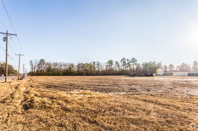
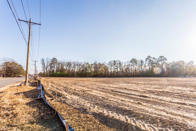
Property Record
113 Misty Dew Ln, Lexington, SC 29072
NEARBY LISTINGS FOR SALE OR LEASE
Property Detail
113 Misty Dew Ln
Pine Bluff, AR
Sec 27 Twp 5 S Rng 10 W
931-87613-000
BEG AT SE COR NW NE N 00 DEG 10 MINS W 138.78 FT TO SW'LY R/W HWY 365 TH NW'LY ALG SE R/W 797.19 FT TH LEAVING SD R/W S 01 DE
Commercialacreage
Jefferson
X
Arkansas
05069C0165D
6.22 AC
2025
Arkansas South Area
2025
Other Market Areas
000303
DEMOGRAPHICS near 113 Misty Dew Ln
1 Mile
3 Mile
5 Mile
2024 Total Population
2,951
14,276
33,892
2029 Population
2,792
13,569
32,463
Pop Growth 2024-2029
(5.39%)
(4.95%)
(4.22%)
Average Age
39
39
39
2024 Total Households
1,187
5,036
12,909
HH Growth 2024-2029
(5.31%)
(4.90%)
(4.17%)
Median Household Inc
$66,836
$60,838
$45,320
Avg Household Size
2.40
2.30
2.30
2024 Avg HH Vehicles
2.00
2.00
2.00
Median Home Value
$187,335
$137,423
$107,041
Median Year Built
1984
1984
1975
Nearby Places
Map Layers
Map Styles
 Street
 Aerial
- Restaurants
- Banks
- Shops
- Fitness
- Groceries
PUBLIC TRANSPORTATION
AIRPORT
Columbia Metro
DRIVE
WALK
Distance
Columbia Metro
33 min
14.8 mi
Freight Ports
North Charleston Terminal
DRIVE
WALK
Distance
North Charleston Terminal
134 min
112.6 mi
SALE & LEASE HISTORY
LISTING DATE
SALE/LEASE

Jan 08, 2018
For Sale
Nearby Properties
Address
Land Use
TOTAL SIZE
Lot Size
Zoning
Address
Land Use
TOTAL SIZE
Lot Size
Zoning
78,966 SF
10.34 AC
Address
Land Use
TOTAL SIZE
Lot Size
Zoning
4,198 SF
23.54 AC
Address
Land Use
TOTAL SIZE
Lot Size
Zoning
3,406 SF
19.99 AC
HDR
Address
Land Use
TOTAL SIZE
Lot Size
Zoning
204,927 SF
24.82 AC
GC
Address
Land Use
TOTAL SIZE
Lot Size
Zoning
45,171 SF
8.38 AC
ID
Address
Land Use
TOTAL SIZE
Lot Size
Zoning
64,281 SF
11.71 AC
GC
Address
Land Use
TOTAL SIZE
Lot Size
Zoning
102,553 SF
13.30 AC
GC
Address
Land Use
TOTAL SIZE
Lot Size
Zoning
9,792 SF
7.47 AC
HDR
Address
Land Use
TOTAL SIZE
Lot Size
Zoning
96,585 SF
2.62 AC
ID
Address
Land Use
TOTAL SIZE
Lot Size
Zoning
41,883 SF
21.77 AC
ID
Address
Land Use
TOTAL SIZE
Lot Size
Zoning
49,494 SF
9.98 AC
ID
Address
Land Use
TOTAL SIZE
Lot Size
Zoning
62,141 SF
7.28 AC
GC
Address
Land Use
TOTAL SIZE
Lot Size
Zoning
78,665 SF
7.58 AC
GC
Address
Land Use
TOTAL SIZE
Lot Size
Zoning
33,218 SF
4.40 AC
GC
Address
Land Use
TOTAL SIZE
Lot Size
Zoning
15,343 SF
1.30 AC
GC
Address
Land Use
TOTAL SIZE
Lot Size
Zoning
18,300 SF
3.33 AC
RD
Address
Land Use
TOTAL SIZE
Lot Size
Zoning
1,572 SF
21.04 AC
GC
Address
Land Use
TOTAL SIZE
Lot Size
Zoning
35,109 SF
11.06 AC
GC
Address
Land Use
TOTAL SIZE
Lot Size
Zoning
43,078 SF
4.50 AC
Address
Land Use
TOTAL SIZE
Lot Size
Zoning
3,810 SF
1.58 AC
ID
Address
Land Use
TOTAL SIZE
Lot Size
Zoning
59,201 SF
7.76 AC
GC
Address
Land Use
TOTAL SIZE
Lot Size
Zoning
2,100 SF
5.91 AC
LC
Address
Land Use
TOTAL SIZE
Lot Size
Zoning
79.51 AC
GC
Address
Land Use
TOTAL SIZE
Lot Size
Zoning
86,573 SF
4.92 AC
Address
Land Use
TOTAL SIZE
Lot Size
Zoning
38,716 SF
2.07 AC
GC
Address
Land Use
TOTAL SIZE
Lot Size
Zoning
1,378 SF
125.89 AC
RD
Address
Land Use
TOTAL SIZE
Lot Size
Zoning
30,555 SF
3.20 AC
GC
Address
Land Use
TOTAL SIZE
Lot Size
Zoning
15,229 SF
5.71 AC
GC
Address
Land Use
TOTAL SIZE
Lot Size
Zoning
42,216 SF
2.52 AC
GC
Address
Land Use
TOTAL SIZE
Lot Size
Zoning
15.43 AC
GC
The World's #1 Commercial Real Estate Marketplace
Connect with us
© 2026 CoStar Group
The information above has been obtained from sources believed reliable. While we do not doubt its accuracy we have not verified it and make no guarantee, warranty or representation about it. It is your responsibility to independently confirm its accuracy and completeness. Any projections, opinions, assumptions, or estimates used are for example only and do not represent the current or future performance of the property. The value of this transaction to you depends on tax and other factors which should be evaluated by your tax, financial, and legal advisors. You and your advisors should conduct a careful, independent investigation of the property to determine to your satisfaction the suitability of the property for your needs.