Property Record
113 Myrtle St, Thomasville, NC 27360
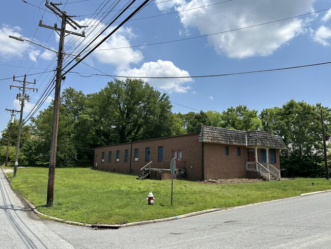

This Property Is For Sale
NEARBY LISTINGS FOR SALE OR LEASE
-
-
View all Thomasville listings for sale on LoopNet.com
Property Detail
113 Myrtle St
16-101-0-00A-0009-0-0-0
Revised Map Of The Charles C Moore Heirs
Commercialnec
P=4-126 BA L9-12 BK1613-38
X
Davidson
3710677700J
North Carolina
2025
0.31 AC
2025
North Davidson County
060800
Greensboro/Winston-Salem
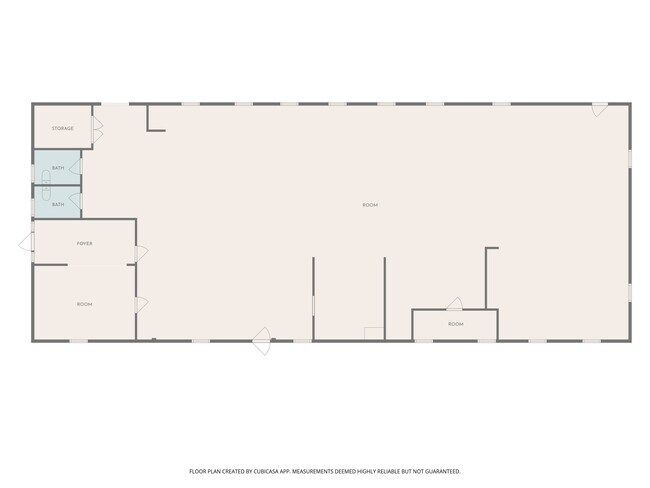
4,259 SF
Winston-Salem, NC
DEMOGRAPHICS near 113 Myrtle St
1 Mile
3 Mile
5 Mile
2024 Total Population
6,928
31,741
51,570
2029 Population
7,775
35,243
56,778
Pop Growth 2024-2029
+ 12.23%
+ 11.03%
+ 10.10%
Average Age
38
40
41
2024 Total Households
2,738
12,751
20,603
HH Growth 2024-2029
+ 12.45%
+ 11.18%
+ 10.28%
Median Household Inc
$49,456
$61,526
$62,890
Avg Household Size
2.40
2.40
2.40
2024 Avg HH Vehicles
2.00
2.00
2.00
Median Home Value
$141,744
$173,798
$201,438
Median Year Built
1970
1975
1981
Nearby Places
Map Layers
Map Styles
 Street
 Aerial
- Restaurants
- Banks
- Shops
- Fitness
- Groceries
PUBLIC TRANSPORTATION
AIRPORT
Piedmont Triad International
DRIVE
WALK
Distance
Piedmont Triad International
39 min
22.4 mi
Nearby Properties
Address
Land Use
TOTAL SIZE
Lot Size
Zoning
Address
Land Use
TOTAL SIZE
Lot Size
Zoning
154,870 SF
62.93 AC
M1
Address
Land Use
TOTAL SIZE
Lot Size
Zoning
103,482 SF
49.98 AC
OI
Address
Land Use
TOTAL SIZE
Lot Size
Zoning
66,674 SF
59.96 AC
OI
Address
Land Use
TOTAL SIZE
Lot Size
Zoning
194,644 SF
20 AC
R10
Address
Land Use
TOTAL SIZE
Lot Size
Zoning
3,638 SF
41.44 AC
OI
Address
Land Use
TOTAL SIZE
Lot Size
Zoning
235,230 SF
25.63 AC
C3
Address
Land Use
TOTAL SIZE
Lot Size
Zoning
134,369 SF
20.67 AC
R15
Address
Land Use
TOTAL SIZE
Lot Size
Zoning
13,770 SF
34.64 AC
R10
Address
Land Use
TOTAL SIZE
Lot Size
Zoning
122,865 SF
30.57 AC
R15
Address
Land Use
TOTAL SIZE
Lot Size
Zoning
9,020 SF
135.18 AC
M1CZ
Address
Land Use
TOTAL SIZE
Lot Size
Zoning
63,936 SF
19.05 AC
R10
Address
Land Use
TOTAL SIZE
Lot Size
Zoning
51,230 SF
7.52 AC
C2
Address
Land Use
TOTAL SIZE
Lot Size
Zoning
56,305 SF
5.39 AC
OI
Address
Land Use
TOTAL SIZE
Lot Size
Zoning
82,160 SF
23.62 AC
C2
Address
Land Use
TOTAL SIZE
Lot Size
Zoning
12,536 SF
300.20 AC
M1CZ
Address
Land Use
TOTAL SIZE
Lot Size
Zoning
4,224 SF
50.07 AC
M2
Address
Land Use
TOTAL SIZE
Lot Size
Zoning
57,885 SF
24.14 AC
RA3
Address
Land Use
TOTAL SIZE
Lot Size
Zoning
72,642 SF
10.53 AC
R10
Address
Land Use
TOTAL SIZE
Lot Size
Zoning
124,326 SF
13.45 AC
C3
Address
Land Use
TOTAL SIZE
Lot Size
Zoning
4,560 SF
187.84 AC
R10
Address
Land Use
TOTAL SIZE
Lot Size
Zoning
127,280 SF
29.10 AC
LI-CZ
Address
Land Use
TOTAL SIZE
Lot Size
Zoning
149,129 SF
15.65 AC
R10
Address
Land Use
TOTAL SIZE
Lot Size
Zoning
44,432 SF
22.13 AC
R10
Address
Land Use
TOTAL SIZE
Lot Size
Zoning
12,040 SF
17.95 AC
RA3
Address
Land Use
TOTAL SIZE
Lot Size
Zoning
6,960 SF
9.61 AC
R8
Address
Land Use
TOTAL SIZE
Lot Size
Zoning
63,643 SF
8.46 AC
M1
Address
Land Use
TOTAL SIZE
Lot Size
Zoning
38,896 SF
6.64 AC
C2
Address
Land Use
TOTAL SIZE
Lot Size
Zoning
162,000 SF
10.67 AC
M1
Address
Land Use
TOTAL SIZE
Lot Size
Zoning
52,466 SF
3.57 AC
C2
Address
Land Use
TOTAL SIZE
Lot Size
Zoning
39,842 SF
12.49 AC
M2
The World's #1 Commercial Real Estate Marketplace
Connect with us
© 2025 CoStar Group
The information above has been obtained from sources believed reliable. While we do not doubt its accuracy we have not verified it and make no guarantee, warranty or representation about it. It is your responsibility to independently confirm its accuracy and completeness. Any projections, opinions, assumptions, or estimates used are for example only and do not represent the current or future performance of the property. The value of this transaction to you depends on tax and other factors which should be evaluated by your tax, financial, and legal advisors. You and your advisors should conduct a careful, independent investigation of the property to determine to your satisfaction the suitability of the property for your needs.