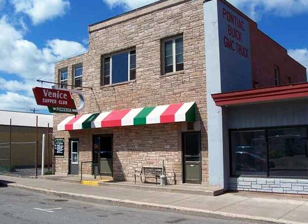
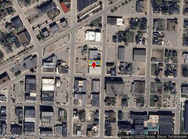
Property Record
113 N 2Nd St, Ishpeming, MI 49849

NEARBY LISTINGS FOR SALE OR LEASE
Property Detail
113 N 2Nd St
Marquette, MI
Original City Of Ishpeming
52-51-050-141-00
ORIGINAL PLAT CITY OF ISHPEMING LOT 141.
Commercialnec
Marquette
X
Michigan
26103C0631E
141
2025
0.08 AC
2025
Upper Peninsula
001900
Other Market Areas
4,768 SF
DEMOGRAPHICS near 113 N 2Nd St
1 Mile
3 Mile
5 Mile
2024 Total Population
4,896
11,549
15,448
2029 Population
4,974
11,742
15,709
Pop Growth 2024-2029
+ 1.59%
+ 1.67%
+ 1.69%
Average Age
40
41
41
2024 Total Households
2,192
4,972
6,559
HH Growth 2024-2029
+ 1.78%
+ 1.83%
+ 1.83%
Median Household Inc
$45,082
$52,046
$54,652
Avg Household Size
2.10
2.20
2.30
2024 Avg HH Vehicles
2.00
2.00
2.00
Median Home Value
$92,790
$126,650
$135,810
Median Year Built
1947
1949
1952
Nearby Places
Map Layers
Map Styles
 Street
 Aerial
- Restaurants
- Banks
- Shops
- Fitness
- Groceries
PUBLIC TRANSPORTATION
AIRPORT
Marquette/Sawyer Regional
DRIVE
WALK
Distance
Marquette/Sawyer Regional
38 min
21.9 mi
Freight Ports
Port Milwaukee
DRIVE
WALK
Distance
Port Milwaukee
343 min
282.0 mi
SALE & LEASE HISTORY
LISTING DATE
SALE/LEASE

Oct 26, 2020
For Sale
Nearby Properties
Address
Land Use
TOTAL SIZE
Lot Size
Zoning
Address
Land Use
TOTAL SIZE
Lot Size
Zoning
Address
Land Use
TOTAL SIZE
Lot Size
Zoning
148,007 SF
40 AC
DD
Address
Land Use
TOTAL SIZE
Lot Size
Zoning
31,930 SF
6.44 AC
R-2
Address
Land Use
TOTAL SIZE
Lot Size
Zoning
32,858 SF
6.19 AC
B-2
Address
Land Use
TOTAL SIZE
Lot Size
Zoning
40,081 SF
9.17 AC
Address
Land Use
TOTAL SIZE
Lot Size
Zoning
6,724 SF
1.29 AC
GC
Address
Land Use
TOTAL SIZE
Lot Size
Zoning
39,832 SF
15 AC
GC
Address
Land Use
TOTAL SIZE
Lot Size
Zoning
66,472 SF
7.16 AC
MR
Address
Land Use
TOTAL SIZE
Lot Size
Zoning
28,683 SF
2.06 AC
GC
Address
Land Use
TOTAL SIZE
Lot Size
Zoning
50,200 SF
10.60 AC
I
Address
Land Use
TOTAL SIZE
Lot Size
Zoning
41,165 SF
5.50 AC
GC
Address
Land Use
TOTAL SIZE
Lot Size
Zoning
25,648 SF
3.62 AC
Address
Land Use
TOTAL SIZE
Lot Size
Zoning
77,680 SF
17.82 AC
I
Address
Land Use
TOTAL SIZE
Lot Size
Zoning
21,099 SF
4.60 AC
I
Address
Land Use
TOTAL SIZE
Lot Size
Zoning
31,075 SF
1 AC
GC
Address
Land Use
TOTAL SIZE
Lot Size
Zoning
18,718 SF
1.70 AC
GC
Address
Land Use
TOTAL SIZE
Lot Size
Zoning
24,124 SF
1.89 AC
B-2
Address
Land Use
TOTAL SIZE
Lot Size
Zoning
28,280 SF
3.26 AC
MR
Address
Land Use
TOTAL SIZE
Lot Size
Zoning
12,755 SF
4.32 AC
GB GENERAL
Address
Land Use
TOTAL SIZE
Lot Size
Zoning
960 SF
20.40 AC
Address
Land Use
TOTAL SIZE
Lot Size
Zoning
14,680 SF
1.19 AC
Address
Land Use
TOTAL SIZE
Lot Size
Zoning
6,676 SF
0.37 AC
Address
Land Use
TOTAL SIZE
Lot Size
Zoning
3,900 SF
1.37 AC
B-2
Address
Land Use
TOTAL SIZE
Lot Size
Zoning
41,308 SF
6.90 AC
I
Address
Land Use
TOTAL SIZE
Lot Size
Zoning
9,970 SF
2.12 AC
Address
Land Use
TOTAL SIZE
Lot Size
Zoning
2,947 SF
1.34 AC
GC
Address
Land Use
TOTAL SIZE
Lot Size
Zoning
22,500 SF
3.18 AC
GC
Address
Land Use
TOTAL SIZE
Lot Size
Zoning
5,019 SF
1.50 AC
GC
Address
Land Use
TOTAL SIZE
Lot Size
Zoning
9,272 SF
2.27 AC
The World's #1 Commercial Real Estate Marketplace
Connect with us
© 2026 CoStar Group
The information above has been obtained from sources believed reliable. While we do not doubt its accuracy we have not verified it and make no guarantee, warranty or representation about it. It is your responsibility to independently confirm its accuracy and completeness. Any projections, opinions, assumptions, or estimates used are for example only and do not represent the current or future performance of the property. The value of this transaction to you depends on tax and other factors which should be evaluated by your tax, financial, and legal advisors. You and your advisors should conduct a careful, independent investigation of the property to determine to your satisfaction the suitability of the property for your needs.