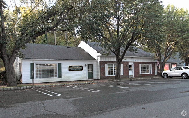
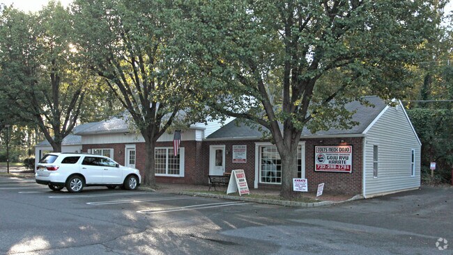
Property Record
113 Route 34, Farmingdale, NJ 07727
NEARBY LISTINGS FOR SALE OR LEASE
Property Detail
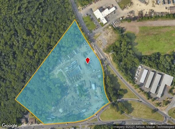
113 Route 34
21-00183-0000-00116-02
Beddle Co Inc
Officebuilding
Monmouth
X
New Jersey
34025C0310F
115.1
2024
12.95 AC
2025
Eastern Monmouth
811600
Northern New Jersey
1,458 SF
New York-Jersey City-White Plains, NY-NJ
DEMOGRAPHICS near 113 Route 34
1 Mile
3 Mile
5 Mile
2024 Total Population
1,010
7,234
45,267
2029 Population
1,006
7,171
44,819
Pop Growth 2024-2029
(0.40%)
(0.87%)
(0.99%)
Average Age
41
42
42
2024 Total Households
325
2,369
15,666
HH Growth 2024-2029
(0.62%)
(1.14%)
(1.19%)
Median Household Inc
$156,522
$184,813
$160,521
Avg Household Size
3.10
3.00
2.80
2024 Avg HH Vehicles
2.00
2.00
2.00
Median Home Value
$841,715
$820,149
$673,733
Median Year Built
1982
1981
1986
Nearby Places
Map Layers
Map Styles
 Street
 Aerial
- Restaurants
- Banks
- Shops
- Fitness
- Groceries
PUBLIC TRANSPORTATION
COMMUTER RAIL
Asbury Park (North Jersey Coast Line - NJ Transit Commuter Rail (NJ Transit))
DRIVE
WALK
Distance
Asbury Park (North Jersey Coast Line - NJ Transit Commuter Rail (NJ Transit))
12 min
8.3 mi
Bradley Beach (North Jersey Coast Line - NJ Transit Commuter Rail (NJ Transit))
DRIVE
WALK
Distance
Bradley Beach (North Jersey Coast Line - NJ Transit Commuter Rail (NJ Transit))
12 min
8.4 mi
Freight Ports
New York Container Terminal
DRIVE
WALK
Distance
New York Container Terminal
52 min
39.9 mi
Nearby Properties
Address
Land Use
TOTAL SIZE
Lot Size
Zoning
Address
Land Use
TOTAL SIZE
Lot Size
Zoning
434,405 SF
52.92 AC
RT66
Address
Land Use
TOTAL SIZE
Lot Size
Zoning
3.65 AC
AG
Address
Land Use
TOTAL SIZE
Lot Size
Zoning
3,255.78 AC
ARE6
Address
Land Use
TOTAL SIZE
Lot Size
Zoning
134,075 SF
339.89 AC
OSGS
Address
Land Use
TOTAL SIZE
Lot Size
Zoning
37.47 AC
AH
Address
Land Use
TOTAL SIZE
Lot Size
Zoning
152,121 SF
22.16 AC
OR10
Address
Land Use
TOTAL SIZE
Lot Size
Zoning
192,708 SF
33.36 AC
OR10
Address
Land Use
TOTAL SIZE
Lot Size
Zoning
3,040 SF
194.08 AC
OSGS
Address
Land Use
TOTAL SIZE
Lot Size
Zoning
13 AC
R-40
Address
Land Use
TOTAL SIZE
Lot Size
Zoning
25,536 SF
21.95 AC
OR10
Address
Land Use
TOTAL SIZE
Lot Size
Zoning
912 SF
201.36 AC
RRC
Address
Land Use
TOTAL SIZE
Lot Size
Zoning
427.37 AC
POS
Address
Land Use
TOTAL SIZE
Lot Size
Zoning
332,213 SF
26.55 AC
OR10
Address
Land Use
TOTAL SIZE
Lot Size
Zoning
103.42 AC
OSGS
Address
Land Use
TOTAL SIZE
Lot Size
Zoning
379 AC
SF80
Address
Land Use
TOTAL SIZE
Lot Size
Zoning
647.36 AC
HD03
Address
Land Use
TOTAL SIZE
Lot Size
Zoning
99.06 AC
MFG
Address
Land Use
TOTAL SIZE
Lot Size
Zoning
71,660 SF
4.45 AC
C-1
Address
Land Use
TOTAL SIZE
Lot Size
Zoning
7,350 SF
161.08 AC
MFG
Address
Land Use
TOTAL SIZE
Lot Size
Zoning
12.74 AC
CCRC
Address
Land Use
TOTAL SIZE
Lot Size
Zoning
3.61 AC
AR3P
Address
Land Use
TOTAL SIZE
Lot Size
Zoning
3,474 SF
4.12 AC
OR10
Address
Land Use
TOTAL SIZE
Lot Size
Zoning
79,746 SF
9.06 AC
OR10
Address
Land Use
TOTAL SIZE
Lot Size
Zoning
1,014 SF
49.80 AC
R-1
Address
Land Use
TOTAL SIZE
Lot Size
Zoning
11.67 AC
IO20
Address
Land Use
TOTAL SIZE
Lot Size
Zoning
55,984 SF
16.11 AC
LI
Address
Land Use
TOTAL SIZE
Lot Size
Zoning
6.04 AC
OP-2
Address
Land Use
TOTAL SIZE
Lot Size
Zoning
10.11 AC
SED
Address
Land Use
TOTAL SIZE
Lot Size
Zoning
7,064 SF
10.62 AC
OR10
Address
Land Use
TOTAL SIZE
Lot Size
Zoning
91,180 SF
27.20 AC
SED
The World's #1 Commercial Real Estate Marketplace
Connect with us
© 2025 CoStar Group
The information above has been obtained from sources believed reliable. While we do not doubt its accuracy we have not verified it and make no guarantee, warranty or representation about it. It is your responsibility to independently confirm its accuracy and completeness. Any projections, opinions, assumptions, or estimates used are for example only and do not represent the current or future performance of the property. The value of this transaction to you depends on tax and other factors which should be evaluated by your tax, financial, and legal advisors. You and your advisors should conduct a careful, independent investigation of the property to determine to your satisfaction the suitability of the property for your needs.