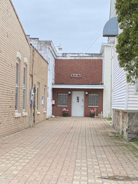
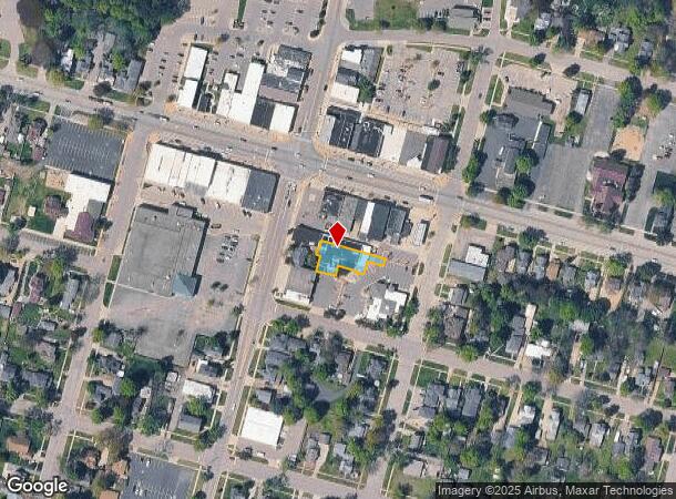
Property Record
113 S Farmer St, Otsego, MI 49078
NEARBY LISTINGS FOR SALE OR LEASE
Property Detail
113 S Farmer St
54-100-047-00
COM ON THE E SIDE OF FARMER ST 112 FT S OF THE S SIDE OF ALLEGAN ST TH E'LY PPL WITH ALLEGAN ST 184 1/2 FT TH S'LY AT RT ANG 50 1/2 FT TH W'LY PPL WITH ALLEGAN ST 101 1/2 FT TH N'LY AT RT ANG 14 FT TH W'LY AT RT ANG 13 FT TH N'LY AT RT ANG 16 FT TH E
Charitableorganization
Allegan
X
Michigan
26005C0604G
47-48
2024
0.20 AC
2025
Outlying Allegan County
031900
West Michigan
7,455 SF
Holland, MI
DEMOGRAPHICS near 113 S Farmer St
1 Mile
3 Mile
5 Mile
2024 Total Population
4,024
12,613
18,433
2029 Population
4,036
12,713
18,572
Pop Growth 2024-2029
+ 0.30%
+ 0.79%
+ 0.75%
Average Age
40
40
41
2024 Total Households
1,592
4,945
7,201
HH Growth 2024-2029
+ 0.13%
+ 0.67%
+ 0.62%
Median Household Inc
$69,538
$71,819
$73,420
Avg Household Size
2.50
2.50
2.50
2024 Avg HH Vehicles
2.00
2.00
2.00
Median Home Value
$143,988
$159,340
$171,380
Median Year Built
1955
1972
1973
Nearby Places
Map Layers
Map Styles
 Street
 Aerial
- Restaurants
- Banks
- Shops
- Fitness
- Groceries
PUBLIC TRANSPORTATION
AIRPORT
Kalamazoo/Battle Creek International
DRIVE
WALK
Distance
Kalamazoo/Battle Creek International
32 min
23.2 mi
Freight Ports
Port Milwaukee
DRIVE
WALK
Distance
Port Milwaukee
283 min
242.6 mi
SALE & LEASE HISTORY
LISTING DATE
SALE/LEASE

Sep 12, 2022
For Sale
Nearby Properties
Address
Land Use
TOTAL SIZE
Lot Size
Zoning
Address
Land Use
TOTAL SIZE
Lot Size
Zoning
164,105 SF
18.53 AC
Address
Land Use
TOTAL SIZE
Lot Size
Zoning
223,854 SF
24.74 AC
Address
Land Use
TOTAL SIZE
Lot Size
Zoning
71,337 SF
7.04 AC
Address
Land Use
TOTAL SIZE
Lot Size
Zoning
214,356 SF
23.34 AC
Address
Land Use
TOTAL SIZE
Lot Size
Zoning
48,898 SF
5.30 AC
Address
Land Use
TOTAL SIZE
Lot Size
Zoning
296,432 SF
27 AC
Address
Land Use
TOTAL SIZE
Lot Size
Zoning
72,500 SF
Address
Land Use
TOTAL SIZE
Lot Size
Zoning
40,864 SF
Address
Land Use
TOTAL SIZE
Lot Size
Zoning
18,388 SF
8.85 AC
R-2
Address
Land Use
TOTAL SIZE
Lot Size
Zoning
66,575 SF
6.31 AC
Address
Land Use
TOTAL SIZE
Lot Size
Zoning
95,484 SF
8.83 AC
Address
Land Use
TOTAL SIZE
Lot Size
Zoning
345,769 SF
33 AC
Address
Land Use
TOTAL SIZE
Lot Size
Zoning
107,850 SF
15 AC
Address
Land Use
TOTAL SIZE
Lot Size
Zoning
21,047 SF
4.74 AC
Address
Land Use
TOTAL SIZE
Lot Size
Zoning
16,886 SF
1.86 AC
Address
Land Use
TOTAL SIZE
Lot Size
Zoning
39,656 SF
5.56 AC
Address
Land Use
TOTAL SIZE
Lot Size
Zoning
30,220 SF
7.28 AC
Address
Land Use
TOTAL SIZE
Lot Size
Zoning
34,801 SF
0.92 AC
Address
Land Use
TOTAL SIZE
Lot Size
Zoning
41,362 SF
0.92 AC
Address
Land Use
TOTAL SIZE
Lot Size
Zoning
28,160 SF
4.38 AC
Address
Land Use
TOTAL SIZE
Lot Size
Zoning
30,960 SF
5.04 AC
Address
Land Use
TOTAL SIZE
Lot Size
Zoning
1,119 SF
26.41 AC
RMH
Address
Land Use
TOTAL SIZE
Lot Size
Zoning
14,560 SF
2.12 AC
Address
Land Use
TOTAL SIZE
Lot Size
Zoning
30,320 SF
1.94 AC
Address
Land Use
TOTAL SIZE
Lot Size
Zoning
2,247 SF
185.52 AC
Address
Land Use
TOTAL SIZE
Lot Size
Zoning
17,018 SF
3.51 AC
Address
Land Use
TOTAL SIZE
Lot Size
Zoning
960 SF
14.39 AC
Address
Land Use
TOTAL SIZE
Lot Size
Zoning
3,278 SF
80.44 AC
AG
Address
Land Use
TOTAL SIZE
Lot Size
Zoning
18,335 SF
0.40 AC
Address
Land Use
TOTAL SIZE
Lot Size
Zoning
69,609 SF
2.08 AC
The World's #1 Commercial Real Estate Marketplace
Connect with us
© 2025 CoStar Group
The information above has been obtained from sources believed reliable. While we do not doubt its accuracy we have not verified it and make no guarantee, warranty or representation about it. It is your responsibility to independently confirm its accuracy and completeness. Any projections, opinions, assumptions, or estimates used are for example only and do not represent the current or future performance of the property. The value of this transaction to you depends on tax and other factors which should be evaluated by your tax, financial, and legal advisors. You and your advisors should conduct a careful, independent investigation of the property to determine to your satisfaction the suitability of the property for your needs.