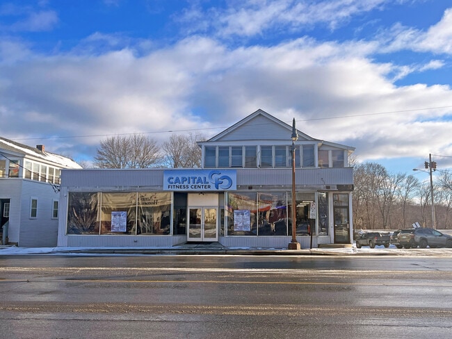
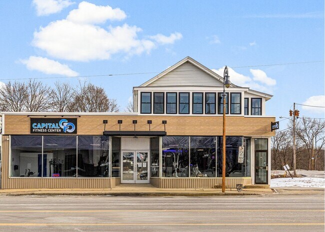
Property Record
229 Brickett Hill Rd, Pembroke, NH 03275
NEARBY LISTINGS FOR SALE OR LEASE
-
-
View all Pembroke listings for lease on LoopNet.com
Property Detail
229 Brickett Hill Rd
PMBR-000563-000000-000048
Merrimack
Duplex
New Hampshire
X
9
33013C0561E
0.25 AC
2024
Concord/New Hampshire North Area
2024
Other Market Areas
032200
Concord, NH
3,743 SF
DEMOGRAPHICS near 229 Brickett Hill Rd
1 Mile
3 Mile
5 Mile
2024 Total Population
8,776
28,885
45,223
2029 Population
9,231
30,274
47,553
Pop Growth 2024-2029
+ 5.18%
+ 4.81%
+ 5.15%
Average Age
42
43
43
2024 Total Households
4,176
12,615
18,571
HH Growth 2024-2029
+ 5.12%
+ 4.91%
+ 5.22%
Median Household Inc
$63,483
$68,891
$80,742
Avg Household Size
2.00
2.10
2.30
2024 Avg HH Vehicles
2.00
2.00
2.00
Median Home Value
$278,854
$291,340
$317,950
Median Year Built
1947
1964
1972
Nearby Places
Map Layers
Map Styles
 Street
 Aerial
- Restaurants
- Banks
- Shops
- Fitness
- Groceries
PUBLIC TRANSPORTATION
AIRPORT
Manchester Boston Regional
DRIVE
WALK
Distance
Manchester Boston Regional
43 min
26.1 mi
Freight Ports
Port of Boston
DRIVE
WALK
Distance
Port of Boston
108 min
66.4 mi
SALE & LEASE HISTORY
LISTING DATE
SALE/LEASE

Jan 27, 2025
For Lease
Feb 23, 2024
For Lease
Nearby Properties
Address
Land Use
TOTAL SIZE
Lot Size
Zoning
Address
Land Use
TOTAL SIZE
Lot Size
Zoning
266,056 SF
22.11 AC
I2
Address
Land Use
TOTAL SIZE
Lot Size
Zoning
283,455 SF
80 AC
LO-A
Address
Land Use
TOTAL SIZE
Lot Size
Zoning
6,000 SF
66.58 AC
I2
Address
Land Use
TOTAL SIZE
Lot Size
Zoning
156 AC
IS
Address
Land Use
TOTAL SIZE
Lot Size
Zoning
65.25 AC
IN
Address
Land Use
TOTAL SIZE
Lot Size
Zoning
11,576 SF
191 AC
C-1A
Address
Land Use
TOTAL SIZE
Lot Size
Zoning
147,477 SF
41.81 AC
R-1A
Address
Land Use
TOTAL SIZE
Lot Size
Zoning
110 AC
IN
Address
Land Use
TOTAL SIZE
Lot Size
Zoning
5 AC
C
Address
Land Use
TOTAL SIZE
Lot Size
Zoning
64,843 SF
6.60 AC
C
Address
Land Use
TOTAL SIZE
Lot Size
Zoning
76,705 SF
11.11 AC
CH
Address
Land Use
TOTAL SIZE
Lot Size
Zoning
35,043 SF
10.40 AC
C
Address
Land Use
TOTAL SIZE
Lot Size
Zoning
5,052 SF
111.66 AC
RH
Address
Land Use
TOTAL SIZE
Lot Size
Zoning
7,475 SF
49.90 AC
C-1D
Address
Land Use
TOTAL SIZE
Lot Size
Zoning
15.55 AC
IN
Address
Land Use
TOTAL SIZE
Lot Size
Zoning
14,210 SF
20.51 AC
C-1A
Address
Land Use
TOTAL SIZE
Lot Size
Zoning
4.93 AC
RS
Address
Land Use
TOTAL SIZE
Lot Size
Zoning
68,320 SF
2.04 AC
OCP
Address
Land Use
TOTAL SIZE
Lot Size
Zoning
233,893 SF
9.34 AC
I-1
Address
Land Use
TOTAL SIZE
Lot Size
Zoning
6.29 AC
CH
Address
Land Use
TOTAL SIZE
Lot Size
Zoning
13.01 AC
IN
Address
Land Use
TOTAL SIZE
Lot Size
Zoning
11,880 SF
44.59 AC
I-1
Address
Land Use
TOTAL SIZE
Lot Size
Zoning
2,912 SF
116.87 AC
INST/R
Address
Land Use
TOTAL SIZE
Lot Size
Zoning
24,207 SF
9.25 AC
C
Address
Land Use
TOTAL SIZE
Lot Size
Zoning
6.01 AC
CH
Address
Land Use
TOTAL SIZE
Lot Size
Zoning
10,200 SF
26.88 AC
I2
Address
Land Use
TOTAL SIZE
Lot Size
Zoning
86,346 SF
3.60 AC
IN
Address
Land Use
TOTAL SIZE
Lot Size
Zoning
12.09 AC
IN
Address
Land Use
TOTAL SIZE
Lot Size
Zoning
70,416 SF
8.50 AC
I2
Address
Land Use
TOTAL SIZE
Lot Size
Zoning
39,068 SF
2.07 AC
CG
The World's #1 Commercial Real Estate Marketplace
Connect with us
© 2025 CoStar Group
The information above has been obtained from sources believed reliable. While we do not doubt its accuracy we have not verified it and make no guarantee, warranty or representation about it. It is your responsibility to independently confirm its accuracy and completeness. Any projections, opinions, assumptions, or estimates used are for example only and do not represent the current or future performance of the property. The value of this transaction to you depends on tax and other factors which should be evaluated by your tax, financial, and legal advisors. You and your advisors should conduct a careful, independent investigation of the property to determine to your satisfaction the suitability of the property for your needs.