Property Record
113 S State Highway M553, Gwinn, MI 49841
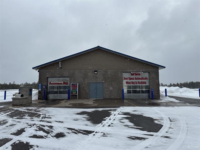
This Property Is For Sale
NEARBY LISTINGS FOR SALE OR LEASE
-
-
View all Gwinn listings for sale on LoopNet.com
Property Detail
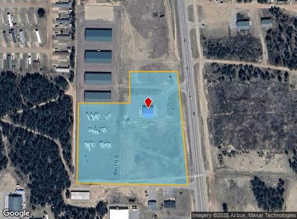
113 S State Highway M553
52-05-122-013-10
FO 727-0 SEC 22 T45N R25W 7.07 AC THAT PART OF THE N 551.05' OF SW 1/4 OF SE 1/4 LYING W OF CO RD 553 & N OF M-35 EXC THE S 3
Commercialnec
Marquette
X
Michigan
26103C0700E
7.07 AC
2025
Upper Peninsula
2025
Other Market Areas
001300
Marquette, MI
3,136 SF
DEMOGRAPHICS near 113 S State Highway M553
1 Mile
3 Mile
5 Mile
2024 Total Population
1,140
3,040
6,776
2029 Population
1,155
3,066
6,926
Pop Growth 2024-2029
+ 1.32%
+ 0.86%
+ 2.21%
Average Age
44
44
40
2024 Total Households
518
1,378
2,853
HH Growth 2024-2029
+ 1.35%
+ 0.80%
+ 2.17%
Median Household Inc
$54,333
$57,902
$50,366
Avg Household Size
2.20
2.20
2.40
2024 Avg HH Vehicles
2.00
2.00
2.00
Median Home Value
$127,307
$150,304
$138,632
Median Year Built
1976
1975
1970
Nearby Places
Map Layers
Map Styles
 Street
 Aerial
- Restaurants
- Banks
- Shops
- Fitness
- Groceries
PUBLIC TRANSPORTATION
AIRPORT
Marquette/Sawyer Regional
DRIVE
WALK
Distance
Marquette/Sawyer Regional
12 min
6.2 mi
Nearby Properties
Address
Land Use
TOTAL SIZE
Lot Size
Zoning
Address
Land Use
TOTAL SIZE
Lot Size
Zoning
25,584 SF
4.03 AC
R-3
Address
Land Use
TOTAL SIZE
Lot Size
Zoning
5,222 SF
1.58 AC
MU
Address
Land Use
TOTAL SIZE
Lot Size
Zoning
7,272 SF
0.64 AC
R-3
Address
Land Use
TOTAL SIZE
Lot Size
Zoning
34,560 SF
5.43 AC
MU
Address
Land Use
TOTAL SIZE
Lot Size
Zoning
21,184 SF
2.58 AC
R-3
Address
Land Use
TOTAL SIZE
Lot Size
Zoning
1,466 SF
9 AC
LR
Address
Land Use
TOTAL SIZE
Lot Size
Zoning
7,000 SF
10.88 AC
MU
Address
Land Use
TOTAL SIZE
Lot Size
Zoning
14,036 SF
12.43 AC
MU
Address
Land Use
TOTAL SIZE
Lot Size
Zoning
9,324 SF
1.14 AC
MU
Address
Land Use
TOTAL SIZE
Lot Size
Zoning
9,100 SF
0.93 AC
MU
Address
Land Use
TOTAL SIZE
Lot Size
Zoning
3,192 SF
0.62 AC
MU
Address
Land Use
TOTAL SIZE
Lot Size
Zoning
1,543 SF
5.01 AC
LR
Address
Land Use
TOTAL SIZE
Lot Size
Zoning
2,880 SF
1.53 AC
MU
Address
Land Use
TOTAL SIZE
Lot Size
Zoning
7,440 SF
0.32 AC
MU
Address
Land Use
TOTAL SIZE
Lot Size
Zoning
11,636 SF
2.60 AC
R-2
Address
Land Use
TOTAL SIZE
Lot Size
Zoning
4,944 SF
0.49 AC
MU
Address
Land Use
TOTAL SIZE
Lot Size
Zoning
1,232 SF
0.69 AC
LR
Address
Land Use
TOTAL SIZE
Lot Size
Zoning
14,264 SF
3.14 AC
Address
Land Use
TOTAL SIZE
Lot Size
Zoning
9,180 SF
1.38 AC
MU
Address
Land Use
TOTAL SIZE
Lot Size
Zoning
11,280 SF
1.50 AC
MU
Address
Land Use
TOTAL SIZE
Lot Size
Zoning
21,393 SF
1.93 AC
MU
Address
Land Use
TOTAL SIZE
Lot Size
Zoning
2,484 SF
0.77 AC
MU
Address
Land Use
TOTAL SIZE
Lot Size
Zoning
7,662 SF
0.50 AC
MU
Address
Land Use
TOTAL SIZE
Lot Size
Zoning
17,868 SF
3.52 AC
C-2
Address
Land Use
TOTAL SIZE
Lot Size
Zoning
7,263 SF
2.87 AC
C-2
Address
Land Use
TOTAL SIZE
Lot Size
Zoning
19.26 AC
MH-2
Address
Land Use
TOTAL SIZE
Lot Size
Zoning
16,128 SF
0.97 AC
R-3
Address
Land Use
TOTAL SIZE
Lot Size
Zoning
1,065 SF
0.34 AC
LR
Address
Land Use
TOTAL SIZE
Lot Size
Zoning
3,146 SF
0.88 AC
MU
The World's #1 Commercial Real Estate Marketplace
Connect with us
© 2026 CoStar Group
The information above has been obtained from sources believed reliable. While we do not doubt its accuracy we have not verified it and make no guarantee, warranty or representation about it. It is your responsibility to independently confirm its accuracy and completeness. Any projections, opinions, assumptions, or estimates used are for example only and do not represent the current or future performance of the property. The value of this transaction to you depends on tax and other factors which should be evaluated by your tax, financial, and legal advisors. You and your advisors should conduct a careful, independent investigation of the property to determine to your satisfaction the suitability of the property for your needs.