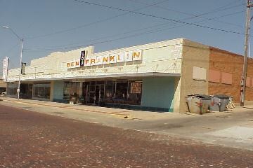
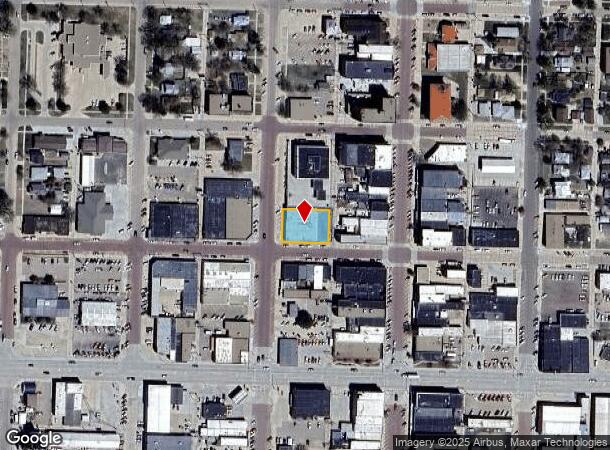
Property Record
113 W C St, Mc Cook, NE 69001
NEARBY LISTINGS FOR SALE OR LEASE
-
-
View all Mc Cook listings for sale on LoopNet.com
Property Detail
113 W C St
000717800
Fourth Parkview Subdivision
Storebuilding
ORIGINAL MCCOOK BLK 16, LOTS 13,14,15 & 16
X
Red Willow
31145C0185C
Nebraska
2024
13-16
2025
0.32 AC
963300
Nebraska Area
13,814 SF
Other Market Areas
DEMOGRAPHICS near 113 W C St
1 Mile
3 Mile
5 Mile
2024 Total Population
5,627
8,172
8,637
2029 Population
5,559
8,068
8,525
Pop Growth 2024-2029
(1.21%)
(1.27%)
(1.30%)
Average Age
40
41
41
2024 Total Households
2,411
3,453
3,645
HH Growth 2024-2029
(1.20%)
(1.25%)
(1.26%)
Median Household Inc
$51,894
$53,224
$53,204
Avg Household Size
2.20
2.20
2.20
2024 Avg HH Vehicles
2.00
2.00
2.00
Median Home Value
$136,264
$145,373
$147,302
Median Year Built
1954
1957
1957
Nearby Places
Map Layers
Map Styles
 Street
 Aerial
- Restaurants
- Banks
- Shops
- Fitness
- Groceries
PUBLIC TRANSPORTATION
COMMUTER RAIL
DRIVE
WALK
Distance
1 min
4 min
0.2 mi
Nearby Properties
Address
Land Use
TOTAL SIZE
Lot Size
Zoning
Address
Land Use
TOTAL SIZE
Lot Size
Zoning
44,268 SF
10.15 AC
Address
Land Use
TOTAL SIZE
Lot Size
Zoning
115,974 SF
32.51 AC
Address
Land Use
TOTAL SIZE
Lot Size
Zoning
140,863 SF
20 AC
Address
Land Use
TOTAL SIZE
Lot Size
Zoning
51,999 SF
15.98 AC
Address
Land Use
TOTAL SIZE
Lot Size
Zoning
61,250 SF
13.35 AC
Address
Land Use
TOTAL SIZE
Lot Size
Zoning
31,581 SF
1.64 AC
Address
Land Use
TOTAL SIZE
Lot Size
Zoning
14.63 AC
Address
Land Use
TOTAL SIZE
Lot Size
Zoning
28,747 SF
2.18 AC
Address
Land Use
TOTAL SIZE
Lot Size
Zoning
3,300 SF
3.24 AC
Address
Land Use
TOTAL SIZE
Lot Size
Zoning
8,934 SF
3.68 AC
Address
Land Use
TOTAL SIZE
Lot Size
Zoning
35,400 SF
9 AC
Address
Land Use
TOTAL SIZE
Lot Size
Zoning
7,200 SF
12.63 AC
Address
Land Use
TOTAL SIZE
Lot Size
Zoning
11,760 SF
0.24 AC
Address
Land Use
TOTAL SIZE
Lot Size
Zoning
4,798 SF
0.39 AC
Address
Land Use
TOTAL SIZE
Lot Size
Zoning
27,480 SF
6.51 AC
Address
Land Use
TOTAL SIZE
Lot Size
Zoning
51,291 SF
5.94 AC
Address
Land Use
TOTAL SIZE
Lot Size
Zoning
4,080 SF
14.70 AC
Address
Land Use
TOTAL SIZE
Lot Size
Zoning
15,360 SF
3.72 AC
Address
Land Use
TOTAL SIZE
Lot Size
Zoning
21,472 SF
2.54 AC
Address
Land Use
TOTAL SIZE
Lot Size
Zoning
23,220 SF
2.31 AC
Address
Land Use
TOTAL SIZE
Lot Size
Zoning
8,790 SF
0.32 AC
Address
Land Use
TOTAL SIZE
Lot Size
Zoning
5,387 SF
0.44 AC
Address
Land Use
TOTAL SIZE
Lot Size
Zoning
32,080 SF
2.46 AC
Address
Land Use
TOTAL SIZE
Lot Size
Zoning
6,552 SF
0.96 AC
Address
Land Use
TOTAL SIZE
Lot Size
Zoning
4,500 SF
1.96 AC
Address
Land Use
TOTAL SIZE
Lot Size
Zoning
20,960 SF
1.32 AC
Address
Land Use
TOTAL SIZE
Lot Size
Zoning
32,076 SF
3.08 AC
Address
Land Use
TOTAL SIZE
Lot Size
Zoning
25,483 SF
1.62 AC
Address
Land Use
TOTAL SIZE
Lot Size
Zoning
9,366 SF
2.26 AC
Address
Land Use
TOTAL SIZE
Lot Size
Zoning
6,560 SF
5.73 AC
The World's #1 Commercial Real Estate Marketplace
Connect with us
© 2025 CoStar Group
The information above has been obtained from sources believed reliable. While we do not doubt its accuracy we have not verified it and make no guarantee, warranty or representation about it. It is your responsibility to independently confirm its accuracy and completeness. Any projections, opinions, assumptions, or estimates used are for example only and do not represent the current or future performance of the property. The value of this transaction to you depends on tax and other factors which should be evaluated by your tax, financial, and legal advisors. You and your advisors should conduct a careful, independent investigation of the property to determine to your satisfaction the suitability of the property for your needs.