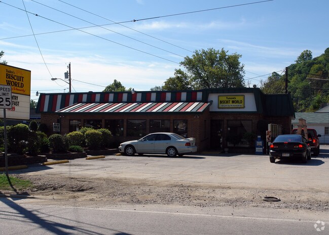
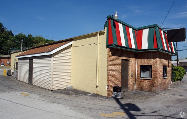
Property Record
113 W Main St, Saint Albans, WV 25177

NEARBY LISTINGS FOR SALE OR LEASE
Property Detail
113 W Main St
Charleston, WV
LT 1 MAIN ST BELOW COAL RIVER
16-6D-00530000
Kanawha
Restaurantdrivein
West Virginia
X
1
54079C0265D
0.29 AC
2025
Outlying Kanawha County
2025
Charleston WV
013702
DEMOGRAPHICS near 113 W Main St
1 Mile
3 Mile
5 Mile
2024 Total Population
5,822
25,401
41,765
2029 Population
5,660
24,597
40,543
Pop Growth 2024-2029
(2.78%)
(3.17%)
(2.93%)
Average Age
43
43
42
2024 Total Households
2,570
11,094
17,914
HH Growth 2024-2029
(2.92%)
(3.22%)
(2.99%)
Median Household Inc
$49,976
$53,103
$56,812
Avg Household Size
2.20
2.20
2.30
2024 Avg HH Vehicles
2.00
2.00
2.00
Median Home Value
$134,210
$132,608
$137,925
Median Year Built
1959
1960
1967
Nearby Places
Map Layers
Map Styles
 Street
 Aerial
- Restaurants
- Banks
- Shops
- Fitness
- Groceries
PUBLIC TRANSPORTATION
AIRPORT
West Virginia International Yeager
DRIVE
WALK
Distance
West Virginia International Yeager
32 min
18.8 mi
Freight Ports
Port of Toledo
DRIVE
WALK
Distance
Port of Toledo
366 min
286.7 mi
Nearby Properties
Address
Land Use
TOTAL SIZE
Lot Size
Zoning
Address
Land Use
TOTAL SIZE
Lot Size
Zoning
106.70 AC
Address
Land Use
TOTAL SIZE
Lot Size
Zoning
26.28 AC
Address
Land Use
TOTAL SIZE
Lot Size
Zoning
12.83 AC
Address
Land Use
TOTAL SIZE
Lot Size
Zoning
15.57 AC
Address
Land Use
TOTAL SIZE
Lot Size
Zoning
10.43 AC
Address
Land Use
TOTAL SIZE
Lot Size
Zoning
14.53 AC
Address
Land Use
TOTAL SIZE
Lot Size
Zoning
3.18 AC
Address
Land Use
TOTAL SIZE
Lot Size
Zoning
82.09 AC
Address
Land Use
TOTAL SIZE
Lot Size
Zoning
11.77 AC
Address
Land Use
TOTAL SIZE
Lot Size
Zoning
29.15 AC
Address
Land Use
TOTAL SIZE
Lot Size
Zoning
9.02 AC
Address
Land Use
TOTAL SIZE
Lot Size
Zoning
6.62 AC
Address
Land Use
TOTAL SIZE
Lot Size
Zoning
Address
Land Use
TOTAL SIZE
Lot Size
Zoning
7.55 AC
Address
Land Use
TOTAL SIZE
Lot Size
Zoning
Address
Land Use
TOTAL SIZE
Lot Size
Zoning
Address
Land Use
TOTAL SIZE
Lot Size
Zoning
3.98 AC
Address
Land Use
TOTAL SIZE
Lot Size
Zoning
Address
Land Use
TOTAL SIZE
Lot Size
Zoning
4.10 AC
Address
Land Use
TOTAL SIZE
Lot Size
Zoning
0.48 AC
Address
Land Use
TOTAL SIZE
Lot Size
Zoning
Address
Land Use
TOTAL SIZE
Lot Size
Zoning
31.26 AC
Address
Land Use
TOTAL SIZE
Lot Size
Zoning
23.87 AC
Address
Land Use
TOTAL SIZE
Lot Size
Zoning
1.14 AC
Address
Land Use
TOTAL SIZE
Lot Size
Zoning
52.74 AC
Address
Land Use
TOTAL SIZE
Lot Size
Zoning
39.16 AC
Address
Land Use
TOTAL SIZE
Lot Size
Zoning
8.86 AC
Address
Land Use
TOTAL SIZE
Lot Size
Zoning
5.80 AC
Address
Land Use
TOTAL SIZE
Lot Size
Zoning
Address
Land Use
TOTAL SIZE
Lot Size
Zoning
4.03 AC
The World's #1 Commercial Real Estate Marketplace
Connect with us
© 2026 CoStar Group
The information above has been obtained from sources believed reliable. While we do not doubt its accuracy we have not verified it and make no guarantee, warranty or representation about it. It is your responsibility to independently confirm its accuracy and completeness. Any projections, opinions, assumptions, or estimates used are for example only and do not represent the current or future performance of the property. The value of this transaction to you depends on tax and other factors which should be evaluated by your tax, financial, and legal advisors. You and your advisors should conduct a careful, independent investigation of the property to determine to your satisfaction the suitability of the property for your needs.