Property Record
1130 Capitol Trl, Newark, DE 19711


Property Detail
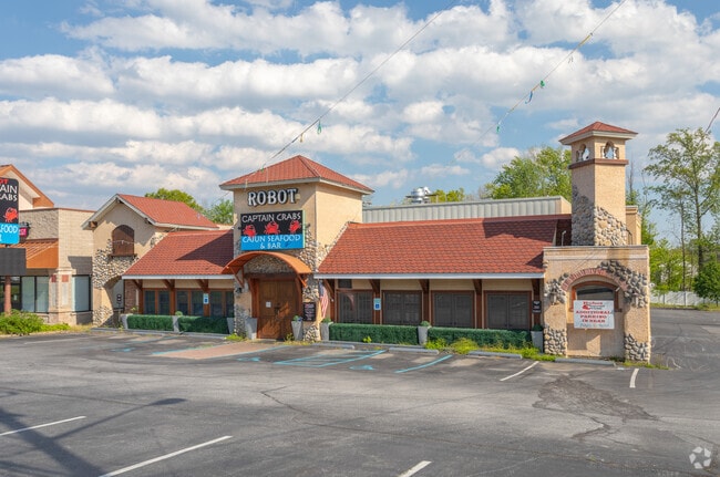
1130 Capitol Trl
08-060.10-094
BEG AT POINT ON SELY SIDE OF CAPITOL TRL ALSO KNOWN AS ROBERT KIRKWOODHWY AT VARYING WIDTHS
Restaurantbuilding
New Castle
CN
Delaware
B and X Area of moderate flood hazard, usually the area between the limits of the 100-year and 500-year floods.
1.11 AC
0
South New Castle County
2025
Philadelphia
013700
Philadelphia-Camden-Wilmington, PA-NJ-DE-MD
3,692 SF
NEARBY LISTINGS FOR SALE OR LEASE
DEMOGRAPHICS near 1130 Capitol Trl
1 mile
3 mile
5 mile
2025 Total Population
6,066
81,208
187,468
2030 Population
6,210
84,650
194,178
Pop Growth 2025-2030
+ 2.37%
+ 4.24%
+ 3.58%
Average Age
40
37
40
2025 Total Households
2,476
29,975
71,733
HH Growth 2025-2030
+ 2.54%
+ 4.34%
+ 3.73%
Median Household Inc
$80,187
$74,970
$86,334
Avg Household Size
2.40
2.40
2.40
2025 Avg HH Vehicles
2.00
2.00
2.00
Median Home Value
$319,297
$321,047
$338,526
Median Year Built
1968
1975
1979
Nearby Places
Map Layers
Map Styles
 Street
 Aerial
Layers
 Traffic
 Biking
Places
Listings with unknown addresses are not visible on the map
- Restaurants
- Banks
- Shops
- Fitness
- Groceries
PUBLIC TRANSPORTATION
COMMUTER RAIL
Churchmans Crossing (R2 - Southeastern Pennsylvania Transportation Authority Regional Rail (SEPTA Regional Rail))
Drive
Walk
Distance
Churchmans Crossing (R2 - Southeastern Pennsylvania Transportation Authority Regional Rail (SEPTA Regional Rail))
7 min
3.3 mi
Newark (R2 - Southeastern Pennsylvania Transportation Authority Regional Rail (SEPTA Regional Rail))
Drive
Walk
Distance
Newark (R2 - Southeastern Pennsylvania Transportation Authority Regional Rail (SEPTA Regional Rail))
8 min
3.9 mi
AIRPORT
Philadelphia International
Drive
Walk
Distance
Philadelphia International
46 min
32.8 mi
Freight Ports
Port of Wilmington, RI
Drive
Walk
Distance
Port of Wilmington, RI
20 min
12.8 mi
SALE & LEASE HISTORY
LISTING DATE
SALE/LEASE

Sep 25, 2016
For Lease
Sep 23, 2016
For Sale
Jan 07, 2019
For Lease
Jan 07, 2019
For Sale
Nearby Properties
Address
Land Use
TOTAL SIZE
Lot Size
Zoning
Address
Land Use
TOTAL SIZE
Lot Size
Zoning
525,757 SF
189.70 AC
NCPUD
Address
Land Use
TOTAL SIZE
Lot Size
Zoning
354.61 AC
18UN
Address
Land Use
TOTAL SIZE
Lot Size
Zoning
108,170 SF
111.08 AC
18UN
Address
Land Use
TOTAL SIZE
Lot Size
Zoning
169,544 SF
60.86 AC
OR
Address
Land Use
TOTAL SIZE
Lot Size
Zoning
488,637 SF
229.83 AC
NCPUD
Address
Land Use
TOTAL SIZE
Lot Size
Zoning
43,943 SF
8.95 AC
18BB
Address
Land Use
TOTAL SIZE
Lot Size
Zoning
80,834 SF
4.60 AC
18BB
Address
Land Use
TOTAL SIZE
Lot Size
Zoning
92,081 SF
30.99 AC
18RM
Address
Land Use
TOTAL SIZE
Lot Size
Zoning
Address
Land Use
TOTAL SIZE
Lot Size
Zoning
351,528 SF
24.88 AC
NCAP
Address
Land Use
TOTAL SIZE
Lot Size
Zoning
33,790 SF
45.17 AC
S
Address
Land Use
TOTAL SIZE
Lot Size
Zoning
54,907 SF
21.74 AC
18RA
Address
Land Use
TOTAL SIZE
Lot Size
Zoning
57,214 SF
1.10 AC
18BB
Address
Land Use
TOTAL SIZE
Lot Size
Zoning
118,400 SF
59.44 AC
S
Address
Land Use
TOTAL SIZE
Lot Size
Zoning
276,191 SF
54.91 AC
BP
Address
Land Use
TOTAL SIZE
Lot Size
Zoning
242,811 SF
38.77 AC
CR
Address
Land Use
TOTAL SIZE
Lot Size
Zoning
119,820 SF
19.86 AC
18UN
Address
Land Use
TOTAL SIZE
Lot Size
Zoning
27,576 SF
216.60 AC
S
Address
Land Use
TOTAL SIZE
Lot Size
Zoning
332,800 SF
18.70 AC
NCAP
Address
Land Use
TOTAL SIZE
Lot Size
Zoning
102,955 SF
9.57 AC
I
Address
Land Use
TOTAL SIZE
Lot Size
Zoning
108,553 SF
5.89 AC
18RM
Address
Land Use
TOTAL SIZE
Lot Size
Zoning
225,947 SF
18.68 AC
NCAP
Address
Land Use
TOTAL SIZE
Lot Size
Zoning
Address
Land Use
TOTAL SIZE
Lot Size
Zoning
21,243 SF
154.32 AC
OR
Address
Land Use
TOTAL SIZE
Lot Size
Zoning
1,815 SF
115.74 AC
S
Address
Land Use
TOTAL SIZE
Lot Size
Zoning
396,768 SF
11.96 AC
NCAP
Address
Land Use
TOTAL SIZE
Lot Size
Zoning
11.79 AC
18UN
Address
Land Use
TOTAL SIZE
Lot Size
Zoning
324,733 SF
13.10 AC
NCAP
Address
Land Use
TOTAL SIZE
Lot Size
Zoning
247,122 SF
30.25 AC
S
Address
Land Use
TOTAL SIZE
Lot Size
Zoning
81,845 SF
25.25 AC
CR
The World's #1 Commercial Real Estate Marketplace
Connect with us
© 2026 CoStar Group
The information above has been obtained from sources believed reliable. While we do not doubt its accuracy we have not verified it and make no guarantee, warranty or representation about it. It is your responsibility to independently confirm its accuracy and completeness. Any projections, opinions, assumptions, or estimates used are for example only and do not represent the current or future performance of the property. The value of this transaction to you depends on tax and other factors which should be evaluated by your tax, financial, and legal advisors. You and your advisors should conduct a careful, independent investigation of the property to determine to your satisfaction the suitability of the property for your needs.