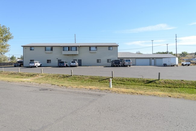
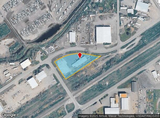
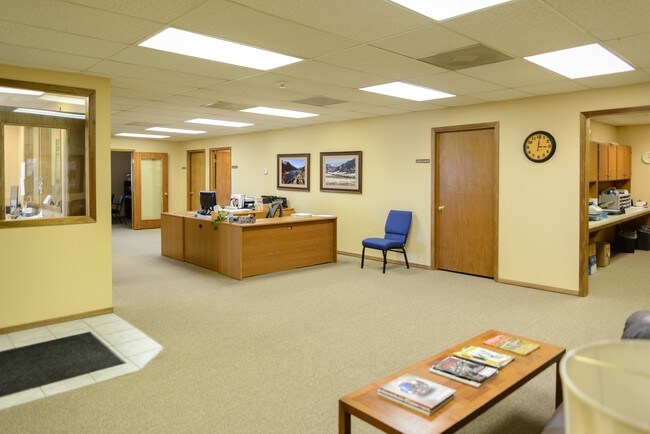
Property Record
1130 Cerise Rd, Billings, MT 59101
NEARBY LISTINGS FOR SALE OR LEASE
Property Detail
1130 Cerise Rd
03-1033-26-3-04-01-0000
S26, T01 N, R26 E, C.O.S. 1640, PARCEL 4, TR 4 COS 1640
Commercialnec
Yellowstone
X
Montana
30111C1290E
1.48 AC
2024
Billings
2025
Other Market Areas
000800
Billings, MT
11,755 SF
DEMOGRAPHICS near 1130 Cerise Rd
1 Mile
3 Mile
5 Mile
2024 Total Population
1,894
38,144
79,750
2029 Population
2,037
41,271
86,147
Pop Growth 2024-2029
+ 7.55%
+ 8.20%
+ 8.02%
Average Age
39
39
39
2024 Total Households
792
15,557
32,908
HH Growth 2024-2029
+ 7.70%
+ 8.37%
+ 8.17%
Median Household Inc
$56,999
$60,729
$64,700
Avg Household Size
2.30
2.30
2.30
2024 Avg HH Vehicles
2.00
2.00
2.00
Median Home Value
$217,544
$260,689
$268,717
Median Year Built
1981
1979
1974
Nearby Places
Map Layers
Map Styles
 Street
 Aerial
- Restaurants
- Banks
- Shops
- Fitness
- Groceries
PUBLIC TRANSPORTATION
AIRPORT
Billings Logan International
DRIVE
WALK
Distance
Billings Logan International
24 min
8.4 mi
Freight Ports
Port of Everett
DRIVE
WALK
Distance
Port of Everett
888 min
845.1 mi
SALE & LEASE HISTORY
LISTING DATE
SALE/LEASE

Sep 23, 2016
For Sale
Nearby Properties
Address
Land Use
TOTAL SIZE
Lot Size
Zoning
Address
Land Use
TOTAL SIZE
Lot Size
Zoning
704,701 SF
9.06 AC
MCPZD
Address
Land Use
TOTAL SIZE
Lot Size
Zoning
240,253 SF
282.66 AC
HI
Address
Land Use
TOTAL SIZE
Lot Size
Zoning
6,000 SF
152.47 AC
PUBLIC-COU
Address
Land Use
TOTAL SIZE
Lot Size
Zoning
198,096 SF
7.48 AC
MCPZD
Address
Land Use
TOTAL SIZE
Lot Size
Zoning
9.37 AC
P
Address
Land Use
TOTAL SIZE
Lot Size
Zoning
213,615 SF
0.96 AC
CBD
Address
Land Use
TOTAL SIZE
Lot Size
Zoning
76,098 SF
0.80 AC
CBD
Address
Land Use
TOTAL SIZE
Lot Size
Zoning
117,130 SF
29.86 AC
R-70
Address
Land Use
TOTAL SIZE
Lot Size
Zoning
108,000 SF
2.07 AC
CBD
Address
Land Use
TOTAL SIZE
Lot Size
Zoning
145,168 SF
0.96 AC
CBD
Address
Land Use
TOTAL SIZE
Lot Size
Zoning
71,600 SF
0.15 AC
CBD
Address
Land Use
TOTAL SIZE
Lot Size
Zoning
141,056 SF
25.82 AC
PUBLIC-CIT
Address
Land Use
TOTAL SIZE
Lot Size
Zoning
234,444 SF
4.98 AC
MCPZD
Address
Land Use
TOTAL SIZE
Lot Size
Zoning
63,650 SF
4.13 AC
MCPZD
Address
Land Use
TOTAL SIZE
Lot Size
Zoning
181,007 SF
19.57 AC
Address
Land Use
TOTAL SIZE
Lot Size
Zoning
141,186 SF
2.62 AC
CBD
Address
Land Use
TOTAL SIZE
Lot Size
Zoning
48,717 SF
1.53 AC
MCPZD
Address
Land Use
TOTAL SIZE
Lot Size
Zoning
125,400 SF
2.41 AC
CI
Address
Land Use
TOTAL SIZE
Lot Size
Zoning
90,220 SF
0.96 AC
CBD
Address
Land Use
TOTAL SIZE
Lot Size
Zoning
85,198 SF
0.48 AC
CBD
Address
Land Use
TOTAL SIZE
Lot Size
Zoning
108,563 SF
4.38 AC
CBD
Address
Land Use
TOTAL SIZE
Lot Size
Zoning
60.42 AC
HI
Address
Land Use
TOTAL SIZE
Lot Size
Zoning
205,302 SF
0.90 AC
CBD
Address
Land Use
TOTAL SIZE
Lot Size
Zoning
62,136 SF
2.24 AC
MCPZD
Address
Land Use
TOTAL SIZE
Lot Size
Zoning
74,990 SF
0.59 AC
CBD
Address
Land Use
TOTAL SIZE
Lot Size
Zoning
87,144 SF
3.65 AC
PZD
Address
Land Use
TOTAL SIZE
Lot Size
Zoning
68,022 SF
4.01 AC
CI
Address
Land Use
TOTAL SIZE
Lot Size
Zoning
45,955 SF
0.48 AC
CBD
Address
Land Use
TOTAL SIZE
Lot Size
Zoning
53.34 AC
P
Address
Land Use
TOTAL SIZE
Lot Size
Zoning
57,112 SF
7.69 AC
The World's #1 Commercial Real Estate Marketplace
Connect with us
© 2025 CoStar Group
The information above has been obtained from sources believed reliable. While we do not doubt its accuracy we have not verified it and make no guarantee, warranty or representation about it. It is your responsibility to independently confirm its accuracy and completeness. Any projections, opinions, assumptions, or estimates used are for example only and do not represent the current or future performance of the property. The value of this transaction to you depends on tax and other factors which should be evaluated by your tax, financial, and legal advisors. You and your advisors should conduct a careful, independent investigation of the property to determine to your satisfaction the suitability of the property for your needs.