Property Record
1130 Silas Deane Hwy, Wethersfield, CT 06109
NEARBY LISTINGS FOR SALE OR LEASE
Property Detail
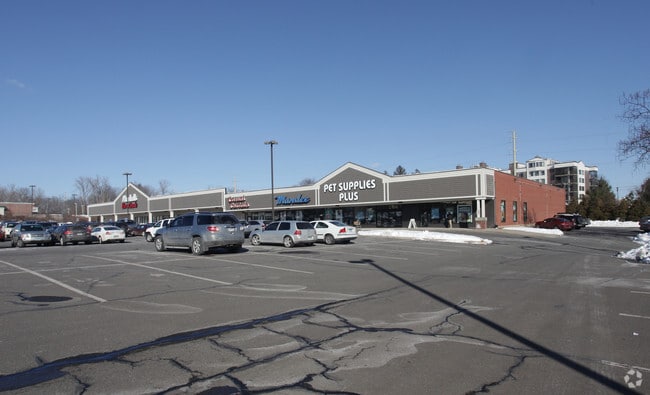
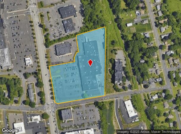
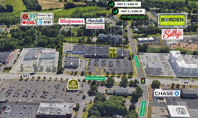
1130 Silas Deane Hwy
Regionalshoppingcenterormallwithanchorstore
Hartford
X
Connecticut
09003C0509F
6.66 AC
2025
Wethersfield
2025
Hartford
492600
Hartford-West Hartford-East Hartford, CT
76,090 SF
WETH-000239-000000-000011
DEMOGRAPHICS near 1130 Silas Deane Hwy
1 Mile
3 Mile
5 Mile
2024 Total Population
6,289
48,784
173,905
2029 Population
6,283
48,550
172,767
Pop Growth 2024-2029
(0.10%)
(0.48%)
(0.65%)
Average Age
44
43
41
2024 Total Households
2,809
20,492
69,507
HH Growth 2024-2029
+ 0.18%
(0.46%)
(0.67%)
Median Household Inc
$98,020
$96,140
$76,172
Avg Household Size
2.20
2.30
2.40
2024 Avg HH Vehicles
2.00
2.00
2.00
Median Home Value
$273,435
$277,935
$261,235
Median Year Built
1959
1965
1961
Nearby Places
Map Layers
Map Styles
 Street
 Aerial
- Restaurants
- Banks
- Shops
- Fitness
- Groceries
PUBLIC TRANSPORTATION
COMMUTER RAIL
Hartford (Hartford Line - Hartford Line)
DRIVE
WALK
Distance
Hartford (Hartford Line - Hartford Line)
12 min
6.9 mi
Hartford Amtrak Station (Amtrak Hartford Line - Amtrak, Northeast Regional - Amtrak, Valley Flyer - Amtrak, Vermonter - Amtrak)
DRIVE
WALK
Distance
Hartford Amtrak Station (Amtrak Hartford Line - Amtrak, Northeast Regional - Amtrak, Valley Flyer - Amtrak, Vermonter - Amtrak)
12 min
7.0 mi
AIRPORT
Bradley International
DRIVE
WALK
Distance
Bradley International
41 min
23.2 mi
Freight Ports
Port of New Haven
DRIVE
WALK
Distance
Port of New Haven
44 min
33.1 mi
SALE & LEASE HISTORY
LISTING DATE
SALE/LEASE

Mar 23, 2017
For Lease
Dec 14, 2022
For Lease
Apr 29, 2019
For Sale
Nearby Properties
Address
Land Use
TOTAL SIZE
Lot Size
Zoning
Address
Land Use
TOTAL SIZE
Lot Size
Zoning
81,507 SF
21.60 AC
R-20
Address
Land Use
TOTAL SIZE
Lot Size
Zoning
33.30 AC
R-20
Address
Land Use
TOTAL SIZE
Lot Size
Zoning
254,786 SF
36 AC
A
Address
Land Use
TOTAL SIZE
Lot Size
Zoning
3,416 SF
19.31 AC
SRD
Address
Land Use
TOTAL SIZE
Lot Size
Zoning
87,037 SF
10.44 AC
R-20
Address
Land Use
TOTAL SIZE
Lot Size
Zoning
116,979 SF
17 AC
B
Address
Land Use
TOTAL SIZE
Lot Size
Zoning
9.09 AC
R-20
Address
Land Use
TOTAL SIZE
Lot Size
Zoning
188,427 SF
8.55 AC
SRD
Address
Land Use
TOTAL SIZE
Lot Size
Zoning
129,065 SF
4.63 AC
MX-2
Address
Land Use
TOTAL SIZE
Lot Size
Zoning
Address
Land Use
TOTAL SIZE
Lot Size
Zoning
11.95 AC
PAD
Address
Land Use
TOTAL SIZE
Lot Size
Zoning
68,967 SF
11.25 AC
O
Address
Land Use
TOTAL SIZE
Lot Size
Zoning
15.12 AC
PAD
Address
Land Use
TOTAL SIZE
Lot Size
Zoning
10.45 AC
R-20
Address
Land Use
TOTAL SIZE
Lot Size
Zoning
83,468 SF
6.65 AC
R-20
Address
Land Use
TOTAL SIZE
Lot Size
Zoning
Address
Land Use
TOTAL SIZE
Lot Size
Zoning
145,956 SF
11.27 AC
OP
Address
Land Use
TOTAL SIZE
Lot Size
Zoning
13.85 AC
R-20
Address
Land Use
TOTAL SIZE
Lot Size
Zoning
8.14 AC
Address
Land Use
TOTAL SIZE
Lot Size
Zoning
13.61 AC
RC
Address
Land Use
TOTAL SIZE
Lot Size
Zoning
8.56 AC
TC
Address
Land Use
TOTAL SIZE
Lot Size
Zoning
186,777 SF
21.25 AC
RC
Address
Land Use
TOTAL SIZE
Lot Size
Zoning
158,692 SF
2.89 AC
PAD
Address
Land Use
TOTAL SIZE
Lot Size
Zoning
38.84 AC
RC
Address
Land Use
TOTAL SIZE
Lot Size
Zoning
105,294 SF
2.49 AC
PAD
Address
Land Use
TOTAL SIZE
Lot Size
Zoning
96,206 SF
2.83 AC
PAD
Address
Land Use
TOTAL SIZE
Lot Size
Zoning
75,478 SF
14.40 AC
A1
Address
Land Use
TOTAL SIZE
Lot Size
Zoning
175,694 SF
9.03 AC
BP
Address
Land Use
TOTAL SIZE
Lot Size
Zoning
3.06 AC
Address
Land Use
TOTAL SIZE
Lot Size
Zoning
97.02 AC
A1
The World's #1 Commercial Real Estate Marketplace
Connect with us
© 2025 CoStar Group
The information above has been obtained from sources believed reliable. While we do not doubt its accuracy we have not verified it and make no guarantee, warranty or representation about it. It is your responsibility to independently confirm its accuracy and completeness. Any projections, opinions, assumptions, or estimates used are for example only and do not represent the current or future performance of the property. The value of this transaction to you depends on tax and other factors which should be evaluated by your tax, financial, and legal advisors. You and your advisors should conduct a careful, independent investigation of the property to determine to your satisfaction the suitability of the property for your needs.