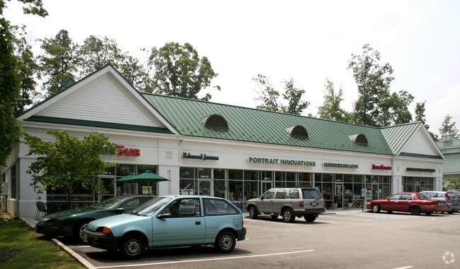
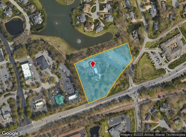
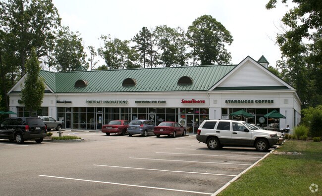
Property Record
11300 W Huguenot Rd, Midlothian, VA 23113
NEARBY LISTINGS FOR SALE OR LEASE
-
-
No Photo
-
-
-
-
View all Midlothian listings for sale on LoopNet.com
Property Detail
11300 W Huguenot Rd
742-71-66-01-300-000
Bellgrade Parcels 1 & 3
Religious
BELLGRADE PAR 1 & 3
X
Chesterfield
5101290015E
Virginia
2025
4.78 AC
2025
Stony Point/Huguenot
100926
Richmond VA
15,752 SF
Richmond, VA
DEMOGRAPHICS near 11300 W Huguenot Rd
1 Mile
3 Mile
5 Mile
2024 Total Population
8,231
46,134
135,579
2029 Population
8,960
49,932
145,176
Pop Growth 2024-2029
+ 8.86%
+ 8.23%
+ 7.08%
Average Age
43
43
42
2024 Total Households
3,444
18,334
53,007
HH Growth 2024-2029
+ 8.91%
+ 8.20%
+ 7.12%
Median Household Inc
$87,322
$98,720
$95,801
Avg Household Size
2.30
2.40
2.50
2024 Avg HH Vehicles
2.00
2.00
2.00
Median Home Value
$345,555
$346,067
$360,908
Median Year Built
1985
1981
1984
Nearby Places
Map Layers
Map Styles
 Street
 Aerial
- Restaurants
- Banks
- Shops
- Fitness
- Groceries
PUBLIC TRANSPORTATION
AIRPORT
Richmond International
DRIVE
WALK
Distance
Richmond International
35 min
21.4 mi
Freight Ports
Virginia Port Authority - Richmond
DRIVE
WALK
Distance
Virginia Port Authority - Richmond
27 min
13.3 mi
Nearby Properties
Address
Land Use
TOTAL SIZE
Lot Size
Zoning
Address
Land Use
TOTAL SIZE
Lot Size
Zoning
433,639 SF
72.37 AC
C3 - COMMU
Address
Land Use
TOTAL SIZE
Lot Size
Zoning
26.88 AC
MULTIPLE Z
Address
Land Use
TOTAL SIZE
Lot Size
Zoning
178,546 SF
28.35 AC
A - AGRICU
Address
Land Use
TOTAL SIZE
Lot Size
Zoning
96,480 SF
22.17 AC
RMF - RES,
Address
Land Use
TOTAL SIZE
Lot Size
Zoning
123,252 SF
48.88 AC
R7 - SINGL
Address
Land Use
TOTAL SIZE
Lot Size
Zoning
77,162 SF
26.28 AC
R-2 SINGLE
Address
Land Use
TOTAL SIZE
Lot Size
Zoning
71,849 SF
25 AC
RMF - RES,
Address
Land Use
TOTAL SIZE
Lot Size
Zoning
199,310 SF
1.15 AC
LAC2
Address
Land Use
TOTAL SIZE
Lot Size
Zoning
100 SF
27.09 AC
R7 - SINGL
Address
Land Use
TOTAL SIZE
Lot Size
Zoning
235,098 SF
37.52 AC
R-2 SINGLE
Address
Land Use
TOTAL SIZE
Lot Size
Zoning
77,657 SF
27.17 AC
R7 - SINGL
Address
Land Use
TOTAL SIZE
Lot Size
Zoning
100 SF
15 AC
C4 - REGIO
Address
Land Use
TOTAL SIZE
Lot Size
Zoning
100 SF
9.79 AC
C4 - REGIO
Address
Land Use
TOTAL SIZE
Lot Size
Zoning
106,256 SF
18.66 AC
R7 - SINGL
Address
Land Use
TOTAL SIZE
Lot Size
Zoning
174,840 SF
21.13 AC
R7 - SINGL
Address
Land Use
TOTAL SIZE
Lot Size
Zoning
768 SF
49.45 AC
R40 - SING
Address
Land Use
TOTAL SIZE
Lot Size
Zoning
95,944 SF
14.76 AC
A - AGRICU
Address
Land Use
TOTAL SIZE
Lot Size
Zoning
102,600 SF
8.38 AC
R-2 SINGLE
Address
Land Use
TOTAL SIZE
Lot Size
Zoning
118,712 SF
16.25 AC
C3 - COMMU
Address
Land Use
TOTAL SIZE
Lot Size
Zoning
93,846 SF
10.42 AC
R15 - SING
Address
Land Use
TOTAL SIZE
Lot Size
Zoning
132,784 SF
6.33 AC
O2 - CORP
Address
Land Use
TOTAL SIZE
Lot Size
Zoning
36,237 SF
16.67 AC
C3 - COMMU
Address
Land Use
TOTAL SIZE
Lot Size
Zoning
86,166 SF
10.09 AC
R-2 SINGLE
Address
Land Use
TOTAL SIZE
Lot Size
Zoning
206,183 SF
25.21 AC
C3 - COMMU
Address
Land Use
TOTAL SIZE
Lot Size
Zoning
66,768 SF
5.52 AC
R-2 SINGLE
Address
Land Use
TOTAL SIZE
Lot Size
Zoning
4.45 AC
RMF - RES,
Address
Land Use
TOTAL SIZE
Lot Size
Zoning
12,309 SF
14.20 AC
C3 - COMMU
Address
Land Use
TOTAL SIZE
Lot Size
Zoning
51,553 SF
30 AC
R-1 SINGLE
Address
Land Use
TOTAL SIZE
Lot Size
Zoning
51,683 SF
3.31 AC
I1 - LT IN
Address
Land Use
TOTAL SIZE
Lot Size
Zoning
5,680 SF
6.75 AC
C2 - NBHD
The World's #1 Commercial Real Estate Marketplace
Connect with us
© 2025 CoStar Group
The information above has been obtained from sources believed reliable. While we do not doubt its accuracy we have not verified it and make no guarantee, warranty or representation about it. It is your responsibility to independently confirm its accuracy and completeness. Any projections, opinions, assumptions, or estimates used are for example only and do not represent the current or future performance of the property. The value of this transaction to you depends on tax and other factors which should be evaluated by your tax, financial, and legal advisors. You and your advisors should conduct a careful, independent investigation of the property to determine to your satisfaction the suitability of the property for your needs.