Property Record
11301 Highway 72 W, Centerton, AR 72719
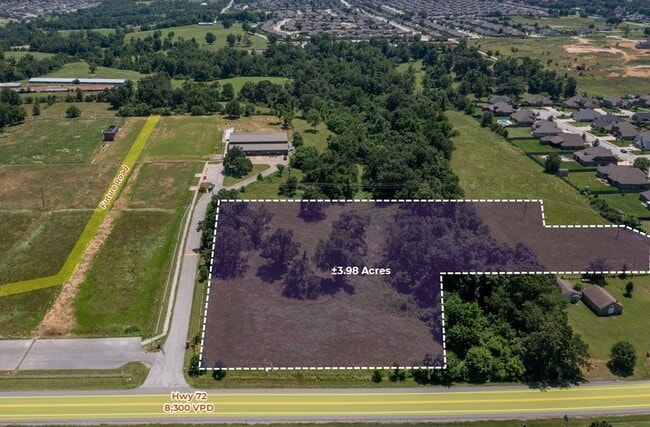


This Property Is For Sale
Property Detail
11301 Highway 72 W
06-00047-355
A PART OF THE NORTHEAST QUARTER OF THE SOUTHEAST QUARTER OF SECTION 28 TOWNSHIP 20 NORTH, RANGE 31 WEST BENTON COUNTY ARKANSAS BEING MORE PARTICULARLY DESCRIBED AS FOLLOWS TO-WIT: COMMENCING AT AN EXISTING STONE MARKING THE SOUTHEAST CORNER OF THE NO
Gymhealthspa
BENTON
B and X Area of moderate flood hazard, usually the area between the limits of the 100-year and 500-year floods.
Arkansas
2025
22.65 AC
2025
Outlying Benton County
020904
Fayetteville/Springdale/Rogers
12,600 SF
Fayetteville-Springdale-Rogers, AR
NEARBY LISTINGS FOR SALE OR LEASE
DEMOGRAPHICS near 11301 Highway 72 W
1 mile
3 mile
5 mile
2025 Total Population
4,819
38,557
83,011
2030 Population
5,341
42,884
92,506
Pop Growth 2025-2030
+ 10.83%
+ 11.22%
+ 11.44%
Average Age
34
34
35
2025 Total Households
1,561
13,440
30,348
HH Growth 2025-2030
+ 11.08%
+ 11.53%
+ 11.76%
Median Household Inc
$150,209
$118,452
$115,181
Avg Household Size
3.10
2.80
2.70
2025 Avg HH Vehicles
2.00
2.00
2.00
Median Home Value
$392,640
$411,185
$430,283
Median Year Built
2007
2007
2007
Nearby Places
Map Layers
Map Styles
 Street
 Aerial
Layers
 Traffic
 Biking
Places
Listings with unknown addresses are not visible on the map
- Restaurants
- Banks
- Shops
- Fitness
- Groceries
PUBLIC TRANSPORTATION
AIRPORT
Northwest Arkansas Ntl
Drive
Walk
Distance
Northwest Arkansas Ntl
22 min
9.2 mi
Nearby Properties
Address
Land Use
TOTAL SIZE
Lot Size
Zoning
Address
Land Use
TOTAL SIZE
Lot Size
Zoning
254,163 SF
10.98 AC
Address
Land Use
TOTAL SIZE
Lot Size
Zoning
218,437 SF
17.90 AC
Address
Land Use
TOTAL SIZE
Lot Size
Zoning
199,773 SF
14.09 AC
Address
Land Use
TOTAL SIZE
Lot Size
Zoning
290,030 SF
Address
Land Use
TOTAL SIZE
Lot Size
Zoning
239,145 SF
32.91 AC
Address
Land Use
TOTAL SIZE
Lot Size
Zoning
21,846 SF
10.20 AC
Address
Land Use
TOTAL SIZE
Lot Size
Zoning
147,832 SF
21.01 AC
Address
Land Use
TOTAL SIZE
Lot Size
Zoning
57,290 SF
5 AC
Address
Land Use
TOTAL SIZE
Lot Size
Zoning
42,483 SF
7.30 AC
Address
Land Use
TOTAL SIZE
Lot Size
Zoning
74,368 SF
4.76 AC
Address
Land Use
TOTAL SIZE
Lot Size
Zoning
61,320 SF
1.78 AC
Address
Land Use
TOTAL SIZE
Lot Size
Zoning
50,779 SF
2.58 AC
Address
Land Use
TOTAL SIZE
Lot Size
Zoning
70,244 SF
6.69 AC
Address
Land Use
TOTAL SIZE
Lot Size
Zoning
96,719 SF
9.12 AC
Address
Land Use
TOTAL SIZE
Lot Size
Zoning
70,283 SF
4.79 AC
Address
Land Use
TOTAL SIZE
Lot Size
Zoning
11,067 SF
3.11 AC
Address
Land Use
TOTAL SIZE
Lot Size
Zoning
81,020 SF
5.37 AC
Address
Land Use
TOTAL SIZE
Lot Size
Zoning
86,153 SF
5 AC
Address
Land Use
TOTAL SIZE
Lot Size
Zoning
66,750 SF
5.54 AC
Address
Land Use
TOTAL SIZE
Lot Size
Zoning
49,880 SF
5.34 AC
Address
Land Use
TOTAL SIZE
Lot Size
Zoning
46,442 SF
5.27 AC
Address
Land Use
TOTAL SIZE
Lot Size
Zoning
10,988 SF
1.11 AC
Address
Land Use
TOTAL SIZE
Lot Size
Zoning
40,788 SF
2.98 AC
Address
Land Use
TOTAL SIZE
Lot Size
Zoning
17,576 SF
2.77 AC
Address
Land Use
TOTAL SIZE
Lot Size
Zoning
25,000 SF
2.16 AC
Address
Land Use
TOTAL SIZE
Lot Size
Zoning
19,320 SF
4 AC
Address
Land Use
TOTAL SIZE
Lot Size
Zoning
7,346 SF
3.85 AC
Address
Land Use
TOTAL SIZE
Lot Size
Zoning
25.27 AC
Address
Land Use
TOTAL SIZE
Lot Size
Zoning
14,138 SF
2.15 AC
Address
Land Use
TOTAL SIZE
Lot Size
Zoning
20.58 AC
The World's #1 Commercial Real Estate Marketplace
Connect with us
© 2026 CoStar Group
The information above has been obtained from sources believed reliable. While we do not doubt its accuracy we have not verified it and make no guarantee, warranty or representation about it. It is your responsibility to independently confirm its accuracy and completeness. Any projections, opinions, assumptions, or estimates used are for example only and do not represent the current or future performance of the property. The value of this transaction to you depends on tax and other factors which should be evaluated by your tax, financial, and legal advisors. You and your advisors should conduct a careful, independent investigation of the property to determine to your satisfaction the suitability of the property for your needs.