Property Record
11301 Redpoint Dr, Las Vegas, NV 89138

Property Detail
11301 Redpoint Dr
Las Vegas-Henderson-North Las Vegas, NV
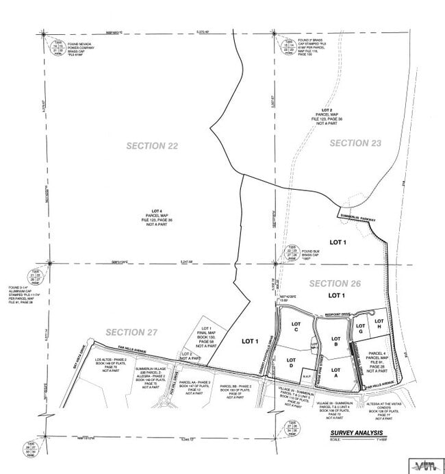
SUMMERLIN VILLAGE 21 UNIT 1-LARGE LOT FINAL MAP PLAT BOOK 158 PAGE 87 LOT G
137-26-212-005
CLARK
Governmentalpublicusegeneral
Nevada
B and X Area of moderate flood hazard, usually the area between the limits of the 100-year and 500-year floods.
g
0
4.97 AC
2026
Northwest Las Vegas
005872
Las Vegas
23,260 SF
NEARBY LISTINGS FOR SALE OR LEASE
-
-
View all Las Vegas listings for sale on LoopNet.com
DEMOGRAPHICS near 11301 Redpoint Dr
1 mile
3 mile
5 mile
2025 Total Population
14,783
86,796
230,836
2030 Population
15,868
92,601
243,169
Pop Growth 2025-2030
+ 7.34%
+ 6.69%
+ 5.34%
Average Age
42
44
44
2025 Total Households
5,495
35,533
95,303
HH Growth 2025-2030
+ 7.21%
+ 6.52%
+ 5.29%
Median Household Inc
$138,970
$113,952
$92,341
Avg Household Size
2.70
2.40
2.40
2025 Avg HH Vehicles
2.00
2.00
2.00
Median Home Value
$731,957
$650,188
$511,637
Median Year Built
2005
2001
1996
Nearby Places
Map Layers
Map Styles
 Street
 Aerial
Layers
 Traffic
 Biking
Places
Listings with unknown addresses are not visible on the map
- Restaurants
- Banks
- Shops
- Fitness
- Groceries
PUBLIC TRANSPORTATION
AIRPORT
Harry Reid International
Drive
Walk
Distance
Harry Reid International
26 min
19.6 mi
Freight Ports
Port of Long Beach
Drive
Walk
Distance
Port of Long Beach
327 min
291.3 mi
Nearby Properties
Address
Land Use
TOTAL SIZE
Lot Size
Zoning
Address
Land Use
TOTAL SIZE
Lot Size
Zoning
421,874 SF
59.43 AC
H1
Address
Land Use
TOTAL SIZE
Lot Size
Zoning
157,011 SF
31.41 AC
Address
Land Use
TOTAL SIZE
Lot Size
Zoning
42.15 AC
PF
Address
Land Use
TOTAL SIZE
Lot Size
Zoning
100.61 AC
Address
Land Use
TOTAL SIZE
Lot Size
Zoning
29,374 SF
7.06 AC
Address
Land Use
TOTAL SIZE
Lot Size
Zoning
40.55 AC
PC
Address
Land Use
TOTAL SIZE
Lot Size
Zoning
38.56 AC
PF
Address
Land Use
TOTAL SIZE
Lot Size
Zoning
280,968 SF
1.45 AC
Address
Land Use
TOTAL SIZE
Lot Size
Zoning
52,690 SF
17.65 AC
RU
Address
Land Use
TOTAL SIZE
Lot Size
Zoning
41,331 SF
1.59 AC
Address
Land Use
TOTAL SIZE
Lot Size
Zoning
Address
Land Use
TOTAL SIZE
Lot Size
Zoning
6,825 SF
9.11 AC
Address
Land Use
TOTAL SIZE
Lot Size
Zoning
3,520 SF
28.42 AC
R3
Address
Land Use
TOTAL SIZE
Lot Size
Zoning
15,405 SF
16.74 AC
Address
Land Use
TOTAL SIZE
Lot Size
Zoning
5,427 SF
17.57 AC
Address
Land Use
TOTAL SIZE
Lot Size
Zoning
259,832 SF
3.79 AC
Address
Land Use
TOTAL SIZE
Lot Size
Zoning
44.60 AC
Address
Land Use
TOTAL SIZE
Lot Size
Zoning
52.29 AC
Address
Land Use
TOTAL SIZE
Lot Size
Zoning
3.66 AC
R3
Address
Land Use
TOTAL SIZE
Lot Size
Zoning
246,947 SF
6.56 AC
RU
Address
Land Use
TOTAL SIZE
Lot Size
Zoning
30.07 AC
Address
Land Use
TOTAL SIZE
Lot Size
Zoning
3,895 SF
15.40 AC
PC
Address
Land Use
TOTAL SIZE
Lot Size
Zoning
12,031 SF
17.45 AC
PC
Address
Land Use
TOTAL SIZE
Lot Size
Zoning
450 SF
48.82 AC
Address
Land Use
TOTAL SIZE
Lot Size
Zoning
242,467 SF
6.09 AC
C:C-2
Address
Land Use
TOTAL SIZE
Lot Size
Zoning
151,168 SF
4.65 AC
Address
Land Use
TOTAL SIZE
Lot Size
Zoning
151,550 SF
4.50 AC
Address
Land Use
TOTAL SIZE
Lot Size
Zoning
7,191 SF
16.56 AC
PC
Address
Land Use
TOTAL SIZE
Lot Size
Zoning
27.17 AC
The World's #1 Commercial Real Estate Marketplace
Connect with us
© 2026 CoStar Group
The information above has been obtained from sources believed reliable. While we do not doubt its accuracy we have not verified it and make no guarantee, warranty or representation about it. It is your responsibility to independently confirm its accuracy and completeness. Any projections, opinions, assumptions, or estimates used are for example only and do not represent the current or future performance of the property. The value of this transaction to you depends on tax and other factors which should be evaluated by your tax, financial, and legal advisors. You and your advisors should conduct a careful, independent investigation of the property to determine to your satisfaction the suitability of the property for your needs.