Property Record
11302 W Broadway Rd, Tolleson, AZ 85353
NEARBY LISTINGS FOR SALE OR LEASE
Property Detail
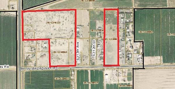
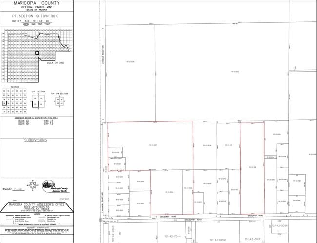
11302 W Broadway Rd
101-23-006A
S 324F W 200F OF FOL LOT 4 /SW4 SW4/ EX S2 & EX W 99F & EX S 182F
Residentialacreage
Maricopa
AE
Arizona
04013C2170N
4
2025
5.99 AC
2025
Glendale
082207
Phoenix
288 SF
Phoenix-Mesa-Scottsdale, AZ
DEMOGRAPHICS near 11302 W Broadway Rd
1 Mile
3 Mile
5 Mile
2024 Total Population
4,125
62,511
136,611
2029 Population
4,571
67,630
147,998
Pop Growth 2024-2029
+ 10.81%
+ 8.19%
+ 8.34%
Average Age
33
32
33
2024 Total Households
1,070
16,733
38,949
HH Growth 2024-2029
+ 10.93%
+ 8.34%
+ 8.45%
Median Household Inc
$89,226
$83,456
$73,468
Avg Household Size
3.70
3.60
3.40
2024 Avg HH Vehicles
3.00
2.00
2.00
Median Home Value
$350,000
$312,790
$308,827
Median Year Built
2006
2005
2003
Nearby Places
Map Layers
Map Styles
 Street
 Aerial
- Restaurants
- Banks
- Shops
- Fitness
- Groceries
PUBLIC TRANSPORTATION
AIRPORT
Phoenix Sky Harbor International
DRIVE
WALK
Distance
Phoenix Sky Harbor International
32 min
23.4 mi
Freight Ports
Port of San Diego
DRIVE
WALK
Distance
Port of San Diego
385 min
345.1 mi
SALE & LEASE HISTORY
LISTING DATE
SALE/LEASE

Sep 24, 2016
For Sale
Nearby Properties
Address
Land Use
TOTAL SIZE
Lot Size
Zoning
Address
Land Use
TOTAL SIZE
Lot Size
Zoning
12.80 AC
Address
Land Use
TOTAL SIZE
Lot Size
Zoning
206.08 AC
PAD
Address
Land Use
TOTAL SIZE
Lot Size
Zoning
134.65 AC
S1
Address
Land Use
TOTAL SIZE
Lot Size
Zoning
90,008 SF
20.42 AC
M-H
Address
Land Use
TOTAL SIZE
Lot Size
Zoning
270,919 SF
281.46 AC
MSED
Address
Land Use
TOTAL SIZE
Lot Size
Zoning
301,329 SF
50.60 AC
AG
Address
Land Use
TOTAL SIZE
Lot Size
Zoning
763,410 SF
45.50 AC
Address
Land Use
TOTAL SIZE
Lot Size
Zoning
797,310 SF
36.82 AC
I-1
Address
Land Use
TOTAL SIZE
Lot Size
Zoning
397,132 SF
27.52 AC
I1
Address
Land Use
TOTAL SIZE
Lot Size
Zoning
78 AC
AG
Address
Land Use
TOTAL SIZE
Lot Size
Zoning
13.45 AC
Address
Land Use
TOTAL SIZE
Lot Size
Zoning
29,210 SF
116.52 AC
S1
Address
Land Use
TOTAL SIZE
Lot Size
Zoning
291,805 SF
16.48 AC
PAD
Address
Land Use
TOTAL SIZE
Lot Size
Zoning
90,516 SF
18.66 AC
R-6
Address
Land Use
TOTAL SIZE
Lot Size
Zoning
174,400 SF
17.83 AC
PCD
Address
Land Use
TOTAL SIZE
Lot Size
Zoning
285,131 SF
16.11 AC
I-1
Address
Land Use
TOTAL SIZE
Lot Size
Zoning
508,510 SF
19.98 AC
I-1
Address
Land Use
TOTAL SIZE
Lot Size
Zoning
93,605 SF
10.99 AC
PAD
Address
Land Use
TOTAL SIZE
Lot Size
Zoning
321,892 SF
18.64 AC
CPGCP
Address
Land Use
TOTAL SIZE
Lot Size
Zoning
90,559 SF
13.43 AC
R-43AG
Address
Land Use
TOTAL SIZE
Lot Size
Zoning
91,648 SF
7.46 AC
PAD
Address
Land Use
TOTAL SIZE
Lot Size
Zoning
85,593 SF
13.76 AC
PAD
Address
Land Use
TOTAL SIZE
Lot Size
Zoning
272,456 SF
14.52 AC
Address
Land Use
TOTAL SIZE
Lot Size
Zoning
84,630 SF
10.31 AC
AG
Address
Land Use
TOTAL SIZE
Lot Size
Zoning
246,997 SF
17.56 AC
Address
Land Use
TOTAL SIZE
Lot Size
Zoning
71,181 SF
7.42 AC
R-8
Address
Land Use
TOTAL SIZE
Lot Size
Zoning
288,089 SF
18.22 AC
I-1
Address
Land Use
TOTAL SIZE
Lot Size
Zoning
228,134 SF
14.09 AC
PAD
Address
Land Use
TOTAL SIZE
Lot Size
Zoning
136,818 SF
37.34 AC
I2
The World's #1 Commercial Real Estate Marketplace
Connect with us
© 2025 CoStar Group
The information above has been obtained from sources believed reliable. While we do not doubt its accuracy we have not verified it and make no guarantee, warranty or representation about it. It is your responsibility to independently confirm its accuracy and completeness. Any projections, opinions, assumptions, or estimates used are for example only and do not represent the current or future performance of the property. The value of this transaction to you depends on tax and other factors which should be evaluated by your tax, financial, and legal advisors. You and your advisors should conduct a careful, independent investigation of the property to determine to your satisfaction the suitability of the property for your needs.