Property Record
11309 Georgetown Pike, Great Falls, VA 22066

NEARBY LISTINGS FOR SALE OR LEASE
-
-
View all Great Falls listings for sale on LoopNet.com
Property Detail
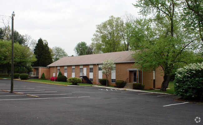
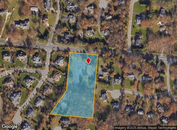
11309 Georgetown Pike
Washington-Arlington-Alexandria, DC-VA-MD-WV
Dranesville
0112-01-0025
DRANESVILLE CHURCH
Religious
Fairfax
X
Virginia
51059C0130E
25
0
5.03 AC
2025
Great Falls
480401
Washington, DC
7,418 SF
DEMOGRAPHICS near 11309 Georgetown Pike
1 Mile
3 Mile
5 Mile
2024 Total Population
4,236
69,145
211,704
2029 Population
4,148
69,316
215,685
Pop Growth 2024-2029
(2.08%)
+ 0.25%
+ 1.88%
Average Age
43
41
39
2024 Total Households
1,429
25,898
76,962
HH Growth 2024-2029
(2.17%)
(0.04%)
+ 1.71%
Median Household Inc
$244,614
$157,702
$139,815
Avg Household Size
2.90
2.60
2.70
2024 Avg HH Vehicles
3.00
2.00
2.00
Median Home Value
$1,016,040
$730,484
$646,465
Median Year Built
1991
1985
1986
Nearby Places
Map Layers
Map Styles
 Street
 Aerial
- Restaurants
- Banks
- Shops
- Fitness
- Groceries
PUBLIC TRANSPORTATION
AIRPORT
Washington Dulles International
DRIVE
WALK
Distance
Washington Dulles International
22 min
10.3 mi
Ronald Reagan Washington Ntl
DRIVE
WALK
Distance
Ronald Reagan Washington Ntl
39 min
24.6 mi
Freight Ports
Port of Baltimore
DRIVE
WALK
Distance
Port of Baltimore
76 min
56.4 mi
Nearby Properties
Address
Land Use
TOTAL SIZE
Lot Size
Zoning
Address
Land Use
TOTAL SIZE
Lot Size
Zoning
275,809 SF
0.75 AC
373
Address
Land Use
TOTAL SIZE
Lot Size
Zoning
560,356 SF
4.33 AC
372
Address
Land Use
TOTAL SIZE
Lot Size
Zoning
407,812 SF
33.12 AC
373
Address
Land Use
TOTAL SIZE
Lot Size
Zoning
337,921 SF
13.57 AC
373
Address
Land Use
TOTAL SIZE
Lot Size
Zoning
223,230 SF
400
Address
Land Use
TOTAL SIZE
Lot Size
Zoning
408,760 SF
87.24 AC
R1
Address
Land Use
TOTAL SIZE
Lot Size
Zoning
200,486 SF
400
Address
Land Use
TOTAL SIZE
Lot Size
Zoning
265,650 SF
13.11 AC
373
Address
Land Use
TOTAL SIZE
Lot Size
Zoning
234,679 SF
14.33 AC
372
Address
Land Use
TOTAL SIZE
Lot Size
Zoning
195,655 SF
10.41 AC
372
Address
Land Use
TOTAL SIZE
Lot Size
Zoning
334,952 SF
11.41 AC
373
Address
Land Use
TOTAL SIZE
Lot Size
Zoning
261,843 SF
21.88 AC
305
Address
Land Use
TOTAL SIZE
Lot Size
Zoning
202,220 SF
2.26 AC
372
Address
Land Use
TOTAL SIZE
Lot Size
Zoning
105,145 SF
8.64 AC
373
Address
Land Use
TOTAL SIZE
Lot Size
Zoning
310,310 SF
40.67 AC
130
Address
Land Use
TOTAL SIZE
Lot Size
Zoning
233,842 SF
12.50 AC
820
Address
Land Use
TOTAL SIZE
Lot Size
Zoning
227,448 SF
20.07 AC
820
Address
Land Use
TOTAL SIZE
Lot Size
Zoning
124,684 SF
12.82 AC
373
Address
Land Use
TOTAL SIZE
Lot Size
Zoning
192,018 SF
10.89 AC
373
Address
Land Use
TOTAL SIZE
Lot Size
Zoning
241,188 SF
9.10 AC
373
Address
Land Use
TOTAL SIZE
Lot Size
Zoning
103,617 SF
8.88 AC
373
Address
Land Use
TOTAL SIZE
Lot Size
Zoning
259,374 SF
22 AC
CCSC
Address
Land Use
TOTAL SIZE
Lot Size
Zoning
166,646 SF
9.53 AC
CCSC
Address
Land Use
TOTAL SIZE
Lot Size
Zoning
192,940 SF
7.41 AC
373
Address
Land Use
TOTAL SIZE
Lot Size
Zoning
125,643 SF
7.94 AC
CCSC
Address
Land Use
TOTAL SIZE
Lot Size
Zoning
215,742 SF
13.11 AC
373
Address
Land Use
TOTAL SIZE
Lot Size
Zoning
112,230 SF
8.50 AC
R16
Address
Land Use
TOTAL SIZE
Lot Size
Zoning
85,600 SF
10.29 AC
CCSC
Address
Land Use
TOTAL SIZE
Lot Size
Zoning
75,131 SF
13.89 AC
804
Address
Land Use
TOTAL SIZE
Lot Size
Zoning
3,757 SF
292.69 AC
100
The World's #1 Commercial Real Estate Marketplace
Connect with us
© 2025 CoStar Group
The information above has been obtained from sources believed reliable. While we do not doubt its accuracy we have not verified it and make no guarantee, warranty or representation about it. It is your responsibility to independently confirm its accuracy and completeness. Any projections, opinions, assumptions, or estimates used are for example only and do not represent the current or future performance of the property. The value of this transaction to you depends on tax and other factors which should be evaluated by your tax, financial, and legal advisors. You and your advisors should conduct a careful, independent investigation of the property to determine to your satisfaction the suitability of the property for your needs.