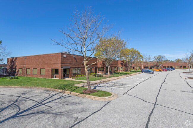
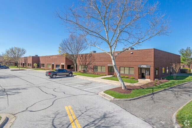
Property Record
1121 Benfield Blvd, Millersville, MD 21108

NEARBY LISTINGS FOR SALE OR LEASE
Property Detail
1121 Benfield Blvd
Baltimore-Columbia-Towson, MD
I-97 Business Park
04-000-90070353
LT 2 OR 19.708 ACRES I-97 BUSINESS PARK
Warehouse
Anne Arundel
X
Maryland
24003C0134E
2
2024
18.70 AC
2025
I-97/Crain Hwy Corrid
741000
Baltimore
128,466 SF
DEMOGRAPHICS near 1121 Benfield Blvd
1 Mile
3 Mile
5 Mile
2024 Total Population
1,392
49,714
181,574
2029 Population
1,409
50,853
185,730
Pop Growth 2024-2029
+ 1.22%
+ 2.29%
+ 2.29%
Average Age
41
40
39
2024 Total Households
476
18,195
67,111
HH Growth 2024-2029
+ 1.26%
+ 2.34%
+ 2.38%
Median Household Inc
$161,144
$111,402
$108,240
Avg Household Size
2.90
2.70
2.60
2024 Avg HH Vehicles
2.00
2.00
2.00
Median Home Value
$681,476
$478,165
$406,043
Median Year Built
1981
1980
1985
Nearby Places
Map Layers
Map Styles
 Street
 Aerial
- Restaurants
- Banks
- Shops
- Fitness
- Groceries
PUBLIC TRANSPORTATION
COMMUTER RAIL
Odenton (Penn Line - Maryland Area Regional Commuter Trains (The MARC))
DRIVE
WALK
Distance
Odenton (Penn Line - Maryland Area Regional Commuter Trains (The MARC))
13 min
6.6 mi
AIRPORT
Baltimore/Washington International Thurgood Marshall
DRIVE
WALK
Distance
Baltimore/Washington International Thurgood Marshall
18 min
10.6 mi
Ronald Reagan Washington Ntl
DRIVE
WALK
Distance
Ronald Reagan Washington Ntl
52 min
34.7 mi
Freight Ports
Port of Baltimore
DRIVE
WALK
Distance
Port of Baltimore
24 min
15.9 mi
SALE & LEASE HISTORY
LISTING DATE
SALE/LEASE

Sep 17, 2019
For Lease
Nearby Properties
Address
Land Use
TOTAL SIZE
Lot Size
Zoning
Address
Land Use
TOTAL SIZE
Lot Size
Zoning
851,355 SF
172.49 AC
R5
Address
Land Use
TOTAL SIZE
Lot Size
Zoning
356,600 SF
21.37 AC
R5
Address
Land Use
TOTAL SIZE
Lot Size
Zoning
14.65 AC
R15
Address
Land Use
TOTAL SIZE
Lot Size
Zoning
311,870 SF
10.03 AC
Address
Land Use
TOTAL SIZE
Lot Size
Zoning
11.57 AC
R22
Address
Land Use
TOTAL SIZE
Lot Size
Zoning
277,037 SF
10.45 AC
R5
Address
Land Use
TOTAL SIZE
Lot Size
Zoning
15.33 AC
R15
Address
Land Use
TOTAL SIZE
Lot Size
Zoning
21.45 AC
R15
Address
Land Use
TOTAL SIZE
Lot Size
Zoning
14.53 AC
R22
Address
Land Use
TOTAL SIZE
Lot Size
Zoning
14.58 AC
R22
Address
Land Use
TOTAL SIZE
Lot Size
Zoning
18.93 AC
R15
Address
Land Use
TOTAL SIZE
Lot Size
Zoning
9.45 AC
R22
Address
Land Use
TOTAL SIZE
Lot Size
Zoning
14.70 AC
R15
Address
Land Use
TOTAL SIZE
Lot Size
Zoning
342,464 SF
22.95 AC
O-IND
Address
Land Use
TOTAL SIZE
Lot Size
Zoning
0.34 AC
R22
Address
Land Use
TOTAL SIZE
Lot Size
Zoning
7.64 AC
R15
Address
Land Use
TOTAL SIZE
Lot Size
Zoning
6.95 AC
R15
Address
Land Use
TOTAL SIZE
Lot Size
Zoning
139,230 SF
39.22 AC
R2
Address
Land Use
TOTAL SIZE
Lot Size
Zoning
154,056 SF
19.89 AC
R2
Address
Land Use
TOTAL SIZE
Lot Size
Zoning
50.82 AC
R5
Address
Land Use
TOTAL SIZE
Lot Size
Zoning
103,276 SF
20.89 AC
C3
Address
Land Use
TOTAL SIZE
Lot Size
Zoning
98,109 SF
5.33 AC
C2
Address
Land Use
TOTAL SIZE
Lot Size
Zoning
46,896 SF
3.29 AC
C1B
Address
Land Use
TOTAL SIZE
Lot Size
Zoning
95,311 SF
3.84 AC
C4
Address
Land Use
TOTAL SIZE
Lot Size
Zoning
48,036 SF
15.99 AC
RLD
Address
Land Use
TOTAL SIZE
Lot Size
Zoning
87,878 SF
3.91 AC
C4
Address
Land Use
TOTAL SIZE
Lot Size
Zoning
116,573 SF
12.93 AC
C3
Address
Land Use
TOTAL SIZE
Lot Size
Zoning
58,512 SF
3.91 AC
O-EOD
Address
Land Use
TOTAL SIZE
Lot Size
Zoning
7.57 AC
R15
The World's #1 Commercial Real Estate Marketplace
Connect with us
© 2026 CoStar Group
The information above has been obtained from sources believed reliable. While we do not doubt its accuracy we have not verified it and make no guarantee, warranty or representation about it. It is your responsibility to independently confirm its accuracy and completeness. Any projections, opinions, assumptions, or estimates used are for example only and do not represent the current or future performance of the property. The value of this transaction to you depends on tax and other factors which should be evaluated by your tax, financial, and legal advisors. You and your advisors should conduct a careful, independent investigation of the property to determine to your satisfaction the suitability of the property for your needs.