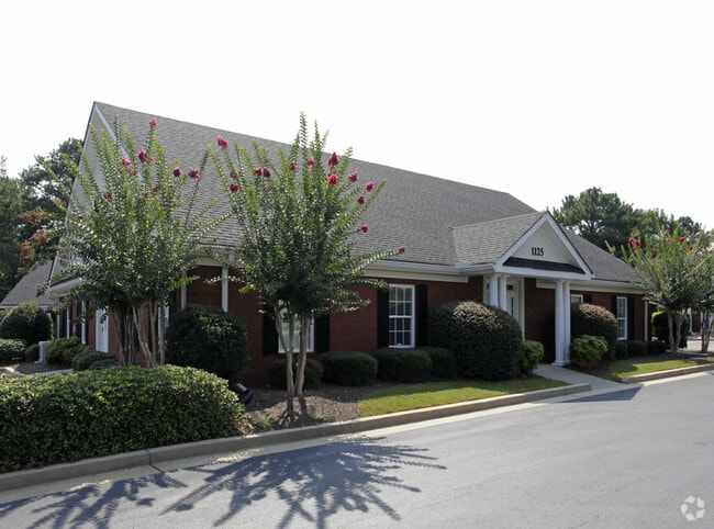
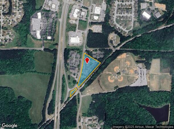
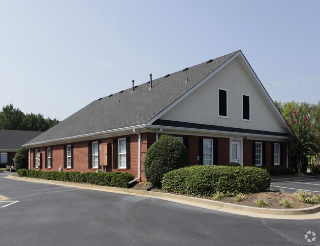
Property Record
1139 Senoia Rd, Tyrone, GA 30290
NEARBY LISTINGS FOR SALE OR LEASE
Property Detail
1139 Senoia Rd
Atlanta-Sandy Springs-Roswell, GA
North Village
07-27-00-054
LOT 1 NORTH VILLAGE
Officebuilding
Fayette
X
Georgia
13077C0180D
1
2024
3.48 AC
2024
Fayette/Coweta County
140204
Atlanta
18,109 SF
DEMOGRAPHICS near 1139 Senoia Rd
1 Mile
3 Mile
5 Mile
2024 Total Population
2,078
14,399
51,861
2029 Population
2,201
15,393
55,277
Pop Growth 2024-2029
+ 5.92%
+ 6.90%
+ 6.59%
Average Age
41
41
40
2024 Total Households
683
4,825
18,812
HH Growth 2024-2029
+ 6.15%
+ 6.98%
+ 6.48%
Median Household Inc
$92,176
$88,423
$90,259
Avg Household Size
3.00
3.00
2.70
2024 Avg HH Vehicles
3.00
2.00
2.00
Median Home Value
$350,465
$358,217
$353,677
Median Year Built
1997
1996
1998
Nearby Places
- Restaurants
- Banks
- Shops
- Fitness
- Groceries
PUBLIC TRANSPORTATION
AIRPORT
Hartsfield - Jackson Atlanta International
DRIVE
WALK
Distance
Hartsfield - Jackson Atlanta International
29 min
18.7 mi
SALE & LEASE HISTORY
LISTING DATE
SALE/LEASE

Oct 18, 2018
For Lease
Nearby Properties
Address
Land Use
TOTAL SIZE
Lot Size
Zoning
Address
Land Use
TOTAL SIZE
Lot Size
Zoning
412,253 SF
134.50 AC
Address
Land Use
TOTAL SIZE
Lot Size
Zoning
80,800 SF
9.39 AC
C C2
Address
Land Use
TOTAL SIZE
Lot Size
Zoning
603,938 SF
120.60 AC
Address
Land Use
TOTAL SIZE
Lot Size
Zoning
80,956 SF
60.90 AC
Address
Land Use
TOTAL SIZE
Lot Size
Zoning
72,376 SF
30.30 AC
Address
Land Use
TOTAL SIZE
Lot Size
Zoning
60.89 AC
I M1
Address
Land Use
TOTAL SIZE
Lot Size
Zoning
30,397 SF
24.50 AC
Address
Land Use
TOTAL SIZE
Lot Size
Zoning
12,859 SF
50.50 AC
Address
Land Use
TOTAL SIZE
Lot Size
Zoning
15,440 SF
10.86 AC
C C1
Address
Land Use
TOTAL SIZE
Lot Size
Zoning
11,780 SF
2.07 AC
C2
Address
Land Use
TOTAL SIZE
Lot Size
Zoning
17,248 SF
3.47 AC
C OI
Address
Land Use
TOTAL SIZE
Lot Size
Zoning
26,022 SF
3.48 AC
C C2
Address
Land Use
TOTAL SIZE
Lot Size
Zoning
24,100 SF
4.30 AC
C C3
Address
Land Use
TOTAL SIZE
Lot Size
Zoning
27,270 SF
3.28 AC
C C2
Address
Land Use
TOTAL SIZE
Lot Size
Zoning
720 SF
14.23 AC
AG1
Address
Land Use
TOTAL SIZE
Lot Size
Zoning
60,099 SF
3.60 AC
Address
Land Use
TOTAL SIZE
Lot Size
Zoning
24,033 SF
2.65 AC
C1
Address
Land Use
TOTAL SIZE
Lot Size
Zoning
14,375 SF
1.85 AC
C C1
Address
Land Use
TOTAL SIZE
Lot Size
Zoning
17,330 SF
4.16 AC
C OI
Address
Land Use
TOTAL SIZE
Lot Size
Zoning
3,794 SF
1.74 AC
C C2
Address
Land Use
TOTAL SIZE
Lot Size
Zoning
15,512 SF
11.26 AC
Address
Land Use
TOTAL SIZE
Lot Size
Zoning
14,426 SF
2.35 AC
C C1
Address
Land Use
TOTAL SIZE
Lot Size
Zoning
62,322 SF
25.50 AC
I M1
Address
Land Use
TOTAL SIZE
Lot Size
Zoning
21,063 SF
2.63 AC
C C1
Address
Land Use
TOTAL SIZE
Lot Size
Zoning
6,940 SF
1.65 AC
C C2
Address
Land Use
TOTAL SIZE
Lot Size
Zoning
9,670 SF
4.83 AC
C OI
Address
Land Use
TOTAL SIZE
Lot Size
Zoning
12,116 SF
1.47 AC
C OI
Address
Land Use
TOTAL SIZE
Lot Size
Zoning
10,855 SF
2.35 AC
C C2
Address
Land Use
TOTAL SIZE
Lot Size
Zoning
14,574 SF
6.65 AC
C OI
Address
Land Use
TOTAL SIZE
Lot Size
Zoning
5,807 SF
5.40 AC
C OI
The World's #1 Commercial Real Estate Marketplace
Connect with us
© 2025 CoStar Group
The information above has been obtained from sources believed reliable. While we do not doubt its accuracy we have not verified it and make no guarantee, warranty or representation about it. It is your responsibility to independently confirm its accuracy and completeness. Any projections, opinions, assumptions, or estimates used are for example only and do not represent the current or future performance of the property. The value of this transaction to you depends on tax and other factors which should be evaluated by your tax, financial, and legal advisors. You and your advisors should conduct a careful, independent investigation of the property to determine to your satisfaction the suitability of the property for your needs.