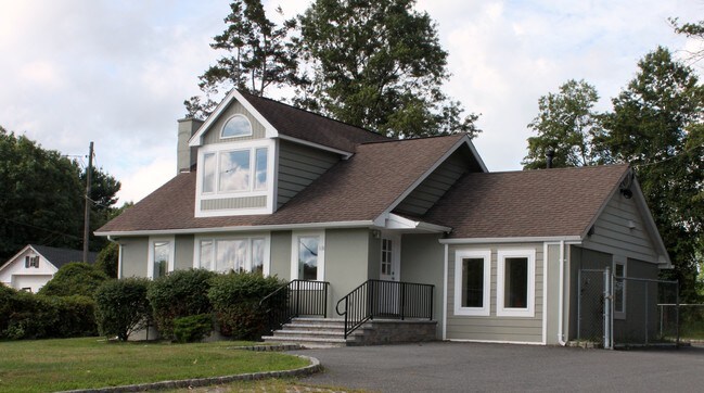
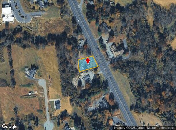
Property Record
1131 State Route 31, Lebanon, NJ 08833
NEARBY LISTINGS FOR SALE OR LEASE
Property Detail
1131 State Route 31
Newark, NJ-PA
New Jersey Department Of Transportation
06-00090-0000-00006
ADDITIONAL LOTS: 1485 RETAIL
Storebuilding
Hunterdon
X
New Jersey
34019C0253F
6
2024
0.45 AC
2025
Hunterdon
010802
Northern New Jersey
1,421 SF
DEMOGRAPHICS near 1131 State Route 31
1 Mile
3 Mile
5 Mile
2024 Total Population
1,552
9,233
31,604
2029 Population
1,567
9,332
32,098
Pop Growth 2024-2029
+ 0.97%
+ 1.07%
+ 1.56%
Average Age
42
44
44
2024 Total Households
514
3,358
11,685
HH Growth 2024-2029
+ 1.17%
+ 1.16%
+ 1.74%
Median Household Inc
$181,818
$166,709
$137,830
Avg Household Size
3.00
2.70
2.60
2024 Avg HH Vehicles
3.00
2.00
2.00
Median Home Value
$540,874
$565,758
$481,125
Median Year Built
1981
1982
1981
Nearby Places
Map Layers
Map Styles
 Street
 Aerial
- Restaurants
- Banks
- Shops
- Fitness
- Groceries
PUBLIC TRANSPORTATION
COMMUTER RAIL
Annandale (Raritan Valley Line - NJ Transit Commuter Rail (NJ Transit))
DRIVE
WALK
Distance
Annandale (Raritan Valley Line - NJ Transit Commuter Rail (NJ Transit))
10 min
6.0 mi
Lebanon (Raritan Valley Line - NJ Transit Commuter Rail (NJ Transit))
DRIVE
WALK
Distance
Lebanon (Raritan Valley Line - NJ Transit Commuter Rail (NJ Transit))
13 min
8.6 mi
AIRPORT
Trenton Mercer
DRIVE
WALK
Distance
Trenton Mercer
42 min
26.4 mi
Freight Ports
New York Container Terminal
DRIVE
WALK
Distance
New York Container Terminal
66 min
50.4 mi
SALE & LEASE HISTORY
LISTING DATE
SALE/LEASE

Sep 24, 2016
For Sale
Nearby Properties
Address
Land Use
TOTAL SIZE
Lot Size
Zoning
Address
Land Use
TOTAL SIZE
Lot Size
Zoning
84.62 AC
ROM1
Address
Land Use
TOTAL SIZE
Lot Size
Zoning
3,703.19 AC
RC
Address
Land Use
TOTAL SIZE
Lot Size
Zoning
49.26 AC
RR4S
Address
Land Use
TOTAL SIZE
Lot Size
Zoning
6 AC
ROM1
Address
Land Use
TOTAL SIZE
Lot Size
Zoning
9,408 SF
37 AC
ROM1
Address
Land Use
TOTAL SIZE
Lot Size
Zoning
10.20 AC
OB1
Address
Land Use
TOTAL SIZE
Lot Size
Zoning
244 SF
29.92 AC
RR4S
Address
Land Use
TOTAL SIZE
Lot Size
Zoning
10.44 AC
PUD
Address
Land Use
TOTAL SIZE
Lot Size
Zoning
2,087 SF
4.12 AC
ROM2
Address
Land Use
TOTAL SIZE
Lot Size
Zoning
6,618 SF
43.45 AC
RC
Address
Land Use
TOTAL SIZE
Lot Size
Zoning
5.80 AC
OB1
Address
Land Use
TOTAL SIZE
Lot Size
Zoning
98.91 AC
ROM1
Address
Land Use
TOTAL SIZE
Lot Size
Zoning
24.14 AC
AR-7
Address
Land Use
TOTAL SIZE
Lot Size
Zoning
28,430 SF
5 AC
AR
Address
Land Use
TOTAL SIZE
Lot Size
Zoning
15,876 SF
1.94 AC
ROM1
Address
Land Use
TOTAL SIZE
Lot Size
Zoning
22,358 SF
2.81 AC
C1
Address
Land Use
TOTAL SIZE
Lot Size
Zoning
3,683 SF
4.84 AC
C1
Address
Land Use
TOTAL SIZE
Lot Size
Zoning
8,148 SF
7.75 AC
R-1
Address
Land Use
TOTAL SIZE
Lot Size
Zoning
11,460 SF
2 AC
RR50
Address
Land Use
TOTAL SIZE
Lot Size
Zoning
7.11 AC
RR4S
Address
Land Use
TOTAL SIZE
Lot Size
Zoning
3.05 AC
C1
Address
Land Use
TOTAL SIZE
Lot Size
Zoning
2.77 AC
OB1
Address
Land Use
TOTAL SIZE
Lot Size
Zoning
10,352 SF
85.65 AC
RC
Address
Land Use
TOTAL SIZE
Lot Size
Zoning
2.69 AC
C1
Address
Land Use
TOTAL SIZE
Lot Size
Zoning
2,760 SF
90.55 AC
RC
Address
Land Use
TOTAL SIZE
Lot Size
Zoning
14,120 SF
2.20 AC
OB1
Address
Land Use
TOTAL SIZE
Lot Size
Zoning
44.20 AC
ROM1
Address
Land Use
TOTAL SIZE
Lot Size
Zoning
2,420 SF
68.70 AC
SRR
Address
Land Use
TOTAL SIZE
Lot Size
Zoning
8,106 SF
4 AC
RC
Address
Land Use
TOTAL SIZE
Lot Size
Zoning
0.39 AC
PUD
The World's #1 Commercial Real Estate Marketplace
Connect with us
© 2025 CoStar Group
The information above has been obtained from sources believed reliable. While we do not doubt its accuracy we have not verified it and make no guarantee, warranty or representation about it. It is your responsibility to independently confirm its accuracy and completeness. Any projections, opinions, assumptions, or estimates used are for example only and do not represent the current or future performance of the property. The value of this transaction to you depends on tax and other factors which should be evaluated by your tax, financial, and legal advisors. You and your advisors should conduct a careful, independent investigation of the property to determine to your satisfaction the suitability of the property for your needs.