Property Record
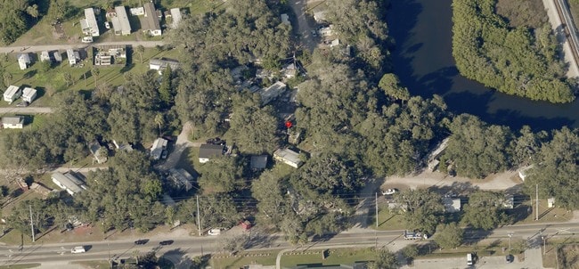
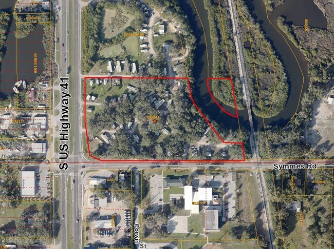
11310 S Us Highway 41 Hwy, Gibsonton, FL 33534
NEARBY LISTINGS FOR SALE OR LEASE
Property Detail
11310 S Us Highway 41 Hwy
Tampa-St. Petersburg-Clearwater, FL
Unplatted
U-26-30-19-ZZZ-000001-72640.0
THAT PART OF S 1120 FT OF SE 1/4 OF SW 1/4 LYING W OF SCL RR R/W LESS THE N 670 FT & LESS R/W FOR SR 45 TOGETHER WITH THE FOLLOWING THAT PART OF THE S 1120 FT OF SE 1/4 OF SW 1/4 LYING W OF SCL RR R/W LESS THE S 450 FT AND LESS R/W FOR SR 45 LESS THE
Campgroundrvpark
Hillsborough
AE
Florida
12057C0484J
72630
2024
7.71 AC
2024
Southeast Tampa
013804
Tampa/St Petersburg
1,776 SF
DEMOGRAPHICS near 11310 S Us Highway 41 Hwy
1 Mile
3 Mile
5 Mile
2024 Total Population
7,161
35,222
125,621
2029 Population
7,865
38,884
138,673
Pop Growth 2024-2029
+ 9.83%
+ 10.40%
+ 10.39%
Average Age
34
35
37
2024 Total Households
2,266
11,924
44,810
HH Growth 2024-2029
+ 10.06%
+ 10.63%
+ 10.62%
Median Household Inc
$77,055
$78,545
$81,074
Avg Household Size
3.10
2.90
2.80
2024 Avg HH Vehicles
2.00
2.00
2.00
Median Home Value
$242,905
$259,556
$276,015
Median Year Built
2001
2006
2006
Nearby Places
Map Layers
Map Styles
 Street
 Aerial
- Restaurants
- Banks
- Shops
- Fitness
- Groceries
PUBLIC TRANSPORTATION
AIRPORT
Tampa International
DRIVE
WALK
Distance
Tampa International
33 min
20.6 mi
St Pete-Clearwater International
DRIVE
WALK
Distance
St Pete-Clearwater International
50 min
29.8 mi
Freight Ports
Port of Tampa Bay
DRIVE
WALK
Distance
Port of Tampa Bay
17 min
9.9 mi
Nearby Properties
Address
Land Use
TOTAL SIZE
Lot Size
Zoning
Address
Land Use
TOTAL SIZE
Lot Size
Zoning
399,150 SF
26.32 AC
PD
Address
Land Use
TOTAL SIZE
Lot Size
Zoning
370,924 SF
73.35 AC
PD
Address
Land Use
TOTAL SIZE
Lot Size
Zoning
628,730 SF
952.72 AC
M
Address
Land Use
TOTAL SIZE
Lot Size
Zoning
347,147 SF
258.94 AC
PD
Address
Land Use
TOTAL SIZE
Lot Size
Zoning
425,231 SF
23.78 AC
M
Address
Land Use
TOTAL SIZE
Lot Size
Zoning
124,865 SF
20.14 AC
PD
Address
Land Use
TOTAL SIZE
Lot Size
Zoning
146,440 SF
18.56 AC
PD
Address
Land Use
TOTAL SIZE
Lot Size
Zoning
48,968 SF
10 AC
PD
Address
Land Use
TOTAL SIZE
Lot Size
Zoning
520,366 SF
122.24 AC
PD
Address
Land Use
TOTAL SIZE
Lot Size
Zoning
178,496 SF
17.63 AC
PD
Address
Land Use
TOTAL SIZE
Lot Size
Zoning
215,929 SF
26.74 AC
PD
Address
Land Use
TOTAL SIZE
Lot Size
Zoning
88,445 SF
14.41 AC
PD
Address
Land Use
TOTAL SIZE
Lot Size
Zoning
110,148 SF
23.04 AC
M
Address
Land Use
TOTAL SIZE
Lot Size
Zoning
924 SF
563.45 AC
AR
Address
Land Use
TOTAL SIZE
Lot Size
Zoning
40,676 SF
8.56 AC
M
Address
Land Use
TOTAL SIZE
Lot Size
Zoning
101,880 SF
6.53 AC
PD
Address
Land Use
TOTAL SIZE
Lot Size
Zoning
35,795 SF
48.06 AC
AI
Address
Land Use
TOTAL SIZE
Lot Size
Zoning
72,298 SF
9.58 AC
PD
Address
Land Use
TOTAL SIZE
Lot Size
Zoning
122.18 AC
PD
Address
Land Use
TOTAL SIZE
Lot Size
Zoning
87,068 SF
24.86 AC
PD
Address
Land Use
TOTAL SIZE
Lot Size
Zoning
54,892 SF
2.57 AC
PD
Address
Land Use
TOTAL SIZE
Lot Size
Zoning
327.61 AC
AR
Address
Land Use
TOTAL SIZE
Lot Size
Zoning
83,235 SF
21.40 AC
M
Address
Land Use
TOTAL SIZE
Lot Size
Zoning
290.36 AC
AI
Address
Land Use
TOTAL SIZE
Lot Size
Zoning
0.37 AC
PD
Address
Land Use
TOTAL SIZE
Lot Size
Zoning
21,780 SF
2.39 AC
PD
Address
Land Use
TOTAL SIZE
Lot Size
Zoning
83,301 SF
9.99 AC
PD
Address
Land Use
TOTAL SIZE
Lot Size
Zoning
79.33 AC
RMC-6
Address
Land Use
TOTAL SIZE
Lot Size
Zoning
94,078 SF
10.68 AC
AR
Address
Land Use
TOTAL SIZE
Lot Size
Zoning
30,064 SF
58.41 AC
M
The World's #1 Commercial Real Estate Marketplace
Connect with us
© 2025 CoStar Group
The information above has been obtained from sources believed reliable. While we do not doubt its accuracy we have not verified it and make no guarantee, warranty or representation about it. It is your responsibility to independently confirm its accuracy and completeness. Any projections, opinions, assumptions, or estimates used are for example only and do not represent the current or future performance of the property. The value of this transaction to you depends on tax and other factors which should be evaluated by your tax, financial, and legal advisors. You and your advisors should conduct a careful, independent investigation of the property to determine to your satisfaction the suitability of the property for your needs.