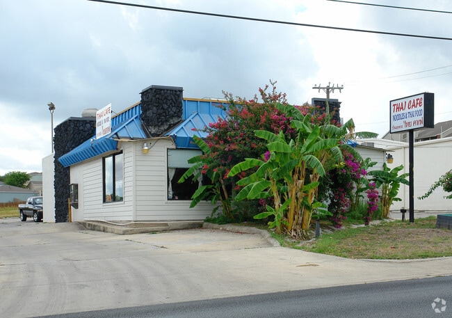
Property Record
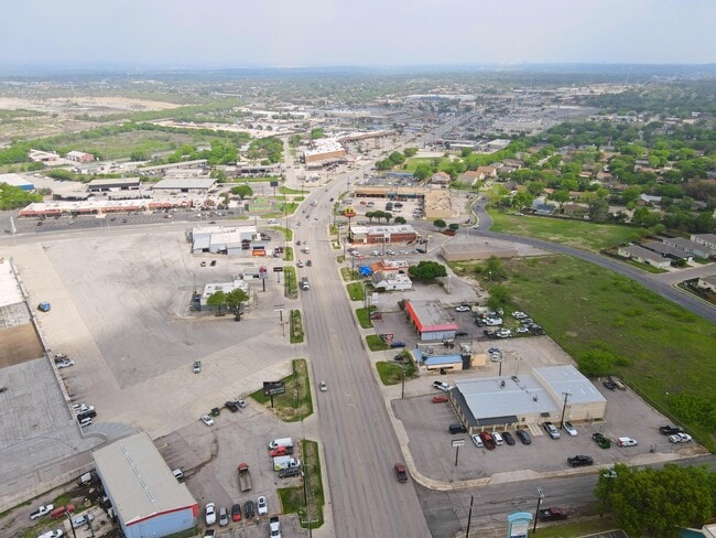
11318 Perrin Beitel Rd, San Antonio, TX 78217

NEARBY LISTINGS FOR SALE OR LEASE
Property Detail
11318 Perrin Beitel Rd
San Antonio-New Braunfels, TX
Conv A/S Code
16498-001-0050
NCB 16498 BLK 1 LOT 5
Restaurantbuilding
Bexar
X
Texas
48029C0270G
5
2024
0.46 AC
2025
Northeast
121205
San Antonio
2,380 SF
DEMOGRAPHICS near 11318 Perrin Beitel Rd
1 Mile
3 Mile
5 Mile
2024 Total Population
9,107
95,079
268,698
2029 Population
9,610
100,496
284,833
Pop Growth 2024-2029
+ 5.52%
+ 5.70%
+ 6.00%
Average Age
37
39
39
2024 Total Households
4,038
38,924
106,483
HH Growth 2024-2029
+ 5.67%
+ 5.90%
+ 6.18%
Median Household Inc
$42,923
$56,652
$63,732
Avg Household Size
2.20
2.40
2.40
2024 Avg HH Vehicles
2.00
2.00
2.00
Median Home Value
$151,839
$187,288
$214,282
Median Year Built
1978
1980
1983
Nearby Places
Map Layers
Map Styles
 Street
 Aerial
- Restaurants
- Banks
- Shops
- Fitness
- Groceries
PUBLIC TRANSPORTATION
AIRPORT
San Antonio International
DRIVE
WALK
Distance
San Antonio International
10 min
6.2 mi
Freight Ports
Calhoun Port
DRIVE
WALK
Distance
Calhoun Port
185 min
152.0 mi
SALE & LEASE HISTORY
LISTING DATE
SALE/LEASE

Apr 17, 2025
For Sale
Nearby Properties
Address
Land Use
TOTAL SIZE
Lot Size
Zoning
Address
Land Use
TOTAL SIZE
Lot Size
Zoning
25,513 SF
18.14 AC
Address
Land Use
TOTAL SIZE
Lot Size
Zoning
359,349 SF
23.59 AC
Address
Land Use
TOTAL SIZE
Lot Size
Zoning
239,264 SF
9.02 AC
Address
Land Use
TOTAL SIZE
Lot Size
Zoning
266,702 SF
13.49 AC
Address
Land Use
TOTAL SIZE
Lot Size
Zoning
288,350 SF
13.01 AC
Address
Land Use
TOTAL SIZE
Lot Size
Zoning
46,674 SF
53.43 AC
Address
Land Use
TOTAL SIZE
Lot Size
Zoning
279,012 SF
12.17 AC
Address
Land Use
TOTAL SIZE
Lot Size
Zoning
180,000 SF
40.73 AC
Address
Land Use
TOTAL SIZE
Lot Size
Zoning
92,859 SF
11.95 AC
Address
Land Use
TOTAL SIZE
Lot Size
Zoning
265,015 SF
12.81 AC
Address
Land Use
TOTAL SIZE
Lot Size
Zoning
205,862 SF
10.79 AC
Address
Land Use
TOTAL SIZE
Lot Size
Zoning
275,327 SF
13.52 AC
Address
Land Use
TOTAL SIZE
Lot Size
Zoning
373,134 SF
16.29 AC
Address
Land Use
TOTAL SIZE
Lot Size
Zoning
106,139 SF
5.84 AC
Address
Land Use
TOTAL SIZE
Lot Size
Zoning
263,209 SF
13.67 AC
Address
Land Use
TOTAL SIZE
Lot Size
Zoning
257,263 SF
10.07 AC
Address
Land Use
TOTAL SIZE
Lot Size
Zoning
276,202 SF
17.32 AC
Address
Land Use
TOTAL SIZE
Lot Size
Zoning
257,734 SF
5.57 AC
Address
Land Use
TOTAL SIZE
Lot Size
Zoning
324,905 SF
22.32 AC
Address
Land Use
TOTAL SIZE
Lot Size
Zoning
212,078 SF
9.83 AC
Address
Land Use
TOTAL SIZE
Lot Size
Zoning
213,566 SF
10.17 AC
Address
Land Use
TOTAL SIZE
Lot Size
Zoning
241,922 SF
18.20 AC
Address
Land Use
TOTAL SIZE
Lot Size
Zoning
261,471 SF
11 AC
Address
Land Use
TOTAL SIZE
Lot Size
Zoning
312,516 SF
15.61 AC
Address
Land Use
TOTAL SIZE
Lot Size
Zoning
325,697 SF
18.17 AC
Address
Land Use
TOTAL SIZE
Lot Size
Zoning
228,927 SF
16.25 AC
Address
Land Use
TOTAL SIZE
Lot Size
Zoning
191,072 SF
9.78 AC
Address
Land Use
TOTAL SIZE
Lot Size
Zoning
190,357 SF
18.08 AC
Address
Land Use
TOTAL SIZE
Lot Size
Zoning
131,653 SF
10.94 AC
Address
Land Use
TOTAL SIZE
Lot Size
Zoning
57,443 SF
4.70 AC
The World's #1 Commercial Real Estate Marketplace
Connect with us
© 2025 CoStar Group
The information above has been obtained from sources believed reliable. While we do not doubt its accuracy we have not verified it and make no guarantee, warranty or representation about it. It is your responsibility to independently confirm its accuracy and completeness. Any projections, opinions, assumptions, or estimates used are for example only and do not represent the current or future performance of the property. The value of this transaction to you depends on tax and other factors which should be evaluated by your tax, financial, and legal advisors. You and your advisors should conduct a careful, independent investigation of the property to determine to your satisfaction the suitability of the property for your needs.