Property Record
1132 E Cutlar Crossing Xing, Leland, NC 28451
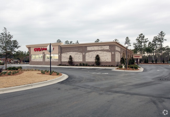


Property Detail
1132 E Cutlar Crossing Xing
0580000712
L-7 1.52 ACRES EAST VILLAGE PL 42/94 US 17
Drugstorepharmacycvswalgreens
Brunswick
C2
North Carolina
B and X Area of moderate flood hazard, usually the area between the limits of the 100-year and 500-year floods.
7
2025
1.52 AC
2025
Leland
020205
Wilmington
11,822 SF
Wilmington, NC
NEARBY LISTINGS FOR SALE OR LEASE
-
-
View all Leland listings for sale on LoopNet.com
DEMOGRAPHICS near 1132 E Cutlar Crossing Xing
1 mile
3 mile
5 mile
2025 Total Population
1,546
23,464
36,663
2030 Population
1,781
27,126
42,336
Pop Growth 2025-2030
+ 15.20%
+ 15.61%
+ 15.47%
Average Age
51
47
45
2025 Total Households
668
10,101
15,325
HH Growth 2025-2030
+ 14.97%
+ 15.39%
+ 15.30%
Median Household Inc
$97,115
$89,592
$84,443
Avg Household Size
2.20
2.30
2.30
2025 Avg HH Vehicles
2.00
2.00
2.00
Median Home Value
$410,494
$382,962
$360,680
Median Year Built
2010
2009
2009
Nearby Places
Map Layers
Map Styles
 Street
 Aerial
Layers
 Traffic
 Biking
Places
Listings with unknown addresses are not visible on the map
- Restaurants
- Banks
- Shops
- Fitness
- Groceries
PUBLIC TRANSPORTATION
AIRPORT
Wilmington International
Drive
Walk
Distance
Wilmington International
27 min
13.4 mi
Freight Ports
Port of Wilmington
Drive
Walk
Distance
Port of Wilmington
17 min
9.1 mi
Nearby Properties
Address
Land Use
TOTAL SIZE
Lot Size
Zoning
Address
Land Use
TOTAL SIZE
Lot Size
Zoning
31,272 SF
23.52 AC
PUD
Address
Land Use
TOTAL SIZE
Lot Size
Zoning
1,495 SF
22.50 AC
MF
Address
Land Use
TOTAL SIZE
Lot Size
Zoning
6,839 SF
28.63 AC
MF
Address
Land Use
TOTAL SIZE
Lot Size
Zoning
25,392 SF
15.91 AC
MF
Address
Land Use
TOTAL SIZE
Lot Size
Zoning
50,441 SF
19.08 AC
MF
Address
Land Use
TOTAL SIZE
Lot Size
Zoning
23,868 SF
15.20 AC
CLD
Address
Land Use
TOTAL SIZE
Lot Size
Zoning
206,487 SF
10.68 AC
MF
Address
Land Use
TOTAL SIZE
Lot Size
Zoning
16,152 SF
25.44 AC
MF
Address
Land Use
TOTAL SIZE
Lot Size
Zoning
170,188 SF
59.74 AC
OI
Address
Land Use
TOTAL SIZE
Lot Size
Zoning
448.80 AC
MF
Address
Land Use
TOTAL SIZE
Lot Size
Zoning
10,122 SF
8.46 AC
MF
Address
Land Use
TOTAL SIZE
Lot Size
Zoning
22,785 SF
10.19 AC
I
Address
Land Use
TOTAL SIZE
Lot Size
Zoning
81,572 SF
5.53 AC
MF
Address
Land Use
TOTAL SIZE
Lot Size
Zoning
178,677 SF
23.66 AC
C2
Address
Land Use
TOTAL SIZE
Lot Size
Zoning
48,662 SF
11.45 AC
C2
Address
Land Use
TOTAL SIZE
Lot Size
Zoning
106,450 SF
36.50 AC
OI
Address
Land Use
TOTAL SIZE
Lot Size
Zoning
54,900 SF
3.55 AC
C2
Address
Land Use
TOTAL SIZE
Lot Size
Zoning
Address
Land Use
TOTAL SIZE
Lot Size
Zoning
43,792 SF
2.58 AC
C2
Address
Land Use
TOTAL SIZE
Lot Size
Zoning
56,482 SF
1.68 AC
C2
Address
Land Use
TOTAL SIZE
Lot Size
Zoning
4,525 SF
792.28 AC
PUD
Address
Land Use
TOTAL SIZE
Lot Size
Zoning
22,344 SF
4 AC
I
Address
Land Use
TOTAL SIZE
Lot Size
Zoning
113,225 SF
12.28 AC
C2
Address
Land Use
TOTAL SIZE
Lot Size
Zoning
1,652 SF
20.64 AC
CLD
Address
Land Use
TOTAL SIZE
Lot Size
Zoning
4,980 SF
9.19 AC
IG
Address
Land Use
TOTAL SIZE
Lot Size
Zoning
43,960 SF
2.62 AC
C2
Address
Land Use
TOTAL SIZE
Lot Size
Zoning
45,053 SF
2.90 AC
C2
Address
Land Use
TOTAL SIZE
Lot Size
Zoning
50,342 SF
4.90 AC
C2
Address
Land Use
TOTAL SIZE
Lot Size
Zoning
34,070 SF
11.09 AC
C2
Address
Land Use
TOTAL SIZE
Lot Size
Zoning
57,088 SF
3.26 AC
PUD
The World's #1 Commercial Real Estate Marketplace
Connect with us
© 2026 CoStar Group
The information above has been obtained from sources believed reliable. While we do not doubt its accuracy we have not verified it and make no guarantee, warranty or representation about it. It is your responsibility to independently confirm its accuracy and completeness. Any projections, opinions, assumptions, or estimates used are for example only and do not represent the current or future performance of the property. The value of this transaction to you depends on tax and other factors which should be evaluated by your tax, financial, and legal advisors. You and your advisors should conduct a careful, independent investigation of the property to determine to your satisfaction the suitability of the property for your needs.