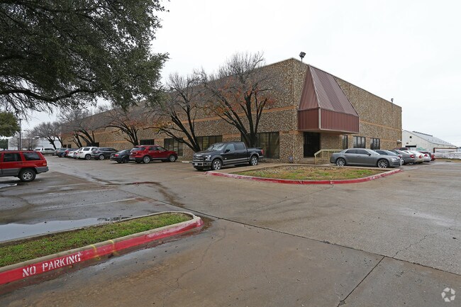
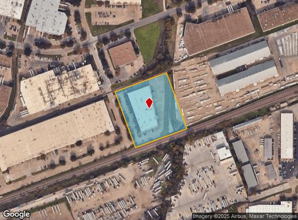
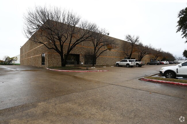
Property Record
11330 Hillguard Rd, Dallas, TX 75243
NEARBY LISTINGS FOR SALE OR LEASE
Property Detail
11330 Hillguard Rd
00000787119060000
Northgate Business Park #1
Warehouse
NORTHGATE BUSINESS PARK #1 BLK B/8071 335FR CHARTWELL HILLGUARD & DILWORRTH VOL96184/4988 DD091996 CO-DALLAS 8071 00B 000 3008071 00B
X
Dallas
48113C0215K
Texas
2024
3.40 AC
2025
NE Dallas/Garland
018506
Dallas/Ft Worth
37,075 SF
Dallas-Fort Worth-Arlington, TX
DEMOGRAPHICS near 11330 Hillguard Rd
1 Mile
3 Mile
5 Mile
2024 Total Population
15,776
154,189
412,506
2029 Population
15,637
152,973
409,195
Pop Growth 2024-2029
(0.88%)
(0.79%)
(0.80%)
Average Age
33
36
37
2024 Total Households
6,476
59,521
161,755
HH Growth 2024-2029
(0.90%)
(0.89%)
(0.85%)
Median Household Inc
$41,256
$53,885
$58,420
Avg Household Size
2.40
2.50
2.50
2024 Avg HH Vehicles
1.00
2.00
2.00
Median Home Value
$271,186
$324,494
$278,317
Median Year Built
1981
1978
1976
Nearby Places
Map Layers
Map Styles
 Street
 Aerial
- Restaurants
- Banks
- Shops
- Fitness
- Groceries
PUBLIC TRANSPORTATION
AIRPORT
Dallas Love Field
DRIVE
WALK
Distance
Dallas Love Field
28 min
17.2 mi
Dallas-Fort Worth International
DRIVE
WALK
Distance
Dallas-Fort Worth International
35 min
26.0 mi
Nearby Properties
Address
Land Use
TOTAL SIZE
Lot Size
Zoning
Address
Land Use
TOTAL SIZE
Lot Size
Zoning
1,252,860 SF
57.08 AC
Z239
Address
Land Use
TOTAL SIZE
Lot Size
Zoning
428,956 SF
18.76 AC
Z291
Address
Land Use
TOTAL SIZE
Lot Size
Zoning
249,692 SF
244.62 AC
Z239
Address
Land Use
TOTAL SIZE
Lot Size
Zoning
306,323 SF
10.99 AC
Z164
Address
Land Use
TOTAL SIZE
Lot Size
Zoning
316,085 SF
13.73 AC
Z107
Address
Land Use
TOTAL SIZE
Lot Size
Zoning
347,933 SF
12.61 AC
Z164
Address
Land Use
TOTAL SIZE
Lot Size
Zoning
181,854 SF
14.51 AC
Z239
Address
Land Use
TOTAL SIZE
Lot Size
Zoning
403,415 SF
3.43 AC
Z163
Address
Land Use
TOTAL SIZE
Lot Size
Zoning
1,099,201 SF
107.82 AC
Z116
Address
Land Use
TOTAL SIZE
Lot Size
Zoning
319,969 SF
16.54 AC
Z163
Address
Land Use
TOTAL SIZE
Lot Size
Zoning
310,119 SF
9.65 AC
Z150
Address
Land Use
TOTAL SIZE
Lot Size
Zoning
391,774 SF
3.97 AC
Z239
Address
Land Use
TOTAL SIZE
Lot Size
Zoning
291,579 SF
13.79 AC
Z151
Address
Land Use
TOTAL SIZE
Lot Size
Zoning
144,728 SF
46.87 AC
Z239
Address
Land Use
TOTAL SIZE
Lot Size
Zoning
517,500 SF
29.97 AC
Z116
Address
Land Use
TOTAL SIZE
Lot Size
Zoning
922,851 SF
52.30 AC
Z144
Address
Land Use
TOTAL SIZE
Lot Size
Zoning
334,910 SF
14.26 AC
Z151
Address
Land Use
TOTAL SIZE
Lot Size
Zoning
431,982 SF
19.32 AC
Z164
Address
Land Use
TOTAL SIZE
Lot Size
Zoning
277,296 SF
13.54 AC
Z207
Address
Land Use
TOTAL SIZE
Lot Size
Zoning
211,913 SF
6.76 AC
Z151
Address
Land Use
TOTAL SIZE
Lot Size
Zoning
472,244 SF
25.25 AC
Z144
Address
Land Use
TOTAL SIZE
Lot Size
Zoning
275,557 SF
13.64 AC
Z291
Address
Land Use
TOTAL SIZE
Lot Size
Zoning
292,827 SF
13.81 AC
Z163
Address
Land Use
TOTAL SIZE
Lot Size
Zoning
531,950 SF
24.62 AC
Z239
Address
Land Use
TOTAL SIZE
Lot Size
Zoning
347,718 SF
18.61 AC
Z163
Address
Land Use
TOTAL SIZE
Lot Size
Zoning
922,851 SF
52.28 AC
Z144
Address
Land Use
TOTAL SIZE
Lot Size
Zoning
121,440 SF
17.02 AC
Z298
Address
Land Use
TOTAL SIZE
Lot Size
Zoning
227,584 SF
12.03 AC
Z165
Address
Land Use
TOTAL SIZE
Lot Size
Zoning
333,298 SF
10.91 AC
Z149
Address
Land Use
TOTAL SIZE
Lot Size
Zoning
265,986 SF
13.75 AC
Z163
The World's #1 Commercial Real Estate Marketplace
Connect with us
© 2025 CoStar Group
The information above has been obtained from sources believed reliable. While we do not doubt its accuracy we have not verified it and make no guarantee, warranty or representation about it. It is your responsibility to independently confirm its accuracy and completeness. Any projections, opinions, assumptions, or estimates used are for example only and do not represent the current or future performance of the property. The value of this transaction to you depends on tax and other factors which should be evaluated by your tax, financial, and legal advisors. You and your advisors should conduct a careful, independent investigation of the property to determine to your satisfaction the suitability of the property for your needs.