Property Record
11331 Interstate 10 E, Baytown, TX 77523
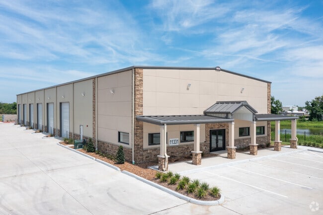

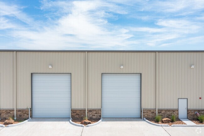
Property Detail
11331 Interstate 10 E
00321-04200-00100-090100
321 TR 42-1-1 C C SCHOOL CAGI CARRIES IMPS - ACCT 8555
Industrialgeneral
Chambers
B and X Area of moderate flood hazard, usually the area between the limits of the 100-year and 500-year floods.
Texas
2025
13.40 AC
2025
East-Southeast Far
710100
Houston
5,000 SF
Houston-Pasadena-The Woodlands, TX
NEARBY LISTINGS FOR SALE OR LEASE
DEMOGRAPHICS near 11331 Interstate 10 E
1 mile
3 mile
5 mile
2024 Total Population
809
21,221
46,067
2029 Population
1,041
26,978
57,068
Pop Growth 2024-2029
+ 28.68%
+ 27.13%
+ 23.88%
Average Age
35
34
36
2024 Total Households
260
6,764
14,927
HH Growth 2024-2029
+ 28.85%
+ 27.19%
+ 23.79%
Median Household Inc
$127,717
$117,770
$103,048
Avg Household Size
3.10
3.10
3.10
2024 Avg HH Vehicles
2.00
2.00
2.00
Median Home Value
$330,769
$265,173
$284,624
Median Year Built
2010
2010
2007
Nearby Places
Map Layers
Map Styles
 Street
 Aerial
Transit
 Traffic
 Biking
Places
Listings with unknown addresses are not visible on the map
- Restaurants
- Banks
- Shops
- Fitness
- Groceries
PUBLIC TRANSPORTATION
AIRPORT
William P Hobby
Drive
Walk
Distance
William P Hobby
51 min
35.5 mi
George Bush Intcntl/Houston
Drive
Walk
Distance
George Bush Intcntl/Houston
48 min
39.7 mi
Freight Ports
Port of Houston
Drive
Walk
Distance
Port of Houston
38 min
27.5 mi
SALE & LEASE HISTORY
LISTING DATE
SALE/LEASE

Jan 08, 2021
For Lease
Nearby Properties
Address
Land Use
TOTAL SIZE
Lot Size
Zoning
Address
Land Use
TOTAL SIZE
Lot Size
Zoning
0.58 AC
Address
Land Use
TOTAL SIZE
Lot Size
Zoning
63,224 SF
738.31 AC
Address
Land Use
TOTAL SIZE
Lot Size
Zoning
738.47 AC
Address
Land Use
TOTAL SIZE
Lot Size
Zoning
463.62 AC
Address
Land Use
TOTAL SIZE
Lot Size
Zoning
738.31 AC
Address
Land Use
TOTAL SIZE
Lot Size
Zoning
Address
Land Use
TOTAL SIZE
Lot Size
Zoning
Address
Land Use
TOTAL SIZE
Lot Size
Zoning
738.47 AC
Address
Land Use
TOTAL SIZE
Lot Size
Zoning
504,680 SF
29.61 AC
Address
Land Use
TOTAL SIZE
Lot Size
Zoning
194,400 SF
53.79 AC
Address
Land Use
TOTAL SIZE
Lot Size
Zoning
133,873 SF
12.26 AC
Address
Land Use
TOTAL SIZE
Lot Size
Zoning
22,375 SF
12.13 AC
Address
Land Use
TOTAL SIZE
Lot Size
Zoning
58,493 SF
18.49 AC
Address
Land Use
TOTAL SIZE
Lot Size
Zoning
738.47 AC
Address
Land Use
TOTAL SIZE
Lot Size
Zoning
11,189 SF
7.40 AC
Address
Land Use
TOTAL SIZE
Lot Size
Zoning
3,900 SF
42.94 AC
Address
Land Use
TOTAL SIZE
Lot Size
Zoning
13,927 SF
23.39 AC
Address
Land Use
TOTAL SIZE
Lot Size
Zoning
9,087 SF
6.98 AC
Address
Land Use
TOTAL SIZE
Lot Size
Zoning
222,375 SF
42.92 AC
Address
Land Use
TOTAL SIZE
Lot Size
Zoning
34,504 SF
9.19 AC
Address
Land Use
TOTAL SIZE
Lot Size
Zoning
42.79 AC
Address
Land Use
TOTAL SIZE
Lot Size
Zoning
187,383 SF
18.95 AC
Address
Land Use
TOTAL SIZE
Lot Size
Zoning
9,627 SF
6.91 AC
Address
Land Use
TOTAL SIZE
Lot Size
Zoning
2,239 SF
9.15 AC
Address
Land Use
TOTAL SIZE
Lot Size
Zoning
46.88 AC
Address
Land Use
TOTAL SIZE
Lot Size
Zoning
21,000 SF
51.28 AC
Address
Land Use
TOTAL SIZE
Lot Size
Zoning
68.73 AC
Address
Land Use
TOTAL SIZE
Lot Size
Zoning
24.90 AC
Address
Land Use
TOTAL SIZE
Lot Size
Zoning
34.88 AC
The World's #1 Commercial Real Estate Marketplace
Connect with us
© 2026 CoStar Group
The information above has been obtained from sources believed reliable. While we do not doubt its accuracy we have not verified it and make no guarantee, warranty or representation about it. It is your responsibility to independently confirm its accuracy and completeness. Any projections, opinions, assumptions, or estimates used are for example only and do not represent the current or future performance of the property. The value of this transaction to you depends on tax and other factors which should be evaluated by your tax, financial, and legal advisors. You and your advisors should conduct a careful, independent investigation of the property to determine to your satisfaction the suitability of the property for your needs.