Property Record
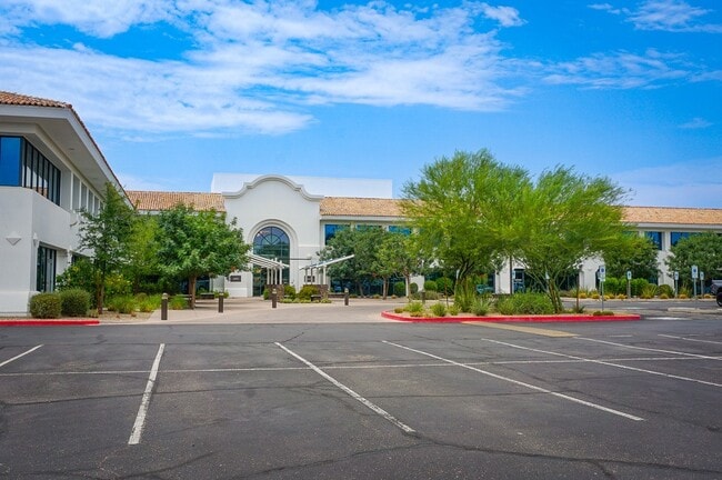
11333 N Scottsdale Rd, Scottsdale, AZ 85254


Current Lease Availabilities
NEARBY LISTINGS FOR SALE OR LEASE
Property Detail
11333 N Scottsdale Rd
Phoenix-Mesa-Chandler, AZ
Corvalian Estates #1
175-34-002L
PT SW4 SEEC 23 DAF BEG W4 COR SD SEC TH E 530.01F TO NW COR CORVALIAN ESTATES NO. 1 MCR 112-46 TH S 662.64F TH W 205F N 200F W 325F N 462.80F TO POB EX RD P/F 9008/837 & EX RD P/F 96-600688
Officebuilding
Maricopa
X
Arizona
04013C1760L
89
2025
5.46 AC
2025
Central Scottsdale
216831
Phoenix
81,816 SF
DEMOGRAPHICS near 11333 N Scottsdale Rd
1 Mile
3 Mile
5 Mile
2024 Total Population
7,737
69,942
204,066
2029 Population
8,410
76,747
223,187
Pop Growth 2024-2029
+ 8.70%
+ 9.73%
+ 9.37%
Average Age
45
46
44
2024 Total Households
3,519
31,100
91,937
HH Growth 2024-2029
+ 8.78%
+ 10.10%
+ 9.66%
Median Household Inc
$96,104
$116,414
$104,397
Avg Household Size
2.10
2.20
2.20
2024 Avg HH Vehicles
2.00
2.00
2.00
Median Home Value
$780,874
$728,472
$660,130
Median Year Built
1984
1986
1987
Nearby Places
Map Layers
Map Styles
 Street
 Aerial
- Restaurants
- Banks
- Shops
- Fitness
- Groceries
PUBLIC TRANSPORTATION
AIRPORT
Phoenix Sky Harbor International
DRIVE
WALK
Distance
Phoenix Sky Harbor International
29 min
15.2 mi
Phoenix-Mesa Gateway
DRIVE
WALK
Distance
Phoenix-Mesa Gateway
50 min
35.4 mi
Nearby Properties
Address
Land Use
TOTAL SIZE
Lot Size
Zoning
Address
Land Use
TOTAL SIZE
Lot Size
Zoning
1,293,284 SF
14.50 AC
C-R
Address
Land Use
TOTAL SIZE
Lot Size
Zoning
3.15 AC
I-P
Address
Land Use
TOTAL SIZE
Lot Size
Zoning
33,244 SF
5.93 AC
C-2
Address
Land Use
TOTAL SIZE
Lot Size
Zoning
667,688 SF
277.21 AC
Address
Land Use
TOTAL SIZE
Lot Size
Zoning
500,010 SF
4.52 AC
PF
Address
Land Use
TOTAL SIZE
Lot Size
Zoning
4.67 AC
Address
Land Use
TOTAL SIZE
Lot Size
Zoning
367,367 SF
37.89 AC
R-43
Address
Land Use
TOTAL SIZE
Lot Size
Zoning
623,263 SF
27.34 AC
M-H
Address
Land Use
TOTAL SIZE
Lot Size
Zoning
7,803 SF
2.31 AC
I-P
Address
Land Use
TOTAL SIZE
Lot Size
Zoning
533,288 SF
18.61 AC
I-P
Address
Land Use
TOTAL SIZE
Lot Size
Zoning
428,891 SF
6.48 AC
PAD
Address
Land Use
TOTAL SIZE
Lot Size
Zoning
824,672 SF
11.52 AC
Address
Land Use
TOTAL SIZE
Lot Size
Zoning
380,106 SF
38.10 AC
C-T
Address
Land Use
TOTAL SIZE
Lot Size
Zoning
9,232 SF
4.07 AC
R-35
Address
Land Use
TOTAL SIZE
Lot Size
Zoning
355,757 SF
32.44 AC
C-R
Address
Land Use
TOTAL SIZE
Lot Size
Zoning
337,668 SF
8.14 AC
PAD
Address
Land Use
TOTAL SIZE
Lot Size
Zoning
734,506 SF
7.75 AC
C-T
Address
Land Use
TOTAL SIZE
Lot Size
Zoning
417,831 SF
2.68 AC
C-R
Address
Land Use
TOTAL SIZE
Lot Size
Zoning
542,795 SF
5.56 AC
PCP
Address
Land Use
TOTAL SIZE
Lot Size
Zoning
494,970 SF
4.90 AC
PUD
Address
Land Use
TOTAL SIZE
Lot Size
Zoning
515,127 SF
7.57 AC
C-T
Address
Land Use
TOTAL SIZE
Lot Size
Zoning
250,415 SF
21 AC
I-P
Address
Land Use
TOTAL SIZE
Lot Size
Zoning
Address
Land Use
TOTAL SIZE
Lot Size
Zoning
423,600 SF
5.13 AC
I1
Address
Land Use
TOTAL SIZE
Lot Size
Zoning
575,367 SF
3.77 AC
Address
Land Use
TOTAL SIZE
Lot Size
Zoning
163,075 SF
17.77 AC
C-R
Address
Land Use
TOTAL SIZE
Lot Size
Zoning
353,691 SF
16.18 AC
M-H
Address
Land Use
TOTAL SIZE
Lot Size
Zoning
166,962 SF
52.81 AC
Address
Land Use
TOTAL SIZE
Lot Size
Zoning
388,480 SF
18.69 AC
PAD
Address
Land Use
TOTAL SIZE
Lot Size
Zoning
345,713 SF
18.25 AC
M-H
The World's #1 Commercial Real Estate Marketplace
Connect with us
© 2026 CoStar Group
The information above has been obtained from sources believed reliable. While we do not doubt its accuracy we have not verified it and make no guarantee, warranty or representation about it. It is your responsibility to independently confirm its accuracy and completeness. Any projections, opinions, assumptions, or estimates used are for example only and do not represent the current or future performance of the property. The value of this transaction to you depends on tax and other factors which should be evaluated by your tax, financial, and legal advisors. You and your advisors should conduct a careful, independent investigation of the property to determine to your satisfaction the suitability of the property for your needs.