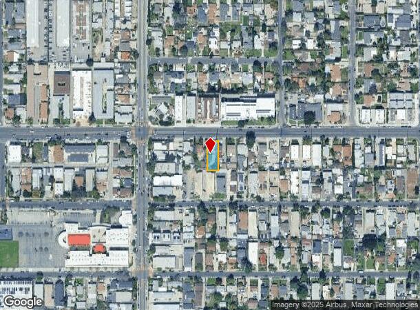
Property Record
11334 Oxnard St, North Hollywood, CA 91606
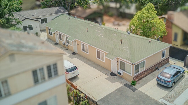
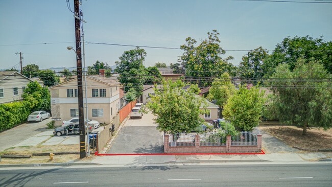
This Property Is For Sale
NEARBY LISTINGS FOR SALE OR LEASE
Property Detail
11334 Oxnard St
Los Angeles-Long Beach-Glendale, CA
5881
2337-010-008
Los Angeles
Triplex
California
X
0.16 AC
06037C1320F
North Hollywood
1,882 SF
Los Angeles
DEMOGRAPHICS near 11334 Oxnard St
1 Mile
3 Mile
5 Mile
2024 Total Population
45,402
288,237
586,360
2029 Population
45,689
287,452
583,957
Pop Growth 2024-2029
+ 0.63%
(0.27%)
(0.41%)
Average Age
39
40
40
2024 Total Households
17,335
112,942
223,102
HH Growth 2024-2029
+ 0.66%
(0.43%)
(0.61%)
Median Household Inc
$68,436
$84,263
$86,550
Avg Household Size
2.50
2.50
2.50
2024 Avg HH Vehicles
2.00
2.00
2.00
Median Home Value
$856,964
$952,412
$976,996
Median Year Built
1966
1966
1966
Nearby Places
- Restaurants
- Banks
- Shops
- Fitness
- Groceries
PUBLIC TRANSPORTATION
TRANSIT/SUBWAY
North Hollywood Station (Orange Line - Los Angeles County Metropolitan Transportation Authority (Metro), Red Line - Los Angeles County Metropolitan Transportation Authority (Metro))
DRIVE
WALK
Distance
North Hollywood Station (Orange Line - Los Angeles County Metropolitan Transportation Authority (Metro), Red Line - Los Angeles County Metropolitan Transportation Authority (Metro))
2 min
16 min
0.8 mi
COMMUTER RAIL
Burbank-Bob Hope Airport (Ventura County Line - Southern California Regional Rail Authority (Metrolink))
DRIVE
WALK
Distance
Burbank-Bob Hope Airport (Ventura County Line - Southern California Regional Rail Authority (Metrolink))
5 min
2.5 mi
Burbank Airport - North (Av Line) Metrolink Station (Metrolink Antelope Valley Line - Metrolink Trains)
DRIVE
WALK
Distance
Burbank Airport - North (Av Line) Metrolink Station (Metrolink Antelope Valley Line - Metrolink Trains)
7 min
3.7 mi
AIRPORT
Bob Hope
DRIVE
WALK
Distance
Bob Hope
5 min
2.6 mi
Los Angeles International
DRIVE
WALK
Distance
Los Angeles International
35 min
24.1 mi
Long Beach (Daugherty Field)
DRIVE
WALK
Distance
Long Beach (Daugherty Field)
49 min
36.3 mi
Freight Ports
Port of Long Beach
DRIVE
WALK
Distance
Port of Long Beach
52 min
37.8 mi
Nearby Properties
Address
Land Use
TOTAL SIZE
Lot Size
Zoning
Address
Land Use
TOTAL SIZE
Lot Size
Zoning
65,532 SF
67.90 AC
LAM11/2*
Address
Land Use
TOTAL SIZE
Lot Size
Zoning
849,801 SF
59.25 AC
BUM2
Address
Land Use
TOTAL SIZE
Lot Size
Zoning
397,477 SF
2.75 AC
BUR4
Address
Land Use
TOTAL SIZE
Lot Size
Zoning
518,067 SF
17.27 AC
LAC4
Address
Land Use
TOTAL SIZE
Lot Size
Zoning
690,600 SF
6.57 AC
LACM
Address
Land Use
TOTAL SIZE
Lot Size
Zoning
696,128 SF
2.42 AC
BUC3*
Address
Land Use
TOTAL SIZE
Lot Size
Zoning
43,558 SF
30.11 AC
BUMI-C2*
Address
Land Use
TOTAL SIZE
Lot Size
Zoning
1,328,547 SF
39.36 AC
BUPD
Address
Land Use
TOTAL SIZE
Lot Size
Zoning
529,249 SF
5.42 AC
LAC4
Address
Land Use
TOTAL SIZE
Lot Size
Zoning
432,232 SF
7.17 AC
BUM2
Address
Land Use
TOTAL SIZE
Lot Size
Zoning
219,607 SF
1.51 AC
BUR4
Address
Land Use
TOTAL SIZE
Lot Size
Zoning
380,017 SF
Address
Land Use
TOTAL SIZE
Lot Size
Zoning
354,068 SF
2.72 AC
LAR4
Address
Land Use
TOTAL SIZE
Lot Size
Zoning
80,158 SF
37.04 AC
LAM2
Address
Land Use
TOTAL SIZE
Lot Size
Zoning
336,041 SF
2.05 AC
LAC4
Address
Land Use
TOTAL SIZE
Lot Size
Zoning
462,896 SF
1.38 AC
BUR4*
Address
Land Use
TOTAL SIZE
Lot Size
Zoning
362,863 SF
1.82 AC
BUMZ
Address
Land Use
TOTAL SIZE
Lot Size
Zoning
346,186 SF
11.72 AC
BUM2*
Address
Land Use
TOTAL SIZE
Lot Size
Zoning
380,276 SF
7.18 AC
LAR4
Address
Land Use
TOTAL SIZE
Lot Size
Zoning
232,965 SF
3.78 AC
LAC4
Address
Land Use
TOTAL SIZE
Lot Size
Zoning
388,171 SF
2.42 AC
LAC4
Address
Land Use
TOTAL SIZE
Lot Size
Zoning
283,018 SF
9.45 AC
LAMR2
Address
Land Use
TOTAL SIZE
Lot Size
Zoning
286,880 SF
2.58 AC
LARAS4
Address
Land Use
TOTAL SIZE
Lot Size
Zoning
182,061 SF
1.99 AC
LAC4
Address
Land Use
TOTAL SIZE
Lot Size
Zoning
227,746 SF
4.03 AC
LAC4
Address
Land Use
TOTAL SIZE
Lot Size
Zoning
165,630 SF
1.19 AC
BUC2
Address
Land Use
TOTAL SIZE
Lot Size
Zoning
152,445 SF
1.05 AC
LAC4
Address
Land Use
TOTAL SIZE
Lot Size
Zoning
279,574 SF
4.01 AC
BUM2*
Address
Land Use
TOTAL SIZE
Lot Size
Zoning
144,285 SF
1.72 AC
LAC2
Address
Land Use
TOTAL SIZE
Lot Size
Zoning
201,944 SF
1.14 AC
LAC4
The World's #1 Commercial Real Estate Marketplace
Connect with us
© 2025 CoStar Group
The information above has been obtained from sources believed reliable. While we do not doubt its accuracy we have not verified it and make no guarantee, warranty or representation about it. It is your responsibility to independently confirm its accuracy and completeness. Any projections, opinions, assumptions, or estimates used are for example only and do not represent the current or future performance of the property. The value of this transaction to you depends on tax and other factors which should be evaluated by your tax, financial, and legal advisors. You and your advisors should conduct a careful, independent investigation of the property to determine to your satisfaction the suitability of the property for your needs.