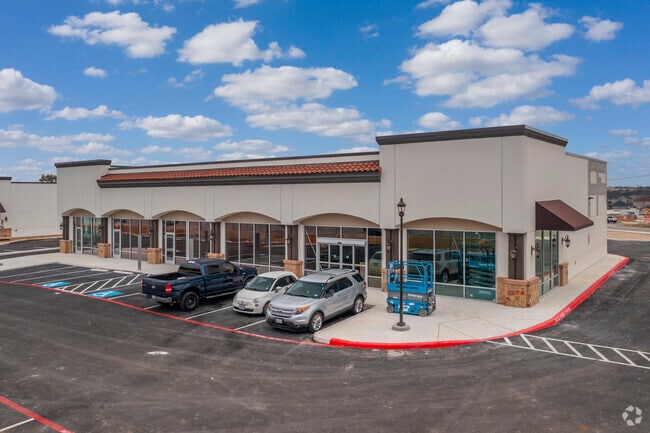
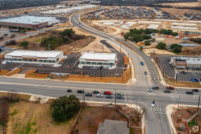
Property Record
11334 Potranco Rd, San Antonio, TX 78253
NEARBY LISTINGS FOR SALE OR LEASE
Property Detail
11334 Potranco Rd
San Antonio-New Braunfels, TX
Cb 4361D(Potranco Market - Ut 6)
04361-449-0020
NCB 19602/CB 4361D ( HIGHLANDS AT DOVE CREEK), BLOCK 4 LOT 2 2022- NEW PER PLAT 20002/713, FILED 05-21-2021
Regionalshoppingcenterormallwithanchorstore
Bexar
X
Texas
48029C0365F
2
2024
1 AC
2025
Far West
172002
San Antonio
7,660 SF
DEMOGRAPHICS near 11334 Potranco Rd
1 Mile
3 Mile
5 Mile
2024 Total Population
13,218
106,051
250,353
2029 Population
14,106
113,630
268,907
Pop Growth 2024-2029
+ 6.72%
+ 7.15%
+ 7.41%
Average Age
34
34
35
2024 Total Households
4,064
33,869
83,349
HH Growth 2024-2029
+ 6.79%
+ 7.22%
+ 7.57%
Median Household Inc
$102,772
$89,943
$80,298
Avg Household Size
3.20
3.10
2.90
2024 Avg HH Vehicles
2.00
2.00
2.00
Median Home Value
$234,069
$230,169
$228,155
Median Year Built
2002
2005
2005
Nearby Places
Map Layers
Map Styles
 Street
 Aerial
- Restaurants
- Banks
- Shops
- Fitness
- Groceries
PUBLIC TRANSPORTATION
AIRPORT
San Antonio International
DRIVE
WALK
Distance
San Antonio International
25 min
17.2 mi
Freight Ports
Port of Corpus Christi
DRIVE
WALK
Distance
Port of Corpus Christi
165 min
156.6 mi
SALE & LEASE HISTORY
LISTING DATE
SALE/LEASE

Mar 12, 2021
For Lease
Nearby Properties
Address
Land Use
TOTAL SIZE
Lot Size
Zoning
Address
Land Use
TOTAL SIZE
Lot Size
Zoning
315,000 SF
24.20 AC
Address
Land Use
TOTAL SIZE
Lot Size
Zoning
257,232 SF
66.01 AC
Address
Land Use
TOTAL SIZE
Lot Size
Zoning
236,594 SF
25.35 AC
Address
Land Use
TOTAL SIZE
Lot Size
Zoning
304,232 SF
99.80 AC
Address
Land Use
TOTAL SIZE
Lot Size
Zoning
361,708 SF
17.83 AC
Address
Land Use
TOTAL SIZE
Lot Size
Zoning
532,921 SF
21.80 AC
Address
Land Use
TOTAL SIZE
Lot Size
Zoning
50,135 SF
10.96 AC
Address
Land Use
TOTAL SIZE
Lot Size
Zoning
368,012 SF
22.27 AC
Address
Land Use
TOTAL SIZE
Lot Size
Zoning
375,203 SF
15.99 AC
Address
Land Use
TOTAL SIZE
Lot Size
Zoning
360,108 SF
24 AC
Address
Land Use
TOTAL SIZE
Lot Size
Zoning
299,795 SF
16.13 AC
Address
Land Use
TOTAL SIZE
Lot Size
Zoning
302,851 SF
14.98 AC
Address
Land Use
TOTAL SIZE
Lot Size
Zoning
241,445 SF
15.86 AC
Address
Land Use
TOTAL SIZE
Lot Size
Zoning
324,175 SF
39.17 AC
Address
Land Use
TOTAL SIZE
Lot Size
Zoning
117,907 SF
9.50 AC
Address
Land Use
TOTAL SIZE
Lot Size
Zoning
577,717 SF
418.25 AC
Address
Land Use
TOTAL SIZE
Lot Size
Zoning
276,312 SF
12 AC
Address
Land Use
TOTAL SIZE
Lot Size
Zoning
209,657 SF
26.97 AC
Address
Land Use
TOTAL SIZE
Lot Size
Zoning
263,255 SF
14.59 AC
Address
Land Use
TOTAL SIZE
Lot Size
Zoning
263,976 SF
17.42 AC
Address
Land Use
TOTAL SIZE
Lot Size
Zoning
209,459 SF
18.25 AC
Address
Land Use
TOTAL SIZE
Lot Size
Zoning
319,143 SF
30.15 AC
Address
Land Use
TOTAL SIZE
Lot Size
Zoning
266,680 SF
30.19 AC
Address
Land Use
TOTAL SIZE
Lot Size
Zoning
228,847 SF
38.28 AC
Address
Land Use
TOTAL SIZE
Lot Size
Zoning
1,152 SF
133.72 AC
Address
Land Use
TOTAL SIZE
Lot Size
Zoning
165,284 SF
16.41 AC
Address
Land Use
TOTAL SIZE
Lot Size
Zoning
256,800 SF
15.95 AC
Address
Land Use
TOTAL SIZE
Lot Size
Zoning
221,920 SF
12.50 AC
Address
Land Use
TOTAL SIZE
Lot Size
Zoning
275,619 SF
32.92 AC
Address
Land Use
TOTAL SIZE
Lot Size
Zoning
93,480 SF
11.34 AC
The World's #1 Commercial Real Estate Marketplace
Connect with us
© 2025 CoStar Group
The information above has been obtained from sources believed reliable. While we do not doubt its accuracy we have not verified it and make no guarantee, warranty or representation about it. It is your responsibility to independently confirm its accuracy and completeness. Any projections, opinions, assumptions, or estimates used are for example only and do not represent the current or future performance of the property. The value of this transaction to you depends on tax and other factors which should be evaluated by your tax, financial, and legal advisors. You and your advisors should conduct a careful, independent investigation of the property to determine to your satisfaction the suitability of the property for your needs.