Property Record
1135 State Road 20, Interlachen, FL 32148
This Property Is For Sale
NEARBY LISTINGS FOR SALE OR LEASE
-
-
View all Interlachen listings for sale on LoopNet.com
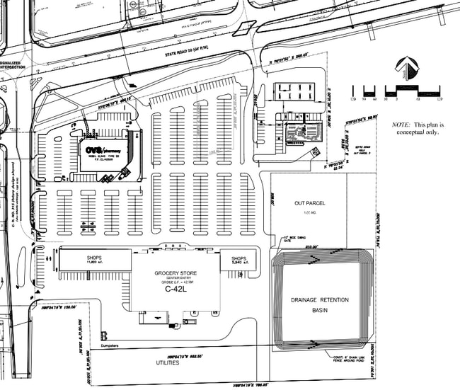
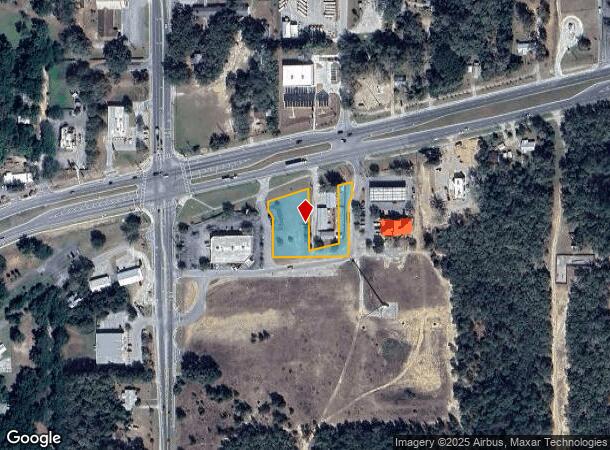
Property Detail
1135 State Road 20
15-10-24-0000-0130-0010
PT OF NE1/4 BK82 P59 OR151, P571 OR185 P608 OR928 P1327, OR959 P1827 (EX BK126 P378, OR1081 P1072 OR1126 P1398, OR1154 P521 OR1380 P1847), (SUBJECT TO FPL ESMT OR1161, P1893)
Commercialacreage
Putnam
X
Florida
12019C0500E
0.88 AC
2025
Florida Central North Area
2025
Other Market Areas
950500
Palatka, FL
DEMOGRAPHICS near 1135 State Road 20
1 Mile
3 Mile
5 Mile
2024 Total Population
984
8,310
11,851
2029 Population
1,029
8,672
12,413
Pop Growth 2024-2029
+ 4.57%
+ 4.36%
+ 4.74%
Average Age
44
44
43
2024 Total Households
404
3,369
4,751
HH Growth 2024-2029
+ 4.46%
+ 4.19%
+ 4.61%
Median Household Inc
$31,154
$32,850
$33,551
Avg Household Size
2.40
2.40
2.50
2024 Avg HH Vehicles
2.00
2.00
2.00
Median Home Value
$80,828
$76,814
$75,673
Median Year Built
1989
1987
1987
Nearby Places
- Restaurants
- Banks
- Shops
- Fitness
- Groceries
PUBLIC TRANSPORTATION
AIRPORT
Gainesville Regional
DRIVE
WALK
Distance
Gainesville Regional
46 min
31.8 mi
Nearby Properties
Address
Land Use
TOTAL SIZE
Lot Size
Zoning
Address
Land Use
TOTAL SIZE
Lot Size
Zoning
4,864 SF
39.09 AC
Address
Land Use
TOTAL SIZE
Lot Size
Zoning
97,000 SF
19.64 AC
Address
Land Use
TOTAL SIZE
Lot Size
Zoning
499.30 AC
Address
Land Use
TOTAL SIZE
Lot Size
Zoning
53,086 SF
11.05 AC
Address
Land Use
TOTAL SIZE
Lot Size
Zoning
23,138 SF
7.80 AC
Address
Land Use
TOTAL SIZE
Lot Size
Zoning
11,918 SF
3.91 AC
Address
Land Use
TOTAL SIZE
Lot Size
Zoning
11,683 SF
1.24 AC
Address
Land Use
TOTAL SIZE
Lot Size
Zoning
3.84 AC
Address
Land Use
TOTAL SIZE
Lot Size
Zoning
3,774 SF
7.02 AC
Address
Land Use
TOTAL SIZE
Lot Size
Zoning
3,504 SF
1.28 AC
Address
Land Use
TOTAL SIZE
Lot Size
Zoning
11,864 SF
3 AC
Address
Land Use
TOTAL SIZE
Lot Size
Zoning
14,306 SF
7.13 AC
Address
Land Use
TOTAL SIZE
Lot Size
Zoning
2,330 SF
1.91 AC
Address
Land Use
TOTAL SIZE
Lot Size
Zoning
9,000 SF
1.64 AC
Address
Land Use
TOTAL SIZE
Lot Size
Zoning
3,478 SF
6.87 AC
Address
Land Use
TOTAL SIZE
Lot Size
Zoning
Address
Land Use
TOTAL SIZE
Lot Size
Zoning
Address
Land Use
TOTAL SIZE
Lot Size
Zoning
756 SF
1.35 AC
Address
Land Use
TOTAL SIZE
Lot Size
Zoning
1,452 SF
2.89 AC
Address
Land Use
TOTAL SIZE
Lot Size
Zoning
8,640 SF
2.72 AC
Address
Land Use
TOTAL SIZE
Lot Size
Zoning
7,200 SF
24.47 AC
Address
Land Use
TOTAL SIZE
Lot Size
Zoning
11,037 SF
2.72 AC
Address
Land Use
TOTAL SIZE
Lot Size
Zoning
6,336 SF
0.62 AC
Address
Land Use
TOTAL SIZE
Lot Size
Zoning
6,708 SF
1.06 AC
Address
Land Use
TOTAL SIZE
Lot Size
Zoning
3,304 SF
3.90 AC
Address
Land Use
TOTAL SIZE
Lot Size
Zoning
7,790 SF
4.14 AC
Address
Land Use
TOTAL SIZE
Lot Size
Zoning
2,100 SF
3.95 AC
Address
Land Use
TOTAL SIZE
Lot Size
Zoning
1,712 SF
0.99 AC
Address
Land Use
TOTAL SIZE
Lot Size
Zoning
307.36 AC
Address
Land Use
TOTAL SIZE
Lot Size
Zoning
992 SF
26.78 AC
The World's #1 Commercial Real Estate Marketplace
Connect with us
© 2025 CoStar Group
The information above has been obtained from sources believed reliable. While we do not doubt its accuracy we have not verified it and make no guarantee, warranty or representation about it. It is your responsibility to independently confirm its accuracy and completeness. Any projections, opinions, assumptions, or estimates used are for example only and do not represent the current or future performance of the property. The value of this transaction to you depends on tax and other factors which should be evaluated by your tax, financial, and legal advisors. You and your advisors should conduct a careful, independent investigation of the property to determine to your satisfaction the suitability of the property for your needs.